Viger (Viger)

- commune in Hautes-Pyrénées, France
- Country:

- Postal Code: 65100
- Coordinates: 43° 3' 44" N, 0° 2' 55" E


- GPS tracks (wikiloc): [Link]
- Area: 3.37 sq km
- Population: 133
- Wikipedia en: wiki(en)
- Wikipedia: wiki(fr)
- Wikidata storage: Wikidata: Q338277
- Wikipedia Commons Category: [Link]
- Freebase ID: [/m/03nv7hw]
- Freebase ID: [/m/03nv7hw]
- GeoNames ID: Alt: [2969153]
- GeoNames ID: Alt: [2969153]
- SIREN number: [216504704]
- SIREN number: [216504704]
- BnF ID: [15270899r]
- BnF ID: [15270899r]
- INSEE municipality code: 65470
- INSEE municipality code: 65470
Shares border with regions:


Agos-Vidalos
- commune in Hautes-Pyrénées, France
- Country:
- Postal Code: 65400
- Coordinates: 43° 2' 13" N, 0° 4' 18" E
- GPS tracks (wikiloc): [Link]
- Area: 6.11 sq km
- Population: 430


Aspin-en-Lavedan
- commune in Hautes-Pyrénées, France
- Country:
- Postal Code: 65100
- Coordinates: 43° 4' 30" N, 0° 2' 49" E
- GPS tracks (wikiloc): [Link]
- Area: 1.77 sq km
- Population: 294


Ger
- commune in Hautes-Pyrénées, France
- Country:
- Postal Code: 65100
- Coordinates: 43° 3' 16" N, 0° 2' 23" E
- GPS tracks (wikiloc): [Link]
- Area: 1.94 sq km
- Population: 179


Ossen
- commune in Hautes-Pyrénées, France
- Country:
- Postal Code: 65100
- Coordinates: 43° 4' 14" N, 0° 4' 0" E
- GPS tracks (wikiloc): [Link]
- Area: 6.91 sq km
- Population: 217

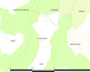
Lugagnan
- commune in Hautes-Pyrénées, France
- Country:
- Postal Code: 65100
- Coordinates: 43° 3' 43" N, 0° 2' 17" E
- GPS tracks (wikiloc): [Link]
- Area: 0.75 sq km
- Population: 144