Vigoux (Vigoux)

- commune in Indre, France
- Country:

- Postal Code: 36170
- Coordinates: 46° 30' 37" N, 1° 29' 15" E


- GPS tracks (wikiloc): [Link]
- Area: 37.51 sq km
- Population: 461
- Web site: http://www.mairie-vigoux36.fr
- Wikipedia en: wiki(en)
- Wikipedia: wiki(fr)
- Wikidata storage: Wikidata: Q1136291
- Wikipedia Commons Category: [Link]
- Freebase ID: [/m/03nvbzs]
- GeoNames ID: Alt: [2969077]
- SIREN number: [213602394]
- BnF ID: [15257543k]
- INSEE municipality code: 36239
Shares border with regions:

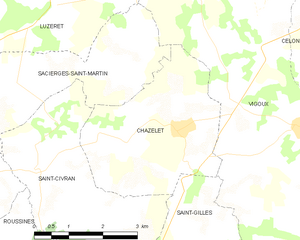
Chazelet
- commune in Indre, France
- Country:
- Postal Code: 36170
- Coordinates: 46° 30' 30" N, 1° 26' 31" E
- GPS tracks (wikiloc): [Link]
- Area: 11.73 sq km
- Population: 117

Celon
- commune in Indre, France
- Country:
- Postal Code: 36200
- Coordinates: 46° 31' 7" N, 1° 29' 59" E
- GPS tracks (wikiloc): [Link]
- Area: 17.04 sq km
- Population: 408

Bazaiges
- commune in Indre, France
- Country:
- Postal Code: 36270
- Coordinates: 46° 29' 56" N, 1° 32' 0" E
- GPS tracks (wikiloc): [Link]
- Area: 18.37 sq km
- Population: 215


Saint-Gilles
- commune in Indre, France
- Country:
- Postal Code: 36170
- Coordinates: 46° 29' 42" N, 1° 26' 41" E
- GPS tracks (wikiloc): [Link]
- Area: 7.68 sq km
- Population: 107


Sacierges-Saint-Martin
- commune in Indre, France
- Country:
- Postal Code: 36170
- Coordinates: 46° 29' 40" N, 1° 21' 54" E
- GPS tracks (wikiloc): [Link]
- Area: 31.17 sq km
- Population: 316
- Web site: [Link]


Parnac
- commune in Indre, France
- Country:
- Postal Code: 36170
- Coordinates: 46° 27' 12" N, 1° 26' 32" E
- GPS tracks (wikiloc): [Link]
- Area: 46.75 sq km
- Population: 508
- Web site: [Link]
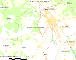
Argenton-sur-Creuse
- commune in Indre, France
- Country:
- Postal Code: 36200
- Coordinates: 46° 35' 20" N, 1° 31' 9" E
- GPS tracks (wikiloc): [Link]
- Area: 29.34 sq km
- Population: 4954
- Web site: [Link]


Thenay
- commune in Indre, France
- Country:
- Postal Code: 36800
- Coordinates: 46° 37' 48" N, 1° 25' 44" E
- GPS tracks (wikiloc): [Link]
- Area: 34.21 sq km
- Population: 874


Luzeret
- commune in Indre, France
- Country:
- Postal Code: 36800
- Coordinates: 46° 32' 30" N, 1° 23' 32" E
- GPS tracks (wikiloc): [Link]
- Area: 26.78 sq km
- Population: 149