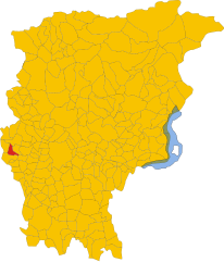
Villa d'Adda (Villa d'Adda)
.svg)
- Italian comune
 Hiking in Villa d'Adda
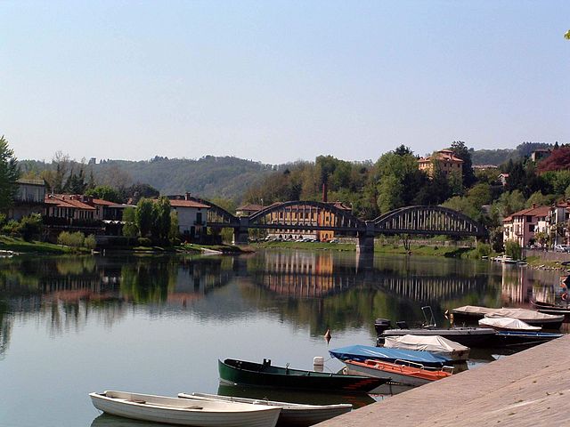
Villa d'Adda is a charming location in Italy, situated on the banks of the Adda River in the Lombardy region. This area is well-suited for hiking enthusiasts, offering scenic trails, beautiful landscapes, and opportunities to experience local culture.
Hiking Trails
-
Adda River Path (Sentiero del Fiume Adda): One of the key highlights of the area is the hiking path that runs alongside the Adda River. This route offers picturesque views of the river, lush greenery, and various points of interest such as historical sites and local flora and fauna.
-
Natural Reserves: Explore nearby natural reserves, such as the Parco Adda Nord. This park provides well-marked trails that lead you through diverse ecosystems, featuring forests, wetlands, and open fields. Birdwatching is also popular here.
-
Historical Routes: There are several trails that connect to historical landmarks, including ancient churches and ruins of old mills that reflect the local history and architecture.
Trail Difficulty
The trails in and around Villa d'Adda vary in difficulty, making them suitable for both beginners and experienced hikers. Many paths are relatively flat and easy to navigate, while some more rugged routes may require a moderate level of fitness.
Best Times to Hike
The best time to hike in Villa d'Adda is during spring and early autumn when the weather is mild and the landscapes are particularly vibrant. Summer can be hot, while winter may bring colder weather and snow in higher altitudes.
Tips for Hiking
- Wear Appropriate Footwear: Sturdy hiking boots or shoes are essential for comfortable walking on varied terrains.
- Stay Hydrated: Carry enough water, especially during warmer months.
- Check Weather Conditions: Always check the local weather forecast before heading out.
- Bring a Map or GPS: While trails are marked, having a detailed map or a navigation app can be helpful for exploring new routes.
- Respect Nature: Follow Leave No Trace principles to keep the trails and surroundings clean.
Local Culture
When you're done with hiking, take some time to explore the quaint village, enjoy local cuisine, and interact with the welcoming community. There are often small cafes and restaurants where you can relax and taste regional dishes.
Hiking in Villa d'Adda is not just about the trails; it’s also about the experience of nature intertwined with local culture and history. Enjoy your adventure!
- Country:

- Postal Code: 24030
- Local Dialing Code: 035
- Licence Plate Code: BG
- Coordinates: 45° 43' 0" N, 9° 28' 0" E


- GPS tracks (wikiloc): [Link]
- AboveSeaLevel: 286 м m
- Area: 5.98 sq km
- Population: 4681
- Web site: http://www.comune.villadadda.bg.it
- Wikipedia en: wiki(en)
- Wikipedia: wiki(it)
- Wikidata storage: Wikidata: Q101759
- Wikipedia Commons Gallery: [Link]
- Wikipedia Commons Category: [Link]
- Freebase ID: [/m/0gjfsy]
- GeoNames ID: Alt: [6543170]
- VIAF ID: Alt: [236600133]
- OSM relation ID: [45802]
- archINFORM location ID: [6911]
- UN/LOCODE: [ITVDD]
- ISTAT ID: 016238
- Italian cadastre code: L929
Shares border with regions:


Calusco d'Adda
- Italian comune
Hiking in Calusco d'Adda
Calusco d'Adda, located in the Lombardy region of Italy, offers a charming setting for hiking enthusiasts. The area is characterized by picturesque landscapes, rolling hills, and the meandering Adda River. Here are some key points to consider when hiking in and around Calusco d'Adda:...
- Country:
- Postal Code: 24033
- Local Dialing Code: 035
- Licence Plate Code: BG
- Coordinates: 45° 41' 0" N, 9° 29' 0" E
- GPS tracks (wikiloc): [Link]
- AboveSeaLevel: 273 м m
- Area: 8.33 sq km
- Population: 8378
- Web site: [Link]

Carvico
- Italian comune
Hiking in Carvico
Carvico, located in the Lombardy region of Italy, is a charming destination for hikers and nature enthusiasts. Situated near the stunning Orobie Alps and not far from the picturesque Lake Como, Carvico offers a variety of trails that cater to different skill levels, from leisurely walks to more challenging hikes....
- Country:
- Postal Code: 24030
- Local Dialing Code: 035
- Licence Plate Code: BG
- Coordinates: 45° 42' 0" N, 9° 29' 0" E
- GPS tracks (wikiloc): [Link]
- AboveSeaLevel: 287 м m
- Area: 4.59 sq km
- Population: 4659
- Web site: [Link]


Pontida
- Italian comune
Hiking in Pontida
Pontida is a charming town located in the province of Bergamo, in the Lombardy region of northern Italy. It is situated near the foothills of the Italian Alps, which makes it an excellent base for hiking and outdoor activities. Here's what you should know about hiking in and around Pontida:...
- Country:
- Postal Code: 24030
- Local Dialing Code: 035
- Licence Plate Code: BG
- Coordinates: 45° 44' 2" N, 9° 30' 23" E
- GPS tracks (wikiloc): [Link]
- AboveSeaLevel: 313 м m
- Area: 10.38 sq km
- Population: 3358
- Web site: [Link]


Robbiate
- Italian comune
Hiking in Robbiate
Robbiate, located in the Lombardy region of Italy, offers various outdoor activities and scenic landscapes for hiking enthusiasts. The area is characterized by its picturesque views, rolling hills, and access to nearby natural parks and trails. Here are some key aspects of hiking in Robbiate:...
- Country:
- Postal Code: 23899
- Local Dialing Code: 039
- Licence Plate Code: LC
- Coordinates: 45° 41' 0" N, 9° 26' 0" E
- GPS tracks (wikiloc): [Link]
- AboveSeaLevel: 265 м m
- Area: 4.7 sq km
- Population: 6337
- Web site: [Link]


Calco
- Italian comune
Hiking in Calco
Calco is a picturesque town located in the Lombardy region of Italy, known for its rich history and beautiful landscapes. While it may not be as popular as some of the well-known hiking destinations in the country, it offers some charming trails for hikers looking to explore the scenic surroundings....
- Country:
- Postal Code: 23885
- Local Dialing Code: 039
- Licence Plate Code: LC
- Coordinates: 45° 43' 0" N, 9° 25' 0" E
- GPS tracks (wikiloc): [Link]
- AboveSeaLevel: 320 м m
- Area: 4.59 sq km
- Population: 5341
- Web site: [Link]

Brivio
- Italian comune
Hiking in Brivio
Brivio, a charming town located in the province of Lecco, Lombardy, Italy, is known for its picturesque landscapes and rich history, making it an appealing destination for hiking enthusiasts. The area surrounding Brivio offers a variety of trails suitable for different experience levels, providing opportunities to explore the beautiful countryside, rivers, and hills....
- Country:
- Postal Code: 23883
- Local Dialing Code: 039
- Licence Plate Code: LC
- Coordinates: 45° 45' 0" N, 9° 27' 0" E
- GPS tracks (wikiloc): [Link]
- AboveSeaLevel: 208 м m
- Area: 7.95 sq km
- Population: 4620
- Web site: [Link]


Imbersago
- Italian comune
Hiking in Imbersago
Imbersago is a charming village located in the Lombardy region of Italy, near the Adda River. It offers a great mix of natural scenery, cultural sites, and opportunities for outdoor activities, making it an attractive destination for hikers and nature lovers....
- Country:
- Postal Code: 23898
- Local Dialing Code: 039
- Licence Plate Code: LC
- Coordinates: 45° 42' 24" N, 9° 26' 43" E
- GPS tracks (wikiloc): [Link]
- AboveSeaLevel: 249 м m
- Area: 3.14 sq km
- Population: 2447
- Web site: [Link]