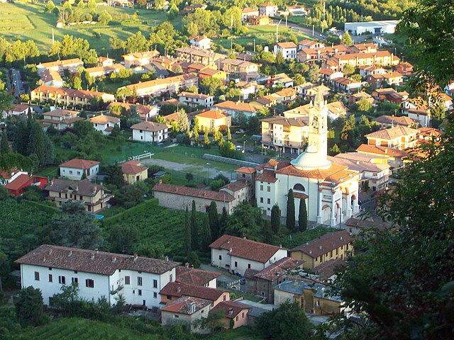
Villa di Serio (Villa di Serio)
.svg)
- Italian comune
 Hiking in Villa di Serio
Villa di Serio is a charming area located in the province of Bergamo in northern Italy, surrounded by beautiful landscapes and nature, making it a great destination for hiking enthusiasts. Here are some details about hiking opportunities in and around Villa di Serio:
Terrain and Trails
- Scenic Landscapes: The area features a mix of hills, forests, and rivers, providing a variety of stunning vistas and natural settings.
- Trail Options: There are numerous trails suitable for different levels of hikers, from easy walks to more challenging hikes. Popular trails can often be found leading to overlooks where you can enjoy panoramic views of the surrounding valleys and mountains.
Popular Hiking Routes
- Monte Misma: This is a well-known hiking destination near Villa di Serio. The trail to the summit offers beautiful views and is accessible for various skill levels.
- The Serio River: Exploring the trails along the Serio River can provide a more relaxed hiking experience, with the opportunity to enjoy the sound of flowing water and the beauty of the riverbanks.
Accessibility
- Starting Points: Many trails can be accessed directly from Villa di Serio, making it convenient for those staying in the area. Look for signs indicating hiking routes and local maps for guidance.
- Local Guidance: It may be beneficial to check in with local tourist information centers for updated trail maps, guided tours, and tips about the best hiking times and conditions.
Additional Tips
- Weather: Always check the weather before heading out, as conditions can change quickly in mountainous areas.
- Equipment: Ensure you have appropriate hiking gear, including sturdy footwear, sufficient water, snacks, and sun protection.
- Sustainability: Respect the local environment by sticking to marked trails and carrying out any litter.
Attractions
- Cultural Sites: Along your hiking routes, you may encounter cultural sites or small villages that reflect the local history and traditions.
- Wildlife: Keep an eye out for local wildlife, and enjoy the diverse flora and fauna unique to this region.
Whether you're looking for an intense hike or a leisurely stroll, Villa di Serio and its surroundings offer a wonderful experience for nature lovers. Don't forget to capture the breathtaking views along the way!
- Country:

- Postal Code: 24020
- Local Dialing Code: 035
- Licence Plate Code: BG
- Coordinates: 45° 43' 18" N, 9° 44' 6" E


- GPS tracks (wikiloc): [Link]
- AboveSeaLevel: 275 м m
- Area: 4.6 sq km
- Population: 6777
- Web site: http://www.comune.villadiserio.bg.it/
- Wikipedia en: wiki(en)
- Wikipedia: wiki(it)
- Wikidata storage: Wikidata: Q101770
- Wikipedia Commons Gallery: [Link]
- Wikipedia Commons Category: [Link]
- Freebase ID: [/m/0gjftp]
- GeoNames ID: Alt: [6536164]
- VIAF ID: Alt: [150371002]
- OSM relation ID: [45878]
- WOEID: [12681967]
- UN/LOCODE: [ITVLD]
- ISTAT ID: 016240
- Italian cadastre code: L936
Shares border with regions:


Nembro
- Italian comune
Hiking in Nembro
Nembro is a charming town located in the province of Bergamo, in the Lombardy region of northern Italy. It is surrounded by beautiful natural landscapes, making it a great destination for hiking enthusiasts. Here are some details about hiking in and around Nembro:...
- Country:
- Postal Code: 24027
- Local Dialing Code: 035
- Licence Plate Code: BG
- Coordinates: 45° 44' 38" N, 9° 45' 34" E
- GPS tracks (wikiloc): [Link]
- AboveSeaLevel: 309 м m
- Area: 15.24 sq km
- Population: 11530
- Web site: [Link]


Ranica
- Italian comune
Hiking in Ranica
Ranica is a picturesque area located in Italy, known for its stunning natural landscapes, making it a great destination for hiking enthusiasts. Here are some key points to consider if you’re planning to hike in Ranica:...
- Country:
- Postal Code: 24020
- Local Dialing Code: 035
- Licence Plate Code: BG
- Coordinates: 45° 44' 0" N, 9° 43' 0" E
- GPS tracks (wikiloc): [Link]
- AboveSeaLevel: 293 м m
- Area: 4.06 sq km
- Population: 5945
- Web site: [Link]

Scanzorosciate
- Italian comune
Hiking in Scanzorosciate
Scanzorosciate is a charming town located in the Lombardy region of northern Italy, near the city of Bergamo. The area offers a variety of hiking opportunities that allow you to explore its stunning landscapes, nature, and cultural heritage....
- Country:
- Postal Code: 24020
- Local Dialing Code: 035
- Licence Plate Code: BG
- Coordinates: 45° 42' 41" N, 9° 44' 9" E
- GPS tracks (wikiloc): [Link]
- AboveSeaLevel: 297 м m
- Area: 10.69 sq km
- Population: 10076
- Web site: [Link]

Alzano Lombardo
- Italian comune
Hiking in Alzano Lombardo
Alzano Lombardo is a charming town located in the Lombardy region of Italy, nestled near the foothills of the Bergamasque Alps. The area offers various hiking opportunities that cater to different skill levels and preferences. Here are some highlights of hiking in and around Alzano Lombardo:...
- Country:
- Postal Code: 24022
- Local Dialing Code: 035
- Licence Plate Code: BG
- Coordinates: 45° 43' 54" N, 9° 43' 42" E
- GPS tracks (wikiloc): [Link]
- AboveSeaLevel: 304 м m
- Area: 13.68 sq km
- Population: 13637
- Web site: [Link]