Villacerf (Villacerf)

- commune in Aube, France
- Country:

- Postal Code: 10600
- Coordinates: 48° 23' 56" N, 3° 59' 28" E


- GPS tracks (wikiloc): [Link]
- Area: 9.64 sq km
- Population: 580
- Wikipedia en: wiki(en)
- Wikipedia: wiki(fr)
- Wikidata storage: Wikidata: Q829958
- Wikipedia Commons Category: [Link]
- Freebase ID: [/m/03m8whc]
- GeoNames ID: Alt: [6426608]
- SIREN number: [211003959]
- BnF ID: [152465016]
- INSEE municipality code: 10409
Shares border with regions:

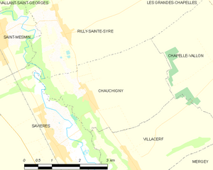
Chauchigny
- commune in Aube, France
- Country:
- Postal Code: 10170
- Coordinates: 48° 25' 24" N, 3° 58' 4" E
- GPS tracks (wikiloc): [Link]
- Area: 9.72 sq km
- Population: 264


Chapelle-Vallon
- commune in Aube, France
- Country:
- Postal Code: 10700
- Coordinates: 48° 26' 8" N, 4° 2' 24" E
- GPS tracks (wikiloc): [Link]
- Area: 19.24 sq km
- Population: 246


Payns
- commune in Aube, France
- Country:
- Postal Code: 10600
- Coordinates: 48° 22' 54" N, 3° 58' 38" E
- GPS tracks (wikiloc): [Link]
- Area: 16.97 sq km
- Population: 1346

Savières
- commune in Aube, France
- Country:
- Postal Code: 10600
- Coordinates: 48° 24' 26" N, 3° 57' 6" E
- GPS tracks (wikiloc): [Link]
- Area: 18.54 sq km
- Population: 1018
- Web site: [Link]


Mergey
- commune in Aube, France
- Country:
- Postal Code: 10600
- Coordinates: 48° 23' 8" N, 4° 0' 16" E
- GPS tracks (wikiloc): [Link]
- Area: 15.01 sq km
- Population: 706