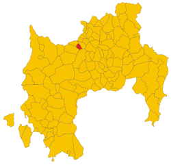
Villanovaforru (Villanovaforru)
- Italian comune
Villanovaforru is located in the province of Medio Campidano in Sardinia, Italy, and is surrounded by breathtaking natural landscapes, making it a unique destination for hiking enthusiasts. The area is characterized by rolling hills, ancient rock formations, and rich Mediterranean vegetation, offering a variety of trails for different skill levels.
Hiking Highlights in Villanovaforru
-
Ancient History: The area is known for its archaeological sites, including nuraghi (ancient stone structures), which can often be incorporated into hiking excursions. Exploring these historic sites along your hike adds a cultural layer to the experience.
-
Scenic Trails: There are numerous trails around Villanovaforru that range from easy walks suitable for families to challenging hikes for more seasoned adventurers. The trails offer stunning views of the surrounding countryside, particularly during sunrise and sunset.
-
Wildlife Watching: The natural habitats around Villanovaforru provide opportunities for wildlife spotting, including various bird species and native plants. Bring binoculars to enhance your experience and possibly catch a glimpse of local fauna.
-
Nearby Natural Parks: The region is close to several natural parks, like the Parco Naturale Regionale del Gennargentu, which offers additional trails and diverse ecosystems to explore.
-
Local Culture: Engaging with the local communities can enrich your hiking experience. Consider stopping in Villanovaforru to learn about traditional Sardinian culture, cuisine, and crafts.
Hiking Tips
- Weather Preparedness: The weather can vary, so check local forecasts before heading out. Layering clothing is advisable.
- Water and Snacks: Always bring enough water and some snacks to keep your energy levels up during the hike.
- Trail Maps: Familiarize yourself with the trails before setting out. Local guides or maps can be useful.
- Footwear: Proper hiking boots are essential to handle varied terrain comfortably.
Whether you're interested in a leisurely stroll or a more strenuous hike, Villanovaforru can offer a captivating experience for outdoor lovers, combining stunning nature, rich history, and vibrant local culture.
- Country:

- Postal Code: 09020
- Local Dialing Code: 070
- Licence Plate Code: SU
- Coordinates: 39° 37' 56" N, 8° 52' 9" E


- GPS tracks (wikiloc): [Link]
- AboveSeaLevel: 324 м m
- Area: 10.93 sq km
- Population: 705
- Web site: http://www.comune.villanovaforru.ca.it/
- Wikipedia en: wiki(en)
- Wikipedia: wiki(it)
- Wikidata storage: Wikidata: Q288478
- Wikipedia Commons Category: [Link]
- Freebase ID: [/m/0gqyp1]
- Freebase ID: [/m/0gqyp1]
- GeoNames ID: Alt: [6539316]
- GeoNames ID: Alt: [6539316]
- VIAF ID: Alt: [158092446]
- VIAF ID: Alt: [158092446]
- OSM relation ID: [40005]
- OSM relation ID: [40005]
- UN/LOCODE: [ITVUU]
- UN/LOCODE: [ITVUU]
- ISTAT ID: 111100
- ISTAT ID: 111100
- Italian cadastre code: L986
- Italian cadastre code: L986
Shares border with regions:


Sanluri
- Italian comune
Sanluri is a small town located in the province of South Sardinia, Italy. While not widely known as a prime hiking destination compared to other parts of Sardinia, it offers opportunities to explore the surrounding natural landscapes and the rich history of the region. Here are some highlights for hiking in and around Sanluri:...
- Country:

- Postal Code: 09025
- Local Dialing Code: 070
- Licence Plate Code: SU
- Coordinates: 39° 33' 40" N, 8° 54' 0" E


- GPS tracks (wikiloc): [Link]
- AboveSeaLevel: 633 м m
- Area: 84.23 sq km
- Population: 8464
- Web site: [Link]


Collinas
- Italian comune
It looks like you may be referring to the Collinas region, which could indicate several places, as "Collinas" might refer to a general term for "hills" in Spanish or Italian, or it may refer to a specific area, such as the Collinas area in Sardinia, Italy. However, since you didn’t specify a location, I'll share general tips and information about hiking in hilly or mountainous regions....
- Country:

- Postal Code: 09020
- Local Dialing Code: 070
- Licence Plate Code: SU
- Coordinates: 39° 38' 26" N, 8° 50' 24" E


- GPS tracks (wikiloc): [Link]
- AboveSeaLevel: 249 м m
- Area: 20.83 sq km
- Population: 829
- Web site: [Link]


Lunamatrona
- Italian comune
Lunamatrona is a small town located in the province of Medio Campidano in Sardinia, Italy. While it might not be as famous as other hiking destinations, it offers unique opportunities for outdoor enthusiasts to explore the beautiful Sardinian landscape....
- Country:

- Postal Code: 09022
- Local Dialing Code: 070
- Licence Plate Code: SU
- Coordinates: 39° 38' 49" N, 8° 54' 1" E


- GPS tracks (wikiloc): [Link]
- AboveSeaLevel: 180 м m
- Area: 20.59 sq km
- Population: 1705
- Web site: [Link]


Sardara
- Italian comune
Sardara is a charming town located in the province of South Sardinia, Italy. Nestled in a region rich with natural beauty, ancient history, and a diversity of landscapes, hiking in and around Sardara can be a wonderful experience for outdoor enthusiasts. Here are some highlights and tips for hiking in the area:...
- Country:

- Postal Code: 09030
- Local Dialing Code: 070
- Licence Plate Code: SU
- Coordinates: 39° 36' 50" N, 8° 49' 17" E


- GPS tracks (wikiloc): [Link]
- AboveSeaLevel: 163 м m
- Area: 56.23 sq km
- Population: 4033
- Web site: [Link]

