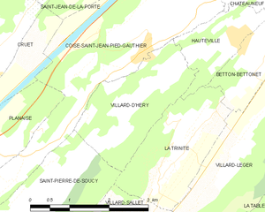
Villard-d'Héry (Villard-d'Héry)
- commune in Savoie, France
Villard-d'Héry is a charming village located in the Savoie region of the French Alps. It's an excellent starting point for various hiking adventures, with picturesque landscapes, alpine meadows, and mountainous terrain. Here are some highlights and tips for hiking in the area:
Trails and Routes
-
Les Aiguilles d'Arves: This is a challenging hike offering breathtaking views of the surrounding peaks. The trail tends to be steep and requires a good level of fitness.
-
Lac de la Sagne: An easier hike ideal for families, this trail takes you to a lovely alpine lake surrounded by lush greenery, perfect for a picnic spot.
-
Col de la Croix de Fer: A popular route with stunning panoramic views, this trail can be accessed from Villard-d'Héry and is great for experienced hikers looking for a half-day or full-day trek.
Difficulty Levels
- Beginner: Look for well-marked paths such as those leading to local lakes.
- Intermediate: Trails that lead to higher altitudes or involve some ascent are suitable.
- Advanced: Consider routes that traverse high mountain passes or require scrambling.
Best Seasons
- Summer (June to September): Ideal for hiking, with trails open and the weather generally pleasant.
- Autumn: The changing colors can make hikes particularly beautiful, though be prepared for cooler temperatures.
Safety Tips
- Check Weather Conditions: Alpine weather can change rapidly. Always check forecasts before heading out.
- Stay On Marked Trails: To preserve the environment and ensure safety, stick to marked paths.
- Pack Essentials: Bring plenty of water, snacks, a map or GPS, sun protection, and appropriate clothing.
Local Attractions
- Wildlife Watching: Keep an eye out for local fauna like ibex or chamois during your hikes.
- Cultural Sites: Don't miss the chance to explore local architecture and community events in Villard-d'Héry.
Conclusion
Villard-d'Héry offers a range of hiking options that can cater to all skill levels. While enjoying the hikes, take in the stunning alpine scenery and the tranquil atmosphere of the French Alps. Always prioritize safety and respect for nature, and you'll have a memorable hiking experience!
- Country:

- Postal Code: 73800
- Coordinates: 45° 30' 52" N, 6° 8' 16" E


- GPS tracks (wikiloc): [Link]
- Area: 4.9 sq km
- Population: 264
- Wikipedia en: wiki(en)
- Wikipedia: wiki(fr)
- Wikidata storage: Wikidata: Q1217101
- Wikipedia Commons Category: [Link]
- Freebase ID: [/m/03npfzm]
- GeoNames ID: Alt: [6442924]
- SIREN number: [217303148]
- BnF ID: [15274244s]
- INSEE municipality code: 73314
Shares border with regions:
La Trinité, Savoie
- commune in Savoie, France
La Trinité, located in the Savoie region of the French Alps, offers a stunning backdrop for hiking enthusiasts. While it may be less well-known than some of the more famous alpine areas, the region is characterized by beautiful landscapes, intricate trails, and the opportunity to experience the local flora and fauna....
- Country:

- Postal Code: 73110
- Coordinates: 45° 29' 55" N, 6° 8' 52" E


- GPS tracks (wikiloc): [Link]
- Area: 4.88 sq km
- Population: 342


Hauteville, Savoie
- commune in Savoie, France
Hauteville, located in the Savoie region of the French Alps, offers stunning landscapes and a variety of hiking opportunities suitable for all skill levels. The area is characterized by beautiful mountain scenery, alpine meadows, and picturesque views....
- Country:

- Postal Code: 73390
- Coordinates: 45° 31' 47" N, 6° 10' 21" E


- GPS tracks (wikiloc): [Link]
- Area: 2.45 sq km
- Population: 347


Coise-Saint-Jean-Pied-Gauthier
- commune in Savoie, France
 Hiking in Coise-Saint-Jean-Pied-Gauthier
Coise-Saint-Jean-Pied-Gauthier, located in the Savoie region of the French Alps, offers stunning hiking opportunities amidst beautiful mountainous landscapes. While specific trails may vary in difficulty and length, here are some general points to consider when hiking in this area:...
- Country:

- Postal Code: 73800
- Coordinates: 45° 31' 32" N, 6° 8' 33" E


- GPS tracks (wikiloc): [Link]
- Area: 10.38 sq km
- Population: 1219


Saint-Pierre-de-Soucy
- commune in Savoie, France
 Hiking in Saint-Pierre-de-Soucy
Saint-Pierre-de-Soucy is a charming municipality in Quebec, Canada, known for its beautiful natural landscapes and outdoor recreational opportunities. Here are some highlights related to hiking in this area:...
- Country:

- Postal Code: 73800
- Coordinates: 45° 29' 39" N, 6° 6' 22" E


- GPS tracks (wikiloc): [Link]
- Area: 9.09 sq km
- Population: 434
