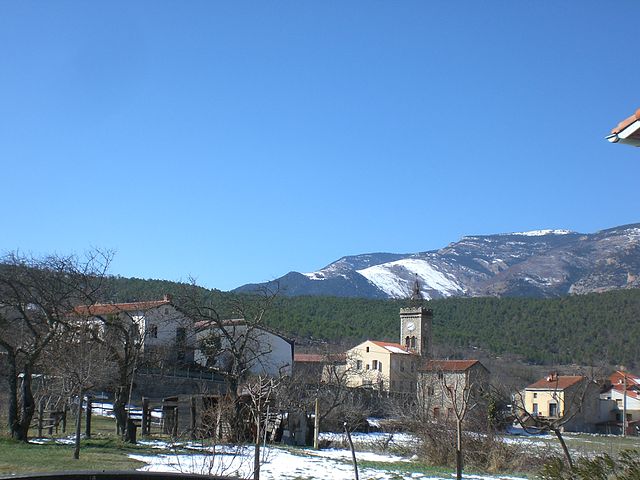
Villefranche-de-Conflent (Villefranche-de-Conflent)

- commune in Pyrénées-Orientales, France
- Country:

- Postal Code: 66500
- Coordinates: 42° 35' 14" N, 2° 22' 4" E


- GPS tracks (wikiloc): [Link]
- Area: 4.46 sq km
- Population: 212
- Web site: http://www.villefranchedeconflent.fr
- Wikipedia en: wiki(en)
- Wikipedia: wiki(fr)
- Wikidata storage: Wikidata: Q501114
- Wikipedia Commons Category: [Link]
- Freebase ID: [/m/098v9n]
- Freebase ID: [/m/098v9n]
- GeoNames ID: Alt: [2968759]
- GeoNames ID: Alt: [2968759]
- SIREN number: [216602235]
- SIREN number: [216602235]
- BnF ID: [15271132s]
- BnF ID: [15271132s]
- VIAF ID: Alt: [143824523]
- VIAF ID: Alt: [143824523]
- OSM relation ID: [392223]
- OSM relation ID: [392223]
- GND ID: Alt: [4737606-5]
- GND ID: Alt: [4737606-5]
- archINFORM location ID: [6836]
- archINFORM location ID: [6836]
- Library of Congress authority ID: Alt: [n82152260]
- Library of Congress authority ID: Alt: [n82152260]
- PACTOLS thesaurus ID: [pcrtEON0DunhsX]
- PACTOLS thesaurus ID: [pcrtEON0DunhsX]
- WOEID: [12672470]
- WOEID: [12672470]
- Gran Enciclopèdia Catalana ID: [0070710]
- Gran Enciclopèdia Catalana ID: [0070710]
- Chemins de mémoire ID: [place-forte-de-villefranche-de-conflent]
- Chemins de mémoire ID: [place-forte-de-villefranche-de-conflent]
- INSEE municipality code: 66223
- INSEE municipality code: 66223
Shares border with regions:


Conat
- commune in Pyrénées-Orientales, France
- Country:
- Postal Code: 66500
- Coordinates: 42° 36' 48" N, 2° 21' 24" E
- GPS tracks (wikiloc): [Link]
- Area: 19.12 sq km
- Population: 56


Corneilla-de-Conflent
- commune in Pyrénées-Orientales, France
- Country:
- Postal Code: 66820
- Coordinates: 42° 33' 59" N, 2° 22' 50" E
- GPS tracks (wikiloc): [Link]
- Area: 11.02 sq km
- Population: 469

Fuilla
- commune in Pyrénées-Orientales, France
- Country:
- Postal Code: 66820
- Coordinates: 42° 33' 43" N, 2° 21' 46" E
- GPS tracks (wikiloc): [Link]
- Area: 9.69 sq km
- Population: 450

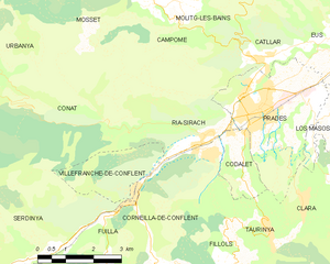
Ria-Sirach
- commune in Pyrénées-Orientales, France
- Country:
- Postal Code: 66500
- Coordinates: 42° 36' 30" N, 2° 23' 59" E
- GPS tracks (wikiloc): [Link]
- AboveSeaLevel: 380 м m
- Area: 12.82 sq km
- Population: 1314
- Web site: [Link]


Serdinya
- commune in Pyrénées-Orientales, France
- Country:
- Postal Code: 66360
- Coordinates: 42° 34' 5" N, 2° 19' 18" E
- GPS tracks (wikiloc): [Link]
- Area: 16.91 sq km
- Population: 244