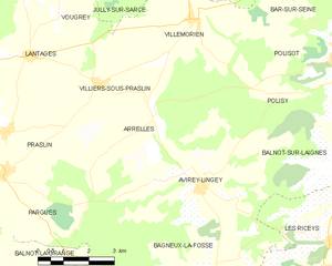
Villemorien (Villemorien)

- commune in Aube, France
- Country:

- Postal Code: 10110
- Coordinates: 48° 5' 8" N, 4° 17' 47" E


- GPS tracks (wikiloc): [Link]
- Area: 13.8 sq km
- Population: 210
- Wikipedia en: wiki(en)
- Wikipedia: wiki(fr)
- Wikidata storage: Wikidata: Q1104456
- Wikipedia Commons Category: [Link]
- Freebase ID: [/m/03m8wlr]
- GeoNames ID: Alt: [6426615]
- SIREN number: [211004064]
- BnF ID: [152465105]
- INSEE municipality code: 10418
Shares border with regions:

Arrelles
- commune in Aube, France
- Country:
- Postal Code: 10340
- Coordinates: 48° 3' 0" N, 4° 16' 33" E
- GPS tracks (wikiloc): [Link]
- Area: 14.36 sq km
- Population: 85


Polisot
- commune in Aube, France
- Country:
- Postal Code: 10110
- Coordinates: 48° 4' 18" N, 4° 22' 19" E
- GPS tracks (wikiloc): [Link]
- Area: 10.52 sq km
- Population: 327
Villiers-sous-Praslin
- commune in Aube, France
- Country:
- Postal Code: 10210
- Coordinates: 48° 3' 44" N, 4° 14' 51" E
- GPS tracks (wikiloc): [Link]
- Area: 8.42 sq km
- Population: 70


Jully-sur-Sarce
- commune in Aube, France
- Country:
- Postal Code: 10260
- Coordinates: 48° 6' 33" N, 4° 18' 18" E
- GPS tracks (wikiloc): [Link]
- Area: 30.44 sq km
- Population: 259

Bar-sur-Seine
- commune in Aube, France
- Country:
- Postal Code: 10110
- Coordinates: 48° 6' 51" N, 4° 22' 33" E
- GPS tracks (wikiloc): [Link]
- AboveSeaLevel: 156 м m
- Area: 27.53 sq km
- Population: 3054
- Web site: [Link]