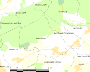
Villers-lès-Luxeuil (Villers-lès-Luxeuil)

- commune in Haute-Saône, France
- Country:

- Postal Code: 70300
- Coordinates: 47° 46' 18" N, 6° 17' 11" E


- GPS tracks (wikiloc): [Link]
- Area: 9.1 sq km
- Population: 310
- Web site: http://villers-les-luxeuil.com
- Wikipedia en: wiki(en)
- Wikipedia: wiki(fr)
- Wikidata storage: Wikidata: Q923378
- Wikipedia Commons Category: [Link]
- Freebase ID: [/m/03nw11q]
- GeoNames ID: Alt: [6442168]
- SIREN number: [217005644]
- INSEE municipality code: 70564
Shares border with regions:


Éhuns
- commune in Haute-Saône, France
- Country:
- Postal Code: 70300
- Coordinates: 47° 46' 22" N, 6° 18' 45" E
- GPS tracks (wikiloc): [Link]
- Area: 5.53 sq km
- Population: 247

Abelcourt
- commune in Haute-Saône, France
- Country:
- Postal Code: 70300
- Coordinates: 47° 47' 7" N, 6° 17' 25" E
- GPS tracks (wikiloc): [Link]
- Area: 7.46 sq km
- Population: 353


Velorcey
- commune in Haute-Saône, France
- Country:
- Postal Code: 70300
- Coordinates: 47° 46' 40" N, 6° 15' 5" E
- GPS tracks (wikiloc): [Link]
- Area: 6.18 sq km
- Population: 221

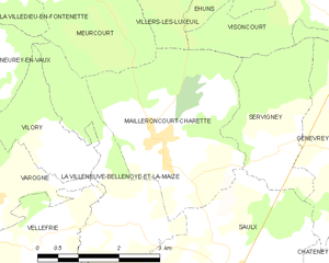
Mailleroncourt-Charette
- commune in Haute-Saône, France
- Country:
- Postal Code: 70240
- Coordinates: 47° 43' 37" N, 6° 15' 35" E
- GPS tracks (wikiloc): [Link]
- Area: 10.6 sq km
- Population: 269


Breuches
- commune in Haute-Saône, France
- Country:
- Postal Code: 70300
- Coordinates: 47° 47' 53" N, 6° 19' 49" E
- GPS tracks (wikiloc): [Link]
- AboveSeaLevel: 279 м m
- Area: 9.12 sq km
- Population: 701

Meurcourt
- commune in Haute-Saône, France
- Country:
- Postal Code: 70300
- Coordinates: 47° 46' 18" N, 6° 13' 59" E
- GPS tracks (wikiloc): [Link]
- Area: 11.89 sq km
- Population: 320

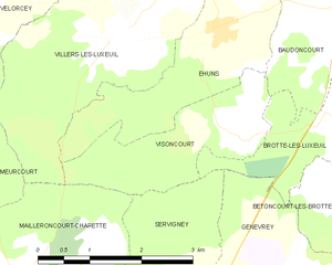
Visoncourt
- commune in Haute-Saône, France
- Country:
- Postal Code: 70300
- Coordinates: 47° 45' 9" N, 6° 19' 1" E
- GPS tracks (wikiloc): [Link]
- Area: 4.52 sq km
- Population: 39

Sainte-Marie-en-Chaux
- commune in Haute-Saône, France
- Country:
- Postal Code: 70300
- Coordinates: 47° 47' 22" N, 6° 18' 45" E
- GPS tracks (wikiloc): [Link]
- Area: 2.43 sq km
- Population: 169