Villers-la-Montagne (Villers-la-Montagne)

- commune in Meurthe-et-Moselle, France
- Country:

- Postal Code: 54920
- Coordinates: 49° 28' 15" N, 5° 49' 17" E


- GPS tracks (wikiloc): [Link]
- Area: 18.12 sq km
- Population: 1482
- Wikipedia en: wiki(en)
- Wikipedia: wiki(fr)
- Wikidata storage: Wikidata: Q589517
- Wikipedia Commons Category: [Link]
- Freebase ID: [/m/03qdn_0]
- Freebase ID: [/m/03qdn_0]
- Freebase ID: [/m/03qdn_0]
- GeoNames ID: Alt: [6436919]
- GeoNames ID: Alt: [6436919]
- GeoNames ID: Alt: [6436919]
- SIREN number: [215405754]
- SIREN number: [215405754]
- SIREN number: [215405754]
- BnF ID: [152646420]
- BnF ID: [152646420]
- BnF ID: [152646420]
- VIAF ID: Alt: [139874981]
- VIAF ID: Alt: [139874981]
- VIAF ID: Alt: [139874981]
- Library of Congress authority ID: Alt: [no99000816]
- Library of Congress authority ID: Alt: [no99000816]
- Library of Congress authority ID: Alt: [no99000816]
- INSEE municipality code: 54575
- INSEE municipality code: 54575
- INSEE municipality code: 54575
Shares border with regions:

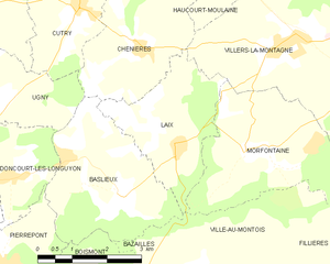
Laix
- commune in Meurthe-et-Moselle, France
- Country:
- Postal Code: 54720
- Coordinates: 49° 26' 48" N, 5° 46' 48" E
- GPS tracks (wikiloc): [Link]
- Area: 7.55 sq km
- Population: 199

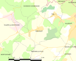
Tiercelet
- commune in Meurthe-et-Moselle, France
- Country:
- Postal Code: 54190
- Coordinates: 49° 27' 43" N, 5° 53' 3" E
- GPS tracks (wikiloc): [Link]
- Area: 7.68 sq km
- Population: 650


Chenières
- commune in Meurthe-et-Moselle, France
- Country:
- Postal Code: 54720
- Coordinates: 49° 28' 16" N, 5° 45' 56" E
- GPS tracks (wikiloc): [Link]
- Area: 8.5 sq km
- Population: 637

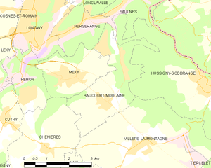
Haucourt-Moulaine
- commune in Meurthe-et-Moselle, France
- Country:
- Postal Code: 54860
- Coordinates: 49° 29' 23" N, 5° 48' 23" E
- GPS tracks (wikiloc): [Link]
- Area: 7.42 sq km
- Population: 3076

Morfontaine
- commune in Meurthe-et-Moselle, France
- Country:
- Postal Code: 54920
- Coordinates: 49° 26' 40" N, 5° 48' 30" E
- GPS tracks (wikiloc): [Link]
- Area: 11.42 sq km
- Population: 1098

Hussigny-Godbrange
- commune in Meurthe-et-Moselle, France
- Country:
- Postal Code: 54590
- Coordinates: 49° 29' 34" N, 5° 52' 27" E
- GPS tracks (wikiloc): [Link]
- Area: 15.37 sq km
- Population: 3514
- Web site: [Link]


Bréhain-la-Ville
- commune in Meurthe-et-Moselle, France
- Country:
- Postal Code: 54190
- Coordinates: 49° 26' 15" N, 5° 52' 53" E
- GPS tracks (wikiloc): [Link]
- Area: 10.08 sq km
- Population: 372