Virieu (Virieu)

- commune in Isère, France
 Hiking in Virieu
Virieu is a charming commune located in the Auvergne-Rhône-Alpes region of France. It's surrounded by picturesque landscapes, making it an excellent destination for hiking enthusiasts. Here are some key aspects of hiking in Virieu:
Scenic Trails
- Varied Terrain: The area offers a mix of terrains, including forests, hills, and lakes, providing diverse hiking experiences for different skill levels.
- Natural Beauty: The trails in and around Virieu often feature stunning views of the surrounding mountains, valleys, and sometimes the nearby Rhône River.
- Wildlife and Flora: Hikers may encounter diverse flora and fauna along the trails, making it a great spot for nature lovers and wildlife photographers.
Popular Hiking Routes
- Local Trails: Many local trails are well-marked and accessible for both beginners and experienced hikers. Look for routes that loop around the area or lead to lookout points.
- Guided Hikes: Consider joining guided hikes if you want to learn more about the local ecology and get the most out of your experience.
Tips for Hiking in Virieu
- Weather Preparedness: Weather can be unpredictable, so it's wise to check the forecast and dress in layers.
- Stay Hydrated: Always carry enough water, as some trails may not have accessible water sources.
- Respect Nature: Follow Leave No Trace principles to preserve the natural beauty of the area.
Nearby Attractions
- Château de Virieu: After a day of hiking, you can explore the nearby historic château, which may provide insights into local history and architecture.
- Lakes and Parks: Visit local lakes or parks for a relaxing afternoon or further hiking opportunities.
Whether you’re looking for a leisurely hike to enjoy the scenery or a more challenging trek, Virieu has a range of options to offer. Make sure to check local guides or visitor centers for the latest information on trails and conditions!
- Country:

- Postal Code: 38730
- Coordinates: 45° 29' 8" N, 5° 28' 32" E


- GPS tracks (wikiloc): [Link]
- Area: 11.38 sq km
- Population: 1110
- Web site: http://www.mairie-virieu.fr
- Wikipedia en: wiki(en)
- Wikipedia: wiki(fr)
- Wikidata storage: Wikidata: Q1011549
- Wikipedia Commons Category: [Link]
- Freebase ID: [/m/03nvjht]
- GeoNames ID: Alt: [6454096]
- SIREN number: [213805609]
- BnF ID: [15258360v]
- PACTOLS thesaurus ID: [pcrtcto5FdbaUZ]
- INSEE municipality code: 38560
Shares border with regions:


Châbons
- commune in Isère, France
Hiking in Châbons
Châbons is a charming town located in the Isère department of the Auvergne-Rhône-Alpes region in southeastern France. It's surrounded by beautiful landscapes and offers various hiking opportunities suitable for different levels of experience. Here are some highlights regarding hiking in and around Châbons:...
- Country:
- Postal Code: 38690
- Coordinates: 45° 26' 38" N, 5° 25' 51" E
- GPS tracks (wikiloc): [Link]
- Area: 18.14 sq km
- Population: 2098
- Web site: [Link]

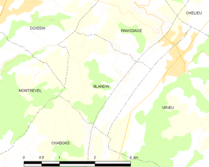
Blandin
- commune in Isère, France
Hiking in Blandin
Blandin, located in Minnesota, is known for its beautiful landscapes and outdoor recreational opportunities, including hiking. The area offers a variety of trails suited for different skill levels and preferences, ranging from leisurely walks to more challenging hikes....
- Country:
- Postal Code: 38730
- Coordinates: 45° 28' 11" N, 5° 26' 53" E
- GPS tracks (wikiloc): [Link]
- Area: 4.26 sq km
- Population: 141


Valencogne
- commune in Isère, France
Hiking in Valencogne
Valencogne is a lesser-known but beautiful destination for hiking, located in the French Alps. Here are some highlights and tips for hiking in this area:...
- Country:
- Postal Code: 38730
- Coordinates: 45° 29' 57" N, 5° 32' 24" E
- GPS tracks (wikiloc): [Link]
- Area: 7.55 sq km
- Population: 662
- Web site: [Link]


Le Pin
- former commune in Isère, France
Hiking in Le Pin
Le Pin, located in the Isère department of the Auvergne-Rhône-Alpes region in France, offers beautiful hiking opportunities with picturesque landscapes and a variety of trails suited for different skill levels. Here are some insights into hiking in the area:...
- Country:
- Postal Code: 38730
- Coordinates: 45° 27' 24" N, 5° 30' 20" E
- GPS tracks (wikiloc): [Link]
- Area: 9.6 sq km
- Population: 1255
- Web site: [Link]


Oyeu
- commune in Isère, France
Hiking in Oyeu
Oyeu is a charming municipality located in the Auvergne-Rhône-Alpes region of France, known for its picturesque landscapes and outdoor activities, including hiking. Although Oyeu might not be as famous as some larger hiking destinations, it offers a range of trails that cater to various skill levels and preferences....
- Country:
- Postal Code: 38690
- Coordinates: 45° 25' 19" N, 5° 28' 28" E
- GPS tracks (wikiloc): [Link]
- Area: 13.69 sq km
- Population: 956
- Web site: [Link]


Burcin
- commune in Isère, France
Hiking in Burcin
Burcin is a picturesque area in Turkey known for its beautiful landscapes and options for outdoor activities, including hiking. It is situated in the Bolu Province, which is part of the larger region that is famed for its natural beauty, featuring lush forests, rolling hills, and a variety of flora and fauna....
- Country:
- Postal Code: 38690
- Coordinates: 45° 25' 53" N, 5° 26' 15" E
- GPS tracks (wikiloc): [Link]
- Area: 6.69 sq km
- Population: 408
- Web site: [Link]


Panissage
- commune in Isère, France
Hiking in Panissage
I'm sorry, but it seems like there isn't a well-known hiking destination specifically called "Panissage." It's possible that it might be a lesser-known area, a local spot, or perhaps a misspelling of another location....
- Country:
- Postal Code: 38730
- Coordinates: 45° 29' 39" N, 5° 27' 47" E
- GPS tracks (wikiloc): [Link]
- Area: 4.88 sq km
- Population: 448

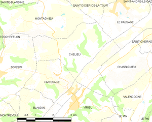
Chélieu
- commune in Isère, France
Hiking in Chélieu
Chélieu, located in the Isère department of the Auvergne-Rhône-Alpes region in France, offers beautiful landscapes and opportunities for hiking enthusiasts. The area is characterized by its stunning mountainous terrain, with the Chartreuse Mountains nearby providing a range of trails suitable for different skill levels....
- Country:
- Postal Code: 38730
- Coordinates: 45° 30' 44" N, 5° 28' 33" E
- GPS tracks (wikiloc): [Link]
- AboveSeaLevel: 607 м m
- Area: 10.13 sq km
- Population: 674
- Web site: [Link]