Voigny (Voigny)

- commune in Aube, France
- Country:

- Postal Code: 10200
- Coordinates: 48° 14' 27" N, 4° 46' 5" E


- GPS tracks (wikiloc): [Link]
- Area: 7.09 sq km
- Population: 164
- Wikipedia en: wiki(en)
- Wikipedia: wiki(fr)
- Wikidata storage: Wikidata: Q974926
- Wikipedia Commons Category: [Link]
- Freebase ID: [/m/03m8wtz]
- GeoNames ID: Alt: [6426634]
- SIREN number: [211004254]
- BnF ID: [15246532g]
- INSEE municipality code: 10440
Shares border with regions:


Arrentières
- commune in Aube, France
- Country:
- Postal Code: 10200
- Coordinates: 48° 15' 48" N, 4° 44' 33" E
- GPS tracks (wikiloc): [Link]
- Area: 13.91 sq km
- Population: 224

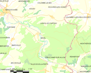
Bayel
- commune in Aube, France
- Country:
- Postal Code: 10310
- Coordinates: 48° 11' 56" N, 4° 46' 31" E
- GPS tracks (wikiloc): [Link]
- Area: 23 sq km
- Population: 772


Bar-sur-Aube
- commune in Aube, France
- Country:
- Postal Code: 10200
- Coordinates: 48° 13' 59" N, 4° 42' 23" E
- GPS tracks (wikiloc): [Link]
- AboveSeaLevel: 166 м m
- Area: 16.27 sq km
- Population: 4978
- Web site: [Link]

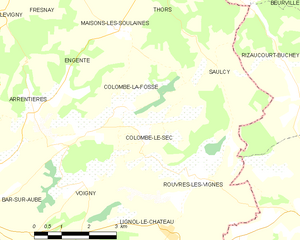
Colombé-le-Sec
- commune in Aube, France
- Country:
- Postal Code: 10200
- Coordinates: 48° 15' 17" N, 4° 47' 48" E
- GPS tracks (wikiloc): [Link]
- Area: 8.78 sq km
- Population: 151

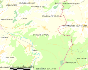
Lignol-le-Château
- commune in Aube, France
- Country:
- Postal Code: 10200
- Coordinates: 48° 13' 25" N, 4° 48' 27" E
- GPS tracks (wikiloc): [Link]
- Area: 21.85 sq km
- Population: 198
Colombé-la-Fosse
- commune in Aube, France
- Country:
- Postal Code: 10200
- Coordinates: 48° 15' 50" N, 4° 47' 15" E
- GPS tracks (wikiloc): [Link]
- Area: 9.31 sq km
- Population: 196