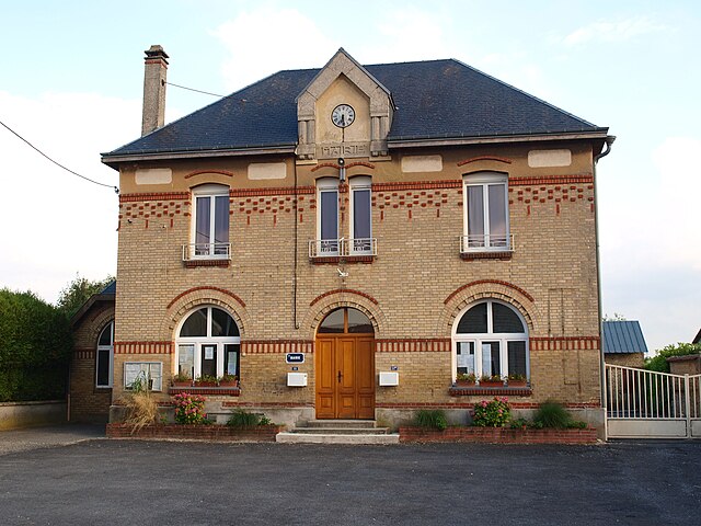
Warmeriville (Warmeriville)

- commune in Marne, France
- Country:

- Postal Code: 51110
- Coordinates: 49° 21' 2" N, 4° 13' 19" E


- GPS tracks (wikiloc): [Link]
- Area: 23.25 sq km
- Population: 2354
- Web site: http://www.warmeriville.fr
- Wikipedia en: wiki(en)
- Wikipedia: wiki(fr)
- Wikidata storage: Wikidata: Q1224836
- Wikipedia Commons Category: [Link]
- Freebase ID: [/m/03qdc9h]
- GeoNames ID: Alt: [6436116]
- SIREN number: [215106121]
- BnF ID: [152632492]
- PACTOLS thesaurus ID: [pcrt8bhneakFHS]
- INSEE municipality code: 51660
Shares border with regions:

Aussonce
- commune in Ardennes, France
- Country:
- Postal Code: 08310
- Coordinates: 49° 21' 1" N, 4° 19' 21" E
- GPS tracks (wikiloc): [Link]
- Area: 19.14 sq km
- Population: 213
Ménil-Lépinois
- commune in Ardennes, France
- Country:
- Postal Code: 08310
- Coordinates: 49° 22' 43" N, 4° 17' 6" E
- GPS tracks (wikiloc): [Link]
- Area: 18.01 sq km
- Population: 135

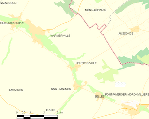
Heutrégiville
- commune in Marne, France
- Country:
- Postal Code: 51110
- Coordinates: 49° 19' 0" N, 4° 16' 0" E
- GPS tracks (wikiloc): [Link]
- AboveSeaLevel: 94 м m
- Area: 11.62 sq km
- Population: 406
- Web site: [Link]


Lavannes
- commune in Marne, France
- Country:
- Postal Code: 51110
- Coordinates: 49° 18' 49" N, 4° 10' 16" E
- GPS tracks (wikiloc): [Link]
- Area: 17.77 sq km
- Population: 623
- Web site: [Link]

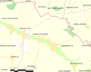
Isles-sur-Suippe
- commune in Marne, France
- Country:
- Postal Code: 51110
- Coordinates: 49° 21' 24" N, 4° 12' 3" E
- GPS tracks (wikiloc): [Link]
- Area: 12.39 sq km
- Population: 866