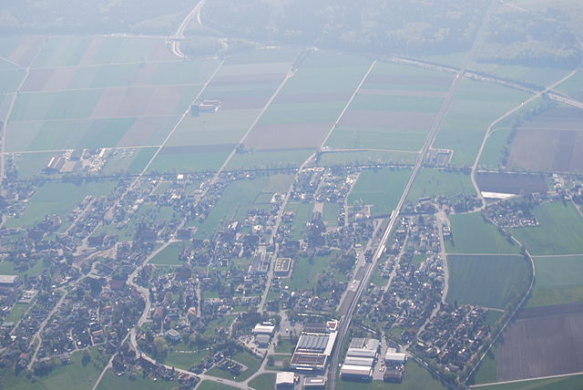
Wasseramt District (Bezirk Wasseramt)
- district of the canton of Solothurn, Switzerland
 Hiking in Wasseramt District
Wasseramt District is located in the canton of Solothurn in Switzerland, known for its picturesque landscapes, rolling hills, and access to various hiking trails. Here are some highlights and tips for hiking in the Wasseramt District:
Hiking Trails
-
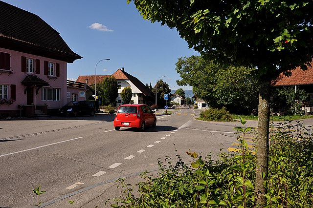
Büren an der Aare: This quaint town is a great starting point for several trails that meander along the Aare River, offering beautiful views and opportunities for birdwatching.
-
Wasseramt Nature Trails: There are numerous marked trails that traverse the scenic countryside. These trails vary in difficulty, catering to both beginners and more experienced hikers.
-
Lush Meadows and Vineyards: Many trails pass through lush meadows and vineyards, where you can enjoy the tranquility and perhaps sample some local wines.
-
Historical Routes: Some trails showcase the region's rich history, including old churches and cultural landmarks.
Best Practices for Hiking
-
Trail Maps: Make sure to carry a detailed map or use a hiking app to track your route, as trail markings can vary.
-
Weather Conditions: Check the weather before heading out, as conditions can change rapidly in the Alps.
-
Equipment: Wear sturdy hiking boots and bring enough water and snacks. Depending on the season, appropriate clothing for warmth or sun protection is advisable.
-
Safety: Always let someone know your hiking plans and estimated return time, especially if you venture on less-traveled paths.
Local Flora and Fauna
The area is home to diverse plant species and wildlife. Keep an eye out for local flora, especially during spring when wildflowers bloom. Birdwatching can be particularly rewarding near bodies of water.
Conclusion
Hiking in Wasseramt District is a rewarding experience with its natural beauty, serene environments, and cultural richness. Whether you're looking for a peaceful day trek or a more challenging hike, this region offers something for everyone. Enjoy your hike!
- Country:

- Capital: Kriegstetten
- Licence Plate Code: SO
- Coordinates: 47° 10' 0" N, 7° 35' 0" E


- GPS tracks (wikiloc): [Link]
- AboveSeaLevel: 444 м m
- Area: 76.62 sq km
- Wikipedia en: wiki(en)
- Wikipedia: wiki(de)
- Wikidata storage: Wikidata: Q660262
- Wikipedia Commons Category: [Link]
- Freebase ID: [/m/0g5d8y]
- GeoNames ID: Alt: [6458885]
- archINFORM location ID: [42758]
- HDS ID: [7726]
Includes regions:

Zuchwil
- municipality in the canton of Solothurn, Switzerland
Hiking in Zuchwil
Zuchwil is a charming area located near Basel in Switzerland, known for its beautiful landscapes and proximity to various hiking trails. While Zuchwil itself is more urban, it offers access to natural surroundings and nearby hiking opportunities....
- Country:
- Postal Code: 4528
- Local Dialing Code: 032
- Licence Plate Code: SO
- Coordinates: 47° 12' 21" N, 7° 33' 49" E
- GPS tracks (wikiloc): [Link]
- AboveSeaLevel: 431 м m
- Area: 4.67 sq km
- Population: 8875
- Web site: [Link]

Drei Höfe
- municipality in Switzerland
Hiking in Drei Höfe
Drei Höfe, located in the beautiful region of Switzerland, offers a fantastic hiking experience for nature lovers and adventure seekers alike. The area is known for its stunning landscapes, including rolling hills, lush forests, and breathtaking views of the surrounding mountains....
- Country:
- Postal Code: 4558
- Local Dialing Code: 032
- Licence Plate Code: SO
- Coordinates: 47° 10' 0" N, 7° 38' 0" E
- GPS tracks (wikiloc): [Link]
- AboveSeaLevel: 475 м m
- Area: 4.56 sq km
- Population: 734
- Web site: [Link]

Kriegstetten
- municipality in Switzerland
Hiking in Kriegstetten
Kriegstetten is a beautiful area located in Switzerland, known for its picturesque landscapes and proximity to various hiking trails. While it may not be as widely recognized as some other hiking destinations in Switzerland, it offers some lovely routes suitable for all levels of hikers....
- Country:
- Postal Code: 4566
- Local Dialing Code: 032
- Licence Plate Code: SO
- Coordinates: 47° 10' 29" N, 7° 35' 55" E
- GPS tracks (wikiloc): [Link]
- AboveSeaLevel: 453 м m
- Area: 1.13 sq km
- Population: 1315
- Web site: [Link]

Gerlafingen
- municipality in Wasseramt, Solothurn, Switzerland
Hiking in Gerlafingen
Gerlafingen is a small municipality located in the canton of Solothurn in Switzerland. It is surrounded by beautiful landscapes, making it a great spot for hiking enthusiasts. Although Gerlafingen itself is not a major hiking destination, the surrounding area offers various trails and opportunities for outdoor activities....
- Country:
- Postal Code: 4563
- Local Dialing Code: 032
- Licence Plate Code: SO
- Coordinates: 47° 10' 14" N, 7° 34' 19" E
- GPS tracks (wikiloc): [Link]
- AboveSeaLevel: 452 м m
- Area: 1.91 sq km
- Population: 5118
- Web site: [Link]

Oekingen
- municipality in Switzerland
Hiking in Oekingen
Oekingen, a quaint locale in Switzerland, offers picturesque landscapes that make it a wonderful destination for hiking enthusiasts. Nestled in the scenic Aargau region, Oekingen provides a mix of serene countryside trails and natural beauty....
- Country:
- Postal Code: 4566
- Local Dialing Code: 032
- Licence Plate Code: SO
- Coordinates: 47° 10' 49" N, 7° 36' 15" E
- GPS tracks (wikiloc): [Link]
- AboveSeaLevel: 450 м m
- Area: 2.45 sq km
- Population: 835
- Web site: [Link]

Obergerlafingen
- municipality in Switzerland
Hiking in Obergerlafingen
Obergerlafingen is a small municipality located in the canton of Solothurn, Switzerland. While it may not be as widely known as some of the larger Swiss hiking destinations, it offers a charming backdrop for outdoor activities, including hiking....
- Country:
- Postal Code: 4564
- Local Dialing Code: 032
- Licence Plate Code: SO
- Coordinates: 47° 9' 40" N, 7° 35' 0" E
- GPS tracks (wikiloc): [Link]
- AboveSeaLevel: 462 м m
- Area: 1.52 sq km
- Population: 1163
- Web site: [Link]
Deitingen
- municipality in Switzerland
Hiking in Deitingen
Deitingen is a small municipality located in the district of Dorneck in the canton of Solothurn, Switzerland. While it may not be as widely known as some of the larger hiking destinations in Switzerland, it offers a charming environment and opportunities for enjoyable hikes in the surrounding area....
- Country:
- Postal Code: 4543
- Local Dialing Code: 032
- Licence Plate Code: SO
- Coordinates: 47° 12' 57" N, 7° 37' 25" E
- GPS tracks (wikiloc): [Link]
- AboveSeaLevel: 430 м m
- Area: 7.63 sq km
- Population: 2237
- Web site: [Link]

Etziken
- municipality in Switzerland
Hiking in Etziken
Etziken, located in the canton of Aargau in Switzerland, is a charming area that offers various hiking opportunities. Nestled in the picturesque Swiss countryside, Etziken provides hikers with scenic landscapes, serene walking paths, and a taste of local nature....
- Country:
- Postal Code: 4554
- Local Dialing Code: 032
- Licence Plate Code: SO
- Coordinates: 47° 11' 19" N, 7° 38' 55" E
- GPS tracks (wikiloc): [Link]
- AboveSeaLevel: 479 м m
- Area: 3.38 sq km
- Population: 869
- Web site: [Link]

Bolken
- municipality in Switzerland
Hiking in Bolken
Bolken, a picturesque location often sought after by nature enthusiasts and hikers, offers a variety of trails that cater to different skill levels. While the specifics of Bolken's hiking trails can depend on the exact region you're referring to, here are some general tips and information that can enhance your hiking experience in such a scenic area:...
- Country:
- Postal Code: 4556
- Local Dialing Code: 032
- Licence Plate Code: SO
- Coordinates: 47° 11' 34" N, 7° 39' 50" E
- GPS tracks (wikiloc): [Link]
- AboveSeaLevel: 496 м m
- Area: 2.13 sq km
- Population: 595
- Web site: [Link]

Biberist
- municipality in Switzerland
Hiking in Biberist
Biberist, located in the canton of Solothurn in Switzerland, offers a range of beautiful hiking opportunities that showcase the picturesque Swiss landscape. Although it is a relatively small area, it serves as a great starting point for various trails that meander through forests, fields, and scenic vistas....
- Country:
- Postal Code: 4562
- Local Dialing Code: 032
- Licence Plate Code: SO
- Coordinates: 47° 11' 6" N, 7° 32' 52" E
- GPS tracks (wikiloc): [Link]
- AboveSeaLevel: 493 м m
- Area: 12.24 sq km
- Population: 8455
- Web site: [Link]

Halten
- municipality of Switzerland
Hiking in Halten
Halten, located in Norway, is a beautiful area known for its stunning landscapes and outdoor activities, making it a great destination for hiking enthusiasts. Here are some highlights and tips for hiking in Halten:...
- Country:
- Postal Code: 4566
- Local Dialing Code: 032
- Licence Plate Code: SO
- Coordinates: 47° 10' 6" N, 7° 36' 43" E
- GPS tracks (wikiloc): [Link]
- AboveSeaLevel: 467 м m
- Area: 1.85 sq km
- Population: 871
- Web site: [Link]

Luterbach
- municipality in Switzerland
Hiking in Luterbach
Luterbach, a small municipality in the canton of Solothurn in Switzerland, is surrounded by beautiful landscapes and offers various opportunities for hiking enthusiasts. While it may not be as well-known as larger hiking regions, it serves as a great starting point for exploring the nearby Jura mountains and the scenic Solothurn countryside....
- Country:
- Postal Code: 4542
- Local Dialing Code: 032
- Licence Plate Code: SO
- Coordinates: 47° 13' 10" N, 7° 35' 10" E
- GPS tracks (wikiloc): [Link]
- AboveSeaLevel: 433 м m
- Area: 4.54 sq km
- Population: 3485
- Web site: [Link]
Recherswil
- municipality in Switzerland
Hiking in Recherswil
Recherswil is a picturesque village located in the canton of Solothurn, Switzerland. The surrounding region offers beautiful landscapes and a variety of hiking trails suitable for different skill levels. Here is an overview of what you can expect when hiking in and around Recherswil:...
- Country:
- Postal Code: 4565
- Local Dialing Code: 032
- Licence Plate Code: SO
- Coordinates: 47° 9' 49" N, 7° 35' 40" E
- GPS tracks (wikiloc): [Link]
- AboveSeaLevel: 458 м m
- Area: 3.37 sq km
- Population: 1968
- Web site: [Link]
Subingen
- municipality in Switzerland
Hiking in Subingen
Subingen, located in the canton of Bern in Switzerland, offers a picturesque setting for hiking enthusiasts. While it may not be as widely known as some of the larger hiking destinations in Switzerland, it provides beautiful landscapes and trails that showcase the natural beauty of the region....
- Country:
- Postal Code: 4553
- Local Dialing Code: 032
- Licence Plate Code: SO
- Coordinates: 47° 11' 48" N, 7° 36' 55" E
- GPS tracks (wikiloc): [Link]
- AboveSeaLevel: 440 м m
- Area: 6.25 sq km
- Population: 3177
- Web site: [Link]

Lohn-Ammannsegg
- municipality in Switzerland
Hiking in Lohn-Ammannsegg
Lohn-Ammannsegg is a picturesque municipality located in the canton of Solothurn in Switzerland, known for its beautiful landscapes and proximity to the Jura Mountains. Hiking in this region offers a great opportunity to explore stunning natural scenery, charming villages, and diverse wildlife....
- Country:
- Postal Code: 4573
- Local Dialing Code: 032
- Licence Plate Code: SO
- Coordinates: 47° 10' 10" N, 7° 31' 30" E
- GPS tracks (wikiloc): [Link]
- AboveSeaLevel: 500 м m
- Area: 4.46 sq km
- Population: 2805
- Web site: [Link]

Horriwil
- municipality in Switzerland
Hiking in Horriwil
Horriwil is a charming village in the canton of Bern, Switzerland, and while it may not be as widely known as some larger hiking destinations, it offers beautiful trails and scenic landscapes that are perfect for hiking enthusiasts....
- Country:
- Postal Code: 4557
- Local Dialing Code: 032
- Licence Plate Code: SO
- Coordinates: 47° 10' 59" N, 7° 37' 25" E
- GPS tracks (wikiloc): [Link]
- AboveSeaLevel: 455 м m
- Area: 2.60 sq km
- Population: 870
- Web site: [Link]

Hüniken
- municipality in Switzerland
Hiking in Hüniken
Hüniken is not widely recognized as a prominent hiking destination, which might suggest that you're referring to a small or less-known locality or perhaps a misunderstanding of the name. However, if you meant "Hüningen" in Switzerland, or a similar location, I can provide general tips and insights about hiking in that region, assuming it offers various trails and natural landscapes....
- Country:
- Postal Code: 4554
- Local Dialing Code: 032
- Licence Plate Code: SO
- Coordinates: 47° 11' 9" N, 7° 38' 15" E
- GPS tracks (wikiloc): [Link]
- AboveSeaLevel: 471 м m
- Area: 1.01 sq km
- Population: 126
- Web site: [Link]

Aeschi
- municipality in Switzerland
Hiking in Aeschi
Aeschi, located in the Bernese Oberland region of Switzerland, is a charming village that offers beautiful trails and scenic views for hikers of all levels. The area is characterized by its stunning landscapes, which include rolling hills, lush forests, and impressive mountain vistas....
- Country:
- Postal Code: 4556
- Local Dialing Code: 062
- Licence Plate Code: SO
- Coordinates: 47° 10' 55" N, 7° 39' 45" E
- GPS tracks (wikiloc): [Link]
- AboveSeaLevel: 500 м m
- Area: 5.42 sq km
- Population: 1221
- Web site: [Link]

Derendingen
- municipality in Switzerland
Hiking in Derendingen
Derendingen is a charming municipality located in the canton of Thurgau, Switzerland, and is surrounded by beautiful landscapes that offer a variety of hiking opportunities. Here are some details to consider when planning a hiking trip in the Derendingen area:...
- Country:
- Postal Code: 4552
- Local Dialing Code: 032
- Licence Plate Code: SO
- Coordinates: 47° 11' 31" N, 7° 35' 24" E
- GPS tracks (wikiloc): [Link]
- AboveSeaLevel: 442 м m
- Area: 5.62 sq km
- Population: 6430
- Web site: [Link]
Shares border with regions:

Solothurn District
- district of the canton of Solothurn, Switzerland
Hiking in Solothurn District
Bezirk Solothurn, located in the canton of Solothurn in Switzerland, is a beautiful region that offers a variety of hiking trails suitable for both beginners and experienced hikers. The landscape is characterized by rolling hills, forests, and picturesque views of the surrounding mountains. Here are some highlights and tips for hiking in this area:...
- Country:
- Capital: Solothurn
- Licence Plate Code: SO
- Coordinates: 47° 12' 30" N, 7° 32' 15" E
- GPS tracks (wikiloc): [Link]
- AboveSeaLevel: 434 м m
- Area: 6.29 sq km


Bucheggberg District
- district of the canton of Solothurn, Switzerland
Hiking in Bucheggberg District
Bucheggberg District, located in the canton of Solothurn in Switzerland, offers a beautiful landscape for hiking enthusiasts. This charming region is characterized by rolling hills, lovely vineyards, and picturesque villages. Here’s what you can expect when hiking in Bucheggberg:...
- Country:
- Licence Plate Code: SO
- Coordinates: 47° 8' 0" N, 7° 28' 0" E
- GPS tracks (wikiloc): [Link]
- AboveSeaLevel: 616 м m
- Area: 62.86 sq km

Lebern District
- district of the canton of Solothurn, Switzerland
Hiking in Lebern District
Lebern District, located in Switzerland, is well-known for its stunning landscapes and a variety of hiking trails suitable for different skill levels. Here are some highlights for hiking in this region:...
- Country:
- Capital: Grenchen
- Licence Plate Code: SO
- Coordinates: 47° 11' 0" N, 7° 23' 0" E
- GPS tracks (wikiloc): [Link]
- AboveSeaLevel: 532 м m
- Area: 117.34 sq km