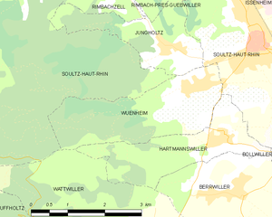
Wattwiller (Wattwiller)
- commune in Haut-Rhin, France
- Country:

- Postal Code: 68700
- Coordinates: 47° 50' 11" N, 7° 10' 48" E


- GPS tracks (wikiloc): [Link]
- Area: 13.61 sq km
- Population: 1656
- Web site: http://www.wattwiller.fr
- Wikipedia en: wiki(en)
- Wikipedia: wiki(fr)
- Wikidata storage: Wikidata: Q545447
- Wikipedia Commons Category: [Link]
- Freebase ID: [/m/03nsv88]
- Freebase ID: [/m/03nsv88]
- GeoNames ID: Alt: [2967420]
- GeoNames ID: Alt: [2967420]
- SIREN number: [216803593]
- SIREN number: [216803593]
- BnF ID: [15272061b]
- BnF ID: [15272061b]
- VIAF ID: Alt: [234330759]
- VIAF ID: Alt: [234330759]
- GND ID: Alt: [4559591-4]
- GND ID: Alt: [4559591-4]
- INSEE municipality code: 68359
- INSEE municipality code: 68359
Shares border with regions:


Hartmannswiller
- commune in Haut-Rhin, France
- Country:

- Postal Code: 68500
- Coordinates: 47° 51' 43" N, 7° 12' 57" E


- GPS tracks (wikiloc): [Link]
- Area: 4.78 sq km
- Population: 641


Berrwiller
- commune in Haut-Rhin, France
- Country:

- Postal Code: 68500
- Coordinates: 47° 50' 59" N, 7° 13' 9" E


- GPS tracks (wikiloc): [Link]
- Area: 7.66 sq km
- Population: 1183
- Web site: [Link]


Willer-sur-Thur
- commune in Haut-Rhin, France
- Country:

- Postal Code: 68760
- Coordinates: 47° 50' 37" N, 7° 4' 23" E


- GPS tracks (wikiloc): [Link]
- Area: 18 sq km
- Population: 1853


Uffholtz
- commune in Haut-Rhin, France
- Country:

- Postal Code: 68700
- Coordinates: 47° 49' 13" N, 7° 10' 44" E


- GPS tracks (wikiloc): [Link]
- Area: 11.91 sq km
- Population: 1701


Soultz-Haut-Rhin
- commune in Haut-Rhin, France
- Country:

- Postal Code: 68360
- Coordinates: 47° 53' 9" N, 7° 13' 45" E


- GPS tracks (wikiloc): [Link]
- Area: 29.56 sq km
- Population: 7150
- Web site: [Link]


Wuenheim
- commune in Haut-Rhin, France
- Country:

- Postal Code: 68500
- Coordinates: 47° 52' 23" N, 7° 12' 32" E


- GPS tracks (wikiloc): [Link]
- Area: 6.17 sq km
- Population: 793


Jungholtz
- commune in Haut-Rhin, France
- Country:

- Postal Code: 68500
- Coordinates: 47° 53' 7" N, 7° 11' 43" E


- GPS tracks (wikiloc): [Link]
- Area: 4 sq km
- Population: 909
