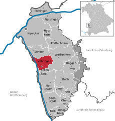
Weißenhorn (Weißenhorn)

- municipality of Germany
 Hiking in Weißenhorn
Weißenhorn is a picturesque town located in Bavaria, Germany, and it's known for its beautiful landscapes and access to various hiking trails. Hiking in and around Weißenhorn offers a chance to explore the scenic beauty of the Swabian region, with its rolling hills, forests, and farmlands. Here are some highlights to consider when hiking in Weißenhorn:
-
Trail Variety: There are numerous hiking trails suitable for different skill levels, from easy walks suitable for families to more challenging routes for experienced hikers. Be sure to check local maps or guides for trail information.
-
Natural Parks: The region is close to several natural parks and reserves, such as the Donauried and the nearby Swabian Jura (Schwäbische Alb), which offers extensive hiking opportunities with breathtaking views.
-
Cultural Sites: Many hiking routes in and around Weißenhorn will lead you to historical sites, including ancient castles, churches, and traditional Bavarian architecture. This makes for an enriching experience as you hike.
-
Seasonal Hiking: Depending on the season, the area offers different hiking experiences. In autumn, you can enjoy the stunning fall foliage, while spring brings flowers and vibrant greenery. Summer hiking can be a bit more challenging due to heat, so it’s important to stay hydrated.
-
Local Tips: Check local tourism websites or visitor centers for maps and recommended trails. It's also a good idea to inform someone of your hiking plans and ensure your phone is charged for emergencies.
-
Safety: As with any hiking activity, ensure you wear proper hiking shoes, dress according to the weather, and bring essential supplies, such as water, snacks, a first-aid kit, and a compass or GPS device.
Overall, hiking in Weißenhorn offers a delightful mix of nature, culture, and recreation, making it a perfect destination for outdoor enthusiasts.
- Country:

- Postal Code: 89264
- Local Dialing Code: 07306; 07309
- Licence Plate Code: NU
- Coordinates: 48° 18' 16" N, 10° 9' 33" E


- GPS tracks (wikiloc): [Link]
- AboveSeaLevel: 501 м m
- Area: 53.69 sq km
- Population: 13329
- Web site: http://www.weissenhorn.de
- Wikipedia en: wiki(en)
- Wikipedia: wiki(de)
- Wikidata storage: Wikidata: Q519677
- Wikipedia Commons Gallery: [Link]
- Wikipedia Commons Category: [Link]
- Freebase ID: [/m/08z55f]
- GeoNames ID: Alt: [2811879]
- VIAF ID: Alt: [141920049]
- OSM relation ID: [941081]
- GND ID: Alt: [4107923-1]
- archINFORM location ID: [5544]
- Library of Congress authority ID: Alt: [n82129192]
- MusicBrainz area ID: [2c3fbe88-168b-49e9-a2d7-e7f4383844a0]
- WOEID: [704965]
- Historical Gazetteer (GOV) ID: [WEIOR1JN58CH]
- Bavarikon ID: [ODB_A00000702]
- German municipality key: 09775164
Shares border with regions:
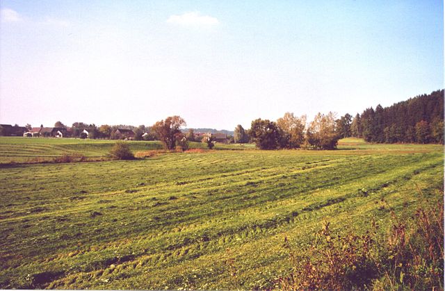
Stoffenrieder Forst
- unincorporated area in Germany
Hiking in Stoffenrieder Forst
Stoffenrieder Forst is a beautiful forested area located near Munich, Germany. It is known for its scenic landscapes, diverse flora and fauna, and well-maintained trails, making it a popular destination for both casual walkers and experienced hikers....
- Country:
- Coordinates: 48° 19' 0" N, 10° 14' 0" E
- GPS tracks (wikiloc): [Link]


Senden
- town in Bavaria, Germany
Hiking in Senden
Senden, located in North Rhine-Westphalia, Germany, may not be widely recognized as a major hiking destination, but it offers several opportunities for outdoor enthusiasts to explore nature. Here are some aspects to consider when hiking in and around Senden:...
- Country:
- Postal Code: 89250
- Local Dialing Code: 07309; 07307
- Licence Plate Code: NU
- Coordinates: 48° 19' 0" N, 10° 4' 0" E
- GPS tracks (wikiloc): [Link]
- AboveSeaLevel: 486 м m
- Area: 25.17 sq km
- Population: 19010
- Web site: [Link]


Illertissen
- municipality of Germany
Hiking in Illertissen
Illertissen, located in the Bavarian region of Germany, offers a variety of scenic hiking opportunities that are perfect for both beginners and experienced hikers. Here are some highlights and tips for hiking in and around Illertissen:...
- Country:
- Postal Code: 89257
- Local Dialing Code: 07303
- Coordinates: 48° 13' 0" N, 10° 5' 0" E
- GPS tracks (wikiloc): [Link]
- AboveSeaLevel: 513 м m
- Area: 36.45 sq km
- Population: 16694
- Web site: [Link]


Bellenberg
- municipality of Germany
Hiking in Bellenberg
Bellenberg is a quaint village in southern Germany, located near the city of Ulm in the state of Baden-Württemberg. Although not widely known as a hiking destination, it can serve as a good base for exploring the scenic trails in the surrounding region. Here are some key points to consider if you're interested in hiking in and around Bellenberg:...
- Country:
- Postal Code: 89287
- Local Dialing Code: 07306
- Licence Plate Code: NU
- Coordinates: 48° 15' 0" N, 10° 5' 0" E
- GPS tracks (wikiloc): [Link]
- AboveSeaLevel: 504 м m
- Area: 5.07 sq km
- Population: 3744
- Web site: [Link]


Buch
- municipality of Germany
Hiking in Buch
Buch in Swabia is a picturesque area known for its beautiful landscapes and plenty of opportunities for hiking. Located in the southern part of Germany, Buch offers hikers a chance to explore rolling hills, lush forests, and charming rural scenery. Here's what you should know about hiking in this area:...
- Country:
- Postal Code: 89290
- Local Dialing Code: 07343
- Licence Plate Code: NU
- Coordinates: 48° 13' 29" N, 10° 10' 50" E
- GPS tracks (wikiloc): [Link]
- AboveSeaLevel: 545 м m
- Area: 39.88 sq km
- Population: 3171
- Web site: [Link]

Vöhringen
- town in the district of Neu-Ulm, Bavaria, Germany
Hiking in Vöhringen
Vöhringen is a charming municipality located in Bavaria, Germany, offering various outdoor activities, including hiking. The region is characterized by its beautiful landscapes, including rolling hills, forests, and nearby rivers. Here are some highlights for hiking in and around Vöhringen:...
- Country:
- Postal Code: 89269
- Local Dialing Code: 07306
- Licence Plate Code: NU
- Coordinates: 48° 17' 0" N, 10° 5' 0" E
- GPS tracks (wikiloc): [Link]
- AboveSeaLevel: 499 м m
- Area: 23.63 sq km
- Population: 12168
- Web site: [Link]


Roggenburg
- municipality of Germany
Hiking in Roggenburg
Roggenburg is a picturesque village in Bavaria, Germany, known for its beautiful landscapes and outdoor activities, making it a great destination for hiking enthusiasts. The region offers a variety of trails that cater to different skill levels, from easy walks through scenic fields and forests to more challenging routes....
- Country:
- Postal Code: 89297
- Local Dialing Code: 07300
- Licence Plate Code: NU
- Coordinates: 48° 16' 36" N, 10° 13' 49" E
- GPS tracks (wikiloc): [Link]
- AboveSeaLevel: 596 м m
- Area: 27.41 sq km
- Population: 2259
- Web site: [Link]

Pfaffenhofen an der Roth
- municipality of Germany
Hiking in Pfaffenhofen an der Roth
Pfaffenhofen an der Roth, located in Bavaria, Germany, is surrounded by beautiful landscapes that make it an excellent spot for hiking enthusiasts. The region features a mix of forested pathways, rolling hills, and picturesque rural settings, ideal for hikers of all levels....
- Country:
- Postal Code: 89284
- Local Dialing Code: 07302
- Licence Plate Code: ILL; NU
- Coordinates: 48° 21' 16" N, 10° 9' 43" E
- GPS tracks (wikiloc): [Link]
- AboveSeaLevel: 489 м m
- Area: 42.66 sq km
- Population: 5897
- Web site: [Link]