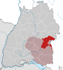
Neu-Ulm (Landkreis Neu-Ulm)

- district in Bavaria, Germany
 Hiking in Neu-Ulm
Neu-Ulm, located in Bavaria, Germany, offers several options for hiking enthusiasts. The region is known for its picturesque landscapes, combining rivers, hills, and forests. Here are some key points about hiking in Neu-Ulm:
Natural Attractions:
-
Danube River: The path along the Danube provides beautiful views and is perfect for leisurely walks or longer hikes. You can enjoy the serene environment and observe various flora and fauna along the riverbanks.
-
Nature Reserves: Areas around Neu-Ulm include nature reserves that offer hiking trails rich in biodiversity. The surrounding countryside features meadows, forests, and wetlands, giving hikers an opportunity to explore different ecosystems.
-
Ulm City Trails: The nearby town of Ulm features the well-known Ulm Cathedral and offers various hiking trails that connect to Neu-Ulm. You can hike along routes that traverse historical sites and provide insights into local culture.
Hiking Trails:
-
Ehinger Wald: This forested area has several well-marked trails that range from easy to moderate difficulty. It’s perfect for family hikes or those looking for a pleasant outing in nature.
-
Iller River Hikes: Trails alongside the Iller River are ideal for those looking to combine hiking with scenic views. The pathways are generally flat and suitable for all skill levels.
Tips for Hiking in Neu-Ulm:
-
Trail Maps: It’s helpful to have a trail map or a hiking app to navigate the marked trails. Local tourist information centers provide resources and tips on the best routes.
-
Weather Preparedness: Always check the weather forecast and dress appropriately. The area can experience rain, so bringing a lightweight waterproof jacket is advisable.
-
Safety Considerations: While most trails are well-maintained, it's important to remain on the marked paths and be cautious of wildlife. Carry enough water and snacks, especially for longer hikes.
-
Local Guides and Tours: If you're unfamiliar with the area, consider joining a local hiking group or tour. They can offer insights and help you discover hidden gems.
Hiking in Neu-Ulm provides a great way to explore the natural beauty and cultural heritage of the region. Whether you're an experienced hiker or a novice, there's something for everyone to enjoy!
- Country:

- Capital: Neu-Ulm
- Licence Plate Code: NU; ILL
- Coordinates: 48° 20' 0" N, 10° 10' 0" E


- GPS tracks (wikiloc): [Link]
- AboveSeaLevel: 474 м m
- Area: 515.00 sq km
- Population: 140666
- Web site: http://www.landkreis.neu-ulm.de
- Wikipedia en: wiki(en)
- Wikipedia: wiki(de)
- Wikidata storage: Wikidata: Q10410
- Wikipedia Commons Category: [Link]
- Freebase ID: [/m/024ttq]
- GeoNames ID: Alt: [3220887]
- VIAF ID: Alt: [157203137]
- OSM relation ID: [62469]
- GND ID: Alt: [4041988-5]
- archINFORM location ID: [2531]
- Library of Congress authority ID: Alt: [n87917567]
- TGN ID: [7077084]
- Bavarikon ID: [ODB_A00000685]
- NUTS code: [DE279]
- German district key: 09775
Includes regions:


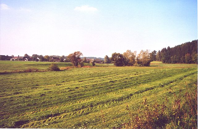
Auwald
- unincorporated area in Germany
Hiking in Auwald
Auwald, often known as floodplain forests or riparian forests, typically offers unique ecosystems dominated by water-loving trees and diverse wildlife. Although the term "Auwald" generally refers to these types of forests rather than a specific hiking area, many such regions provide excellent opportunities for outdoor adventures, especially in regions with well-marked trails....
- Country:
- Coordinates: 48° 15' 0" N, 10° 4' 0" E
- GPS tracks (wikiloc): [Link]
Unterroggenburger Wald
- unincorporated area in Germany
Hiking in Unterroggenburger Wald
Unterroggenburger Wald is a beautiful area known for its extensive forest trails and scenic landscapes. Located in Germany, it offers a variety of hiking options suitable for different skill levels. Here are some key points to consider when planning a hike in this area:...
- Country:
- Coordinates: 48° 15' 0" N, 10° 16' 0" E
- GPS tracks (wikiloc): [Link]
Stoffenrieder Forst
- unincorporated area in Germany
Hiking in Stoffenrieder Forst
Stoffenrieder Forst is a beautiful forested area located near Munich, Germany. It is known for its scenic landscapes, diverse flora and fauna, and well-maintained trails, making it a popular destination for both casual walkers and experienced hikers....
- Country:
- Coordinates: 48° 19' 0" N, 10° 14' 0" E
- GPS tracks (wikiloc): [Link]
Oberroggenburger Wald
- unincorporated area in Germany
Hiking in Oberroggenburger Wald
Oberroggenburger Wald, located in Germany, offers a picturesque setting for hikers looking to immerse themselves in nature. This area is characterized by lush forests, serene trails, and diverse wildlife. Here are some key points to consider if you're planning a hiking trip there:...
- Country:
- Coordinates: 48° 13' 0" N, 10° 15' 0" E
- GPS tracks (wikiloc): [Link]


Unterroth
- municipality of Germany
Hiking in Unterroth
Unterroth is a charming village located in Bavaria, Germany, known for its beautiful landscapes and outdoor recreational opportunities, making it a great destination for hiking enthusiasts. While specific marked trails may not be extensive in Unterroth itself, its location offers access to various scenic hiking routes in the surrounding area....
- Country:
- Postal Code: 89299
- Local Dialing Code: 07343
- Licence Plate Code: NU
- Coordinates: 48° 12' 0" N, 10° 10' 0" E
- GPS tracks (wikiloc): [Link]
- AboveSeaLevel: 524 м m
- Area: 15.37 sq km
- Population: 833
- Web site: [Link]


Osterberg
- municipality in Bavaria, Germany
Hiking in Osterberg
Osterberg, located in Germany, is a beautiful region offering various hiking opportunities for nature enthusiasts. The area is characterized by its stunning landscapes, diverse flora and fauna, and well-maintained trails. Here are some key points to consider when planning a hiking trip in Osterberg:...
- Country:
- Postal Code: 89296
- Local Dialing Code: 08333
- Licence Plate Code: NU
- Coordinates: 48° 9' 0" N, 10° 10' 0" E
- GPS tracks (wikiloc): [Link]
- AboveSeaLevel: 580 м m
- Area: 13.79 sq km
- Population: 767
- Web site: [Link]


Neu-Ulm
- town in Bavaria, Germany
Hiking in Neu-Ulm
Neu-Ulm, located in Bavaria, Germany, sits along the banks of the Danube River and offers a variety of hiking opportunities in the surrounding areas. While the city itself is more urban, the nearby countryside and natural landscapes provide excellent options for outdoor exploration. Here are a few highlights related to hiking in and around Neu-Ulm:...
- Country:
- Postal Code: 89231
- Local Dialing Code: 0731; 07308; 07307
- Licence Plate Code: NU
- Coordinates: 48° 23' 0" N, 10° 0' 0" E
- GPS tracks (wikiloc): [Link]
- AboveSeaLevel: 474 м m
- Area: 80.50 sq km
- Population: 57727
- Web site: [Link]
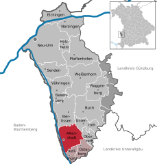
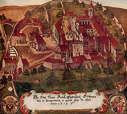
Altenstadt
- municpality in the district of Neu-Ulm, Bavaria, Germany
Hiking in Altenstadt
Altenstadt, located in Swabia, Germany, is an excellent destination for hiking enthusiasts, offering a variety of trails that cater to different experience levels. The region is known for its picturesque landscapes, including gentle hills, lush forests, and scenic views that reveal the charm of the Swabian countryside....
- Country:
- Postal Code: 89281
- Local Dialing Code: 08337
- Licence Plate Code: NU
- Coordinates: 48° 9' 37" N, 10° 6' 52" E
- GPS tracks (wikiloc): [Link]
- AboveSeaLevel: 528 м m
- Area: 31.30 sq km
- Population: 4208
- Web site: [Link]


Senden
- town in Bavaria, Germany
Hiking in Senden
Senden, located in North Rhine-Westphalia, Germany, may not be widely recognized as a major hiking destination, but it offers several opportunities for outdoor enthusiasts to explore nature. Here are some aspects to consider when hiking in and around Senden:...
- Country:
- Postal Code: 89250
- Local Dialing Code: 07309; 07307
- Licence Plate Code: NU
- Coordinates: 48° 19' 0" N, 10° 4' 0" E
- GPS tracks (wikiloc): [Link]
- AboveSeaLevel: 486 м m
- Area: 25.17 sq km
- Population: 19010
- Web site: [Link]
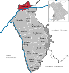
Elchingen
- municipality of Germany
Hiking in Elchingen
Elchingen, located in Bavaria, Germany, is a charming area known for its picturesque landscapes and outdoor activities, including hiking. The region is characterized by its rolling hills, lush forests, and scenic rivers, making it an attractive destination for nature enthusiasts....
- Country:
- Postal Code: 89081; 89275
- Local Dialing Code: 0731; 07308
- Licence Plate Code: ILL; NU
- Coordinates: 48° 27' 6" N, 10° 5' 52" E
- GPS tracks (wikiloc): [Link]
- AboveSeaLevel: 465 м m
- Area: 24.87 sq km
- Population: 9341
- Web site: [Link]


Illertissen
- municipality of Germany
Hiking in Illertissen
Illertissen, located in the Bavarian region of Germany, offers a variety of scenic hiking opportunities that are perfect for both beginners and experienced hikers. Here are some highlights and tips for hiking in and around Illertissen:...
- Country:
- Postal Code: 89257
- Local Dialing Code: 07303
- Coordinates: 48° 13' 0" N, 10° 5' 0" E
- GPS tracks (wikiloc): [Link]
- AboveSeaLevel: 513 м m
- Area: 36.45 sq km
- Population: 16694
- Web site: [Link]

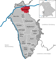
Nersingen
- municipality of Germany
Hiking in Nersingen
Nersingen is located in Bavaria, Germany, and is known for its beautiful landscapes and picturesque nature, making it a lovely spot for hiking enthusiasts. While there aren't extensive hiking trails specifically designated in Nersingen, you can find routes that connect to the surrounding areas, which offer a variety of hiking options....
- Country:
- Postal Code: 89278
- Local Dialing Code: 07308
- Licence Plate Code: ILL; NU
- Coordinates: 48° 25' 44" N, 10° 7' 19" E
- GPS tracks (wikiloc): [Link]
- AboveSeaLevel: 465 м m
- Area: 24.28 sq km
- Population: 9437
- Web site: [Link]

Kellmünz
- municipality of Germany
Hiking in Kellmünz
Kellmünz is a small town in Bavaria, Germany, known for its beautiful natural surroundings, making it a great destination for hiking enthusiasts. The region features scenic landscapes, with rolling hills, forests, and clear streams, providing a variety of hiking trails suitable for different skill levels....
- Country:
- Postal Code: 89293
- Local Dialing Code: 08337
- Licence Plate Code: NU
- Coordinates: 48° 7' 18" N, 10° 7' 41" E
- GPS tracks (wikiloc): [Link]
- AboveSeaLevel: 541 м m
- Area: 8.52 sq km
- Population: 1163
- Web site: [Link]


Bellenberg
- municipality of Germany
Hiking in Bellenberg
Bellenberg is a quaint village in southern Germany, located near the city of Ulm in the state of Baden-Württemberg. Although not widely known as a hiking destination, it can serve as a good base for exploring the scenic trails in the surrounding region. Here are some key points to consider if you're interested in hiking in and around Bellenberg:...
- Country:
- Postal Code: 89287
- Local Dialing Code: 07306
- Licence Plate Code: NU
- Coordinates: 48° 15' 0" N, 10° 5' 0" E
- GPS tracks (wikiloc): [Link]
- AboveSeaLevel: 504 м m
- Area: 5.07 sq km
- Population: 3744
- Web site: [Link]


Weißenhorn
- municipality of Germany
Hiking in Weißenhorn
Weißenhorn is a picturesque town located in Bavaria, Germany, and it's known for its beautiful landscapes and access to various hiking trails. Hiking in and around Weißenhorn offers a chance to explore the scenic beauty of the Swabian region, with its rolling hills, forests, and farmlands. Here are some highlights to consider when hiking in Weißenhorn:...
- Country:
- Postal Code: 89264
- Local Dialing Code: 07306; 07309
- Licence Plate Code: NU
- Coordinates: 48° 18' 16" N, 10° 9' 33" E
- GPS tracks (wikiloc): [Link]
- AboveSeaLevel: 501 м m
- Area: 53.69 sq km
- Population: 13329
- Web site: [Link]


Oberroth
- municipality of Germany
Hiking in Oberroth
Oberroth is a small village in Bavaria, Germany, situated in a picturesque area that's ideal for hiking enthusiasts. Its scenic landscapes, rolling hills, and nearby forests offer a variety of trails suited for all levels of hikers, from beginners to experienced trekkers. Here are some key points to consider when hiking in and around Oberroth:...
- Country:
- Postal Code: 89294
- Local Dialing Code: 08333
- Licence Plate Code: NU
- Coordinates: 48° 10' 0" N, 10° 11' 0" E
- GPS tracks (wikiloc): [Link]
- AboveSeaLevel: 534 м m
- Area: 9.94 sq km
- Population: 723
- Web site: [Link]


Holzheim
- town in Neu-Ulm District, Bavaria, Germany
Hiking in Holzheim
Holzheim, located in the Neu-Ulm district of Germany, offers beautiful landscapes and opportunities for outdoor activities, including hiking. While it may not be widely known as a hiking destination, the region is characterized by scenic trails that can be enjoyed by both beginners and experienced hikers....
- Country:
- Postal Code: 89291
- Local Dialing Code: 07302
- Licence Plate Code: ILL; NU
- Coordinates: 48° 23' 0" N, 10° 6' 0" E
- GPS tracks (wikiloc): [Link]
- AboveSeaLevel: 475 м m
- Area: 7.60 sq km
- Population: 1455
- Web site: [Link]


Buch
- municipality of Germany
Hiking in Buch
Buch in Swabia is a picturesque area known for its beautiful landscapes and plenty of opportunities for hiking. Located in the southern part of Germany, Buch offers hikers a chance to explore rolling hills, lush forests, and charming rural scenery. Here's what you should know about hiking in this area:...
- Country:
- Postal Code: 89290
- Local Dialing Code: 07343
- Licence Plate Code: NU
- Coordinates: 48° 13' 29" N, 10° 10' 50" E
- GPS tracks (wikiloc): [Link]
- AboveSeaLevel: 545 м m
- Area: 39.88 sq km
- Population: 3171
- Web site: [Link]

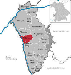
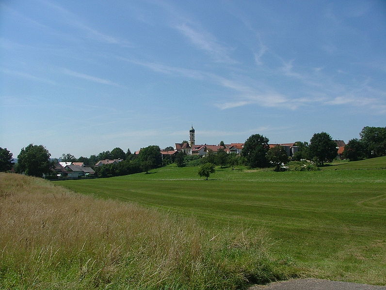
Vöhringen
- town in the district of Neu-Ulm, Bavaria, Germany
Hiking in Vöhringen
Vöhringen is a charming municipality located in Bavaria, Germany, offering various outdoor activities, including hiking. The region is characterized by its beautiful landscapes, including rolling hills, forests, and nearby rivers. Here are some highlights for hiking in and around Vöhringen:...
- Country:
- Postal Code: 89269
- Local Dialing Code: 07306
- Licence Plate Code: NU
- Coordinates: 48° 17' 0" N, 10° 5' 0" E
- GPS tracks (wikiloc): [Link]
- AboveSeaLevel: 499 м m
- Area: 23.63 sq km
- Population: 12168
- Web site: [Link]


Roggenburg
- municipality of Germany
Hiking in Roggenburg
Roggenburg is a picturesque village in Bavaria, Germany, known for its beautiful landscapes and outdoor activities, making it a great destination for hiking enthusiasts. The region offers a variety of trails that cater to different skill levels, from easy walks through scenic fields and forests to more challenging routes....
- Country:
- Postal Code: 89297
- Local Dialing Code: 07300
- Licence Plate Code: NU
- Coordinates: 48° 16' 36" N, 10° 13' 49" E
- GPS tracks (wikiloc): [Link]
- AboveSeaLevel: 596 м m
- Area: 27.41 sq km
- Population: 2259
- Web site: [Link]

Pfaffenhofen an der Roth
- municipality of Germany
Hiking in Pfaffenhofen an der Roth
Pfaffenhofen an der Roth, located in Bavaria, Germany, is surrounded by beautiful landscapes that make it an excellent spot for hiking enthusiasts. The region features a mix of forested pathways, rolling hills, and picturesque rural settings, ideal for hikers of all levels....
- Country:
- Postal Code: 89284
- Local Dialing Code: 07302
- Licence Plate Code: ILL; NU
- Coordinates: 48° 21' 16" N, 10° 9' 43" E
- GPS tracks (wikiloc): [Link]
- AboveSeaLevel: 489 м m
- Area: 42.66 sq km
- Population: 5897
- Web site: [Link]
Shares border with regions:

Unterallgäu
- district in Bavaria, Germany
Hiking in Unterallgäu
Unterallgäu is a beautiful region in Bavaria, Germany, known for its picturesque landscapes, charming villages, and extensive hiking trails. Located in the Allgäu, it's characterized by rolling hills, lush meadows, and stunning views of the Alpine foothills. Here are some highlights if you're considering hiking in Unterallgäu:...
- Country:
- Capital: Mindelheim
- Licence Plate Code: MN
- Coordinates: 48° 0' 0" N, 10° 30' 0" E
- GPS tracks (wikiloc): [Link]
- Area: 1230.24 sq km
- Population: 115770
- Web site: [Link]

Günzburg
- district in Bavaria, Germany
Hiking in Günzburg
Günzburg district, located in Bavaria, Germany, offers various hiking opportunities that showcase the beautiful landscapes of southern Germany. Here are some highlights about hiking in the area:...
- Country:
- Capital: Günzburg
- Licence Plate Code: KRU; GZ
- Coordinates: 48° 19' 48" N, 10° 19' 48" E
- GPS tracks (wikiloc): [Link]
- AboveSeaLevel: 537 м m
- Area: 763.00 sq km
- Population: 107120
- Web site: [Link]
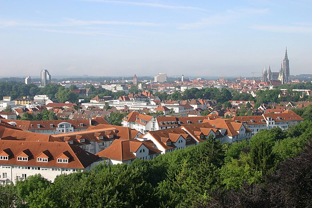

Ulm
- city in Baden-Württemberg
Hiking in Ulm
Ulm, located in the state of Baden-Württemberg in Germany, is not only rich in history and culture but also offers beautiful natural landscapes that are perfect for hiking enthusiasts. Here are some key points to consider when hiking in and around Ulm:...
- Country:
- Postal Code: 89079; 89077; 89075; 89073; 89081
- Local Dialing Code: 07305; 07346; 0731
- Licence Plate Code: UL
- Coordinates: 48° 23' 54" N, 9° 59' 30" E
- GPS tracks (wikiloc): [Link]
- AboveSeaLevel: 478 м m
- Area: 118.68 sq km
- Population: 123953
- Web site: [Link]
Alb-Donau-Kreis
- district in Baden-Württemberg, Germany
Hiking in Alb-Donau-Kreis
The Alb-Donau-Kreis is a beautiful district located in Baden-Württemberg, Germany, known for its diverse landscapes, rich nature, and historical sites. Hiking in this area offers a range of trails suitable for all levels of hikers, from beginners to more experienced trekkers. Here are some highlights and tips for hiking in Alb-Donau-Kreis:...
- Country:
- Capital: Ulm
- Licence Plate Code: UL
- Coordinates: 48° 24' 0" N, 9° 51' 0" E
- GPS tracks (wikiloc): [Link]
- AboveSeaLevel: 670 м m
- Area: 1358.67 sq km
- Population: 192104
- Web site: [Link]


Biberach district
- district in Baden-Württemberg, Germany
Hiking in Biberach district
Biberach district, located in Baden-Württemberg, Germany, is an excellent destination for hikers, offering a blend of picturesque landscapes, cultural heritage, and diverse trails suitable for all skill levels....
- Country:
- Capital: Biberach an der Riss
- Licence Plate Code: BC
- Coordinates: 48° 4' 48" N, 9° 49' 48" E
- GPS tracks (wikiloc): [Link]
- AboveSeaLevel: 581 м m
- Area: 1409.82 sq km
- Population: 194019
- Web site: [Link]