
Wiesbaden (Wiesbaden)


- capital of the German state of Hesse
 Hiking in Wiesbaden
Wiesbaden, the capital of the state of Hesse in Germany, offers a variety of hiking opportunities that cater to different skill levels and preferences. Nestled near the picturesque Rheingau region and surrounded by beautiful natural landscapes, it's an excellent destination for outdoor enthusiasts.
Key Hiking Areas and Trails
-
Nerotal Park: This park features a network of walking paths that provide a gentle introduction to hiking. The trails wind through beautiful gardens and offer views of the surrounding hills. It’s a great place for families and those looking for a leisurely hike.
-
Kellerstraße and the Wiesbaden Hills: An easily accessible trail that offers a moderate hike with rewarding views over Wiesbaden and the Rhine River. The Kellerstraße trail allows hikers to experience the lush greenery of the surrounding hills.
-
Vogelberg Nature Park: Located a short drive from Wiesbaden, this park features a range of trails that can be combined for longer hikes. The area is known for its rich biodiversity and beautiful landscapes, making it ideal for nature lovers.
-
Rheinsteig Trail: This long-distance hiking trail spans approximately 320 kilometers along the Rhine River from Bonn to Wiesbaden. The section near Wiesbaden offers stunning views of the river, vineyards, and charming villages. It's suitable for more experienced hikers looking for a challenge.
-
Taunus Mountains: Just a short distance from Wiesbaden, the Taunus Mountains provide a variety of hiking options, ranging from easy walks to more challenging treks. The Gothic ruins of the Altenberg castle and the lovely trails through the forest make it a popular choice.
Tips for Hiking in Wiesbaden
-
Weather Considerations: Be mindful of the weather, as it can change quickly. Always check forecasts before heading out and dress in layers.
-
Hydration and Snacks: Carry enough water and snacks, especially if you're planning on a longer hike. There may be limited facilities on some trails.
-
Trail Maps: Use a trail map or a hiking app to navigate the paths. While many trails are marked, it helps to have a backup just in case.
-
Respect Nature: Follow Leave No Trace principles to preserve the natural beauty of the area. Stay on marked trails and avoid disturbing wildlife.
-
Local Resources: Visit the Wiesbaden Tourist Information office for maps, trail guides, and current information about local hiking events or group hikes.
Hiking in Wiesbaden is an excellent way to enjoy the natural beauty of the region while getting some exercise. Whether you're an experienced hiker or just starting, you'll find trails that suit your needs.
- Country:

- Postal Code: 55252; 55246; 65183–65207
- Local Dialing Code: 611; 6134; 6127; 6122
- Licence Plate Code: WI
- Coordinates: 50° 4' 57" N, 8° 14' 24" E


- GPS tracks (wikiloc): [Link]
- AboveSeaLevel: 117 м m
- Area: 203.93 sq km
- Population: 277619
- Web site: https://www.wiesbaden.de/
- Wikipedia en: wiki(en)
- Wikipedia: wiki(de)
- Wikidata storage: Wikidata: Q1721
- Wikipedia Commons Gallery: [Link]
- Wikipedia Commons Category: [Link]
- Wikipedia Commons Maps Category: [Link]
- Freebase ID: [/m/0bp_7]
- GeoNames ID: Alt: [2809346]
- BnF ID: [11865892t]
- VIAF ID: Alt: [150068172]
- OSM relation ID: [62496]
- GND ID: Alt: [4066043-6]
- archINFORM location ID: [325]
- Library of Congress authority ID: Alt: [n50070589]
- PACTOLS thesaurus ID: [pcrt9gebwwKcnk]
- MusicBrainz area ID: [00ed07a5-acd7-4217-a37a-72ebf08349b6]
- WOEID: [706329]
- Quora topic ID: [Wiesbaden-Germany-2]
- SUDOC authorities ID: [026405644]
- Encyclopædia Britannica Online ID: [place/Wiesbaden]
- EMLO location ID: [4b25d79c-e87c-4927-8ecb-c9970aaef311]
- Facebook Places ID: [110497988970354]
- Great Russian Encyclopedia Online ID: [1916249]
- DMOZ ID: Alt: [Regional/Europe/Germany/States/Hesse/Localities/Wiesbaden/]
- National Library of Israel ID: [000971851]
- NUTS code: [DE714]
- Klexikon article ID: [Wiesbaden]
- FAST ID: [1202972]
- German municipality key: 06414000
- US National Archives Identifier: 10044945
- German district key: 06414
Includes regions:

Igstadt
- municipal district of the city of Wiesbaden in Hesse, Germany
Hiking in Igstadt
Igstadt, a district of Wiesbaden in Germany, is surrounded by beautiful natural landscapes, making it a great place for hiking enthusiasts. While the area itself may not have extensive hiking trails, it is strategically located near several hiking routes in the Hessian countryside....
- Country:
- Postal Code: 65207
- Coordinates: 50° 4' 50" N, 8° 19' 45" E
- GPS tracks (wikiloc): [Link]
- AboveSeaLevel: 206 м m
- Area: 7.26 sq km
Delkenheim
- municipal district of the city of Wiesbaden in Hesse, Germany
Hiking in Delkenheim
Wiesbaden-Delkenheim is a charming district located in the city of Wiesbaden, Germany. Nestled in the beautiful landscape of the Rhine Valley, it offers several opportunities for hiking, with scenic routes that provide both natural beauty and a glimpse into local culture....
- Country:
- Postal Code: 65205
- Coordinates: 50° 2' 49" N, 8° 21' 40" E
- GPS tracks (wikiloc): [Link]
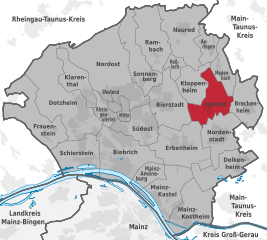
Kloppenheim
- municipal district of the city of Wiesbaden in Hesse, Germany
Hiking in Kloppenheim
Wiesbaden-Kloppenheim is an area situated in Germany, specifically within the state of Hesse. While it may not be as widely known as some of the larger hiking destinations, it can offer a unique and pleasant experience for those interested in exploring the local natural beauty and the surrounding landscapes....
- Country:
- Postal Code: 65207
- Coordinates: 50° 5' 40" N, 8° 18' 20" E
- GPS tracks (wikiloc): [Link]
- AboveSeaLevel: 196 м m
- Area: 5.39 sq km
Mainz-Amöneburg
- municipal district of the city of Wiesbaden in Hesse, Germany
Hiking in Mainz-Amöneburg
Hiking in Mainz-Amöneburg offers a wonderful experience for outdoor enthusiasts, combining scenic views, historical significance, and a variety of trails suitable for different skill levels. Here are some details to enhance your hiking adventure in this area:...
- Country:
- Postal Code: 65203
- Coordinates: 50° 2' 2" N, 8° 15' 6" E
- GPS tracks (wikiloc): [Link]
Auringen
- municipal district of the city of Wiesbaden in Hesse, Germany
Hiking in Auringen
Wiesbaden-Auringen, situated in the scenic region of Hesse, Germany, offers a delightful experience for hikers. This area is characterized by its lush greenery, rolling hills, and beautiful landscapes, making it ideal for outdoor enthusiasts....
- Country:
- Postal Code: 65207
- Coordinates: 50° 7' 22" N, 8° 19' 37" E
- GPS tracks (wikiloc): [Link]
Nordenstadt
- municipal district of the city of Wiesbaden in Hesse, Germany
Hiking in Nordenstadt
Wiesbaden-Nordenstadt, located in the state of Hesse, Germany, is a charming area that offers several hiking opportunities for outdoor enthusiasts. Here are some highlights and tips for hiking in this region:...
- Country:
- Postal Code: 65205
- Coordinates: 50° 4' 0" N, 8° 21' 0" E
- GPS tracks (wikiloc): [Link]
- AboveSeaLevel: 176 м m
- Population: 7896
Heßloch
- municipal district of the city of Wiesbaden in Hesse, Germany
Hiking in Heßloch
Wiesbaden-Heßloch is a picturesque area located in the Wiesbaden district of Germany, known for its beautiful landscapes and outdoor activities, including hiking. Here are some highlights and tips for hiking in this region:...
- Country:
- Postal Code: 65207
- Coordinates: 50° 6' 40" N, 8° 17' 45" E
- GPS tracks (wikiloc): [Link]
- AboveSeaLevel: 253 м m


Frauenstein
- municipal district of the city of Wiesbaden in Hesse, Germany
Hiking in Frauenstein
Wiesbaden-Frauenstein is a charming area that offers a variety of hiking opportunities, nestled in the scenic surroundings of the Taunus region in Germany. Here are some highlights to consider if you're planning a hike in this area:...
- Country:
- Postal Code: 65201
- Coordinates: 50° 3' 54" N, 8° 9' 14" E
- GPS tracks (wikiloc): [Link]
- AboveSeaLevel: 181 м m
- Area: 10.65 sq km
Sonnenberg
- municipal district of the city of Wiesbaden in Hesse, Germany
Hiking in Sonnenberg
Wiesbaden-Sonnenberg is a beautiful area located in the hills surrounding Wiesbaden, Germany. This region is known for its picturesque landscapes, lush forests, and scenic views of the Rhine Valley. Hiking in this area can be a rewarding experience for both beginners and seasoned hikers....
- Country:
- Postal Code: 65193; 65191
- Coordinates: 50° 6' 7" N, 8° 15' 53" E
- GPS tracks (wikiloc): [Link]
- AboveSeaLevel: 242 м m
- Area: 8.34 sq km
Breckenheim
- municipal district of the city of Wiesbaden in Hesse, Germany
Hiking in Breckenheim
Wiesbaden-Breckenheim, located in the state of Hesse, Germany, offers a variety of scenic hiking opportunities that highlight the natural beauty of the region. Here are some key points to consider when hiking in and around Breckenheim:...
- Country:
- Postal Code: 65207
- Coordinates: 50° 4' 0" N, 8° 22' 0" E
- GPS tracks (wikiloc): [Link]
- AboveSeaLevel: 167 м m
- Population: 3572


Schierstein
- municipal district of the city of Wiesbaden in Hesse, Germany
Hiking in Schierstein
Schierstein, located in the Wiesbaden district of Germany, offers beautiful hiking opportunities primarily around the scenic landscapes along the Rhine River, as well as paths that meander through nearby vineyards and forests. Here are some highlights for hiking in and around Schierstein:...
- Country:
- Postal Code: 65201
- Coordinates: 50° 2' 40" N, 8° 11' 50" E
- GPS tracks (wikiloc): [Link]
- AboveSeaLevel: 94 м m
- Area: 9.43 sq km
Mainz-Kostheim
- municipal district of the city of Wiesbaden in Hesse, Germany
Hiking in Mainz-Kostheim
Mainz-Kostheim is a lovely area located in the southern part of Mainz, Germany. It is often appreciated for its scenic beauty and accessibility for those looking to enjoy hiking and outdoor activities. Here are some highlights about hiking in and around Mainz-Kostheim:...
- Country:
- Postal Code: 55246
- Coordinates: 50° 0' 10" N, 8° 18' 20" E
- GPS tracks (wikiloc): [Link]
- AboveSeaLevel: 89 м m
- Population: 13968

Rheingauviertel
- borough of the city of Wiesbaden in Hesse, Germany
Hiking in Rheingauviertel
Wiesbaden-Rheingauviertel is located in the picturesque Rheingau region, which is well known for its beautiful landscapes, vineyards, and the scenic Rhine River. This area offers various hiking opportunities, often featuring well-marked trails that cater to different skill levels....
- Country:
- Postal Code: 65197; 65195; 65187; 65185
- Coordinates: 50° 4' 32" N, 8° 13' 36" E
- GPS tracks (wikiloc): [Link]
- Area: 2.47 sq km
Bierstadt
- municipal district of the city of Wiesbaden in Hesse, Germany
Hiking in Bierstadt
Bierstadt is a beautiful area located in the Rocky Mountain National Park, named after the 19th-century landscape painter Albert Bierstadt. It offers a range of hiking trails that cater to different skill levels, showcasing stunning views of the mountains, alpine lakes, and diverse wildlife....
- Country:
- Postal Code: 65191
- Coordinates: 50° 5' 0" N, 8° 17' 0" E
- GPS tracks (wikiloc): [Link]
- AboveSeaLevel: 186 м m
- Area: 9.22 sq km
- Population: 12304
Erbenheim
- municipal district of the city of Wiesbaden in Hesse, Germany
Hiking in Erbenheim
Wiesbaden-Erbenheim is a charming area located in the outskirts of Wiesbaden, Germany. If you're considering hiking in and around this region, here are some things to keep in mind:...
- Country:
- Postal Code: 65205
- Coordinates: 50° 3' 0" N, 8° 18' 0" E
- GPS tracks (wikiloc): [Link]
- AboveSeaLevel: 150 м m
- Area: 11.27 sq km
Klarenthal
- municipal district of the city of Wiesbaden in Hesse, Germany
Hiking in Klarenthal
Klarenthal, located in Germany, is an area that offers a range of hiking opportunities due to its picturesque landscapes and natural beauty. While the specifics may vary depending on the time of year and local conditions, here are some general insights into hiking in the Klarenthal area:...
- Country:
- Postal Code: 65197
- Coordinates: 50° 5' 15" N, 8° 11' 55" E
- GPS tracks (wikiloc): [Link]
- AboveSeaLevel: 191 м m
- Area: 6.13 sq km
Mainz-Kastel
- municipal district of the city of Wiesbaden in Hesse, Germany
Hiking in Mainz-Kastel
Mainz-Kastel, located in the city of Wiesbaden in Germany, is a charming area with access to various hiking opportunities. While it may not be surrounded by extensive wilderness like some other regions in Germany, there are still several trails and pathways where you can enjoy the natural beauty and landscapes of the Rhine Valley....
- Country:
- Postal Code: 55252
- Coordinates: 50° 0' 35" N, 8° 17' 4" E
- GPS tracks (wikiloc): [Link]
- AboveSeaLevel: 90 м m

Dotzheim
- municipal district of the city of Wiesbaden in Hesse, Germany
Hiking in Dotzheim
Wiesbaden-Dotzheim, a district in Wiesbaden, Germany, offers a variety of hiking opportunities that showcase the natural beauty of the surrounding area, including scenic views, forests, and rolling hills. Here are some highlights and tips for hiking in the region:...
- Country:
- Postal Code: 65201; 65199
- Coordinates: 50° 4' 23" N, 8° 11' 37" E
- GPS tracks (wikiloc): [Link]
- AboveSeaLevel: 179 м m
- Area: 18.27 sq km
- Population: 26109


Nordost
- borough of the city of Wiesbaden in Hesse, Germany
Hiking in Nordost
Wiesbaden-Nordost is a beautiful area within the city of Wiesbaden, Germany, known for its scenic landscapes, natural beauty, and well-maintained trails. While it may not be as extensive as larger national parks, the region offers several options for hiking enthusiasts....
- Country:
- Postal Code: 65195; 65193; 65191
- Coordinates: 50° 5' 30" N, 8° 13' 50" E
- GPS tracks (wikiloc): [Link]
- Area: 19.44 sq km

Südost
- borough of the city of Wiesbaden in Hesse, Germany
Hiking in Südost
Wiesbaden-Südost offers a fantastic opportunity for hikers, blending natural beauty with scenic trails. Located in the state of Hesse, Germany, this area is characterized by its gentle rolling hills, lush woodlands, and picturesque landscapes. Here are some highlights for hiking in Wiesbaden-Südost:...
- Country:
- Postal Code: 65189; 65187
- Coordinates: 50° 4' 1" N, 8° 14' 59" E
- GPS tracks (wikiloc): [Link]
- Area: 6.62 sq km


Biebrich
- municipal district of the city of Wiesbaden in Hesse, Germany
Hiking in Biebrich
Biebrich is a district in Wiesbaden, Germany, located by the banks of the Rhine River. While it may not be a destination known for extensive hiking trails, it offers beautiful scenic views and some lovely walking routes along the river and through nearby parks....
- Country:
- Postal Code: 65203
- Coordinates: 50° 2' 51" N, 8° 14' 27" E
- GPS tracks (wikiloc): [Link]
- Area: 12.99 sq km


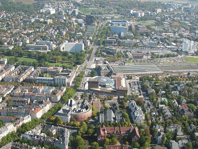
Mitte
- borough of the city of Wiesbaden in Hesse, Germany
Hiking in Mitte
Wiesbaden-Mitte, located in the heart of Wiesbaden, Germany, is not typically known for extensive hiking trails since it's more urban, but there are still some great opportunities for outdoor enthusiasts nearby. If you’re looking to hike in and around Wiesbaden, here are some aspects to consider:...
- Country:
- Postal Code: 65193; 65185; 65183
- Coordinates: 50° 4' 54" N, 8° 14' 28" E
- GPS tracks (wikiloc): [Link]
- Area: 1.53 sq km

Westend
- borough of the city of Wiesbaden in Hesse, Germany
Hiking in Westend
Wiesbaden-Westend is a charming district in the city of Wiesbaden, Germany, located close to the picturesque landscapes of the surrounding region. While Westend itself is primarily a residential area, it offers access to various hiking opportunities nearby, particularly in the surrounding hills and parks....
- Country:
- Postal Code: 65183
- Coordinates: 50° 4' 49" N, 8° 13' 46" E
- GPS tracks (wikiloc): [Link]
- Area: 0.67 sq km
Medenbach
- municipal district of the city of Wiesbaden in Hesse, Germany
Hiking in Medenbach
Wiesbaden-Medenbach is a charming district located on the outskirts of Wiesbaden, Germany, and offers several opportunities for hiking enthusiasts. Here are some key points to consider if you're planning a hiking adventure in the area:...
- Country:
- Postal Code: 65207
- Coordinates: 50° 6' 34" N, 8° 20' 19" E
- GPS tracks (wikiloc): [Link]
Naurod
- municipal district of the city of Wiesbaden in Hesse, Germany
Hiking in Naurod
Wiesbaden-Naurod is a charming district located on the outskirts of Wiesbaden, Germany. The area offers several hiking opportunities, mainly characterized by picturesque landscapes, beautiful vineyards, and forest trails. Here are some highlights and tips for hiking in this region:...
- Country:
- Postal Code: 65207
- Coordinates: 50° 8' 5" N, 8° 18' 5" E
- GPS tracks (wikiloc): [Link]
Rambach
- municipal district of the city of Wiesbaden in Hesse, Germany
Hiking in Rambach
Wiesbaden-Rambach, located in the beautiful state of Hesse in Germany, is a fantastic area for hiking enthusiasts. This district of Wiesbaden features a mix of scenic landscapes, including woodlands, meadows, and views of the surrounding hills. Here’s what you can expect when hiking in this area:...
- Country:
- Postal Code: 65207
- Coordinates: 50° 7' 0" N, 8° 16' 28" E
- GPS tracks (wikiloc): [Link]
Shares border with regions:


Mainz
- capital of the German state of Rhineland-Palatinate, Germany
Hiking in Mainz
Mainz, the capital of the Rhineland-Palatinate region in Germany, offers a variety of hiking opportunities, both within the city and in the surrounding countryside. Here are some aspects to consider when hiking in and around Mainz:...
- Country:
- Postal Code: 55001–55131
- Local Dialing Code: 06136; 06131
- Licence Plate Code: MZ
- Coordinates: 50° 0' 0" N, 8° 16' 0" E
- GPS tracks (wikiloc): [Link]
- AboveSeaLevel: 89 м m
- Area: 97.73 sq km
- Population: 213528
- Web site: [Link]


Rheingau-Taunus-Kreis
- district in Hesse, Germany
Hiking in Rheingau-Taunus-Kreis
The Rheingau-Taunus-Kreis region in Germany is an excellent destination for hiking enthusiasts, offering a diverse landscape that includes rolling hills, vineyards, and dense forests. Located in the state of Hesse, this area is known for its natural beauty and cultural significance, making it a great spot for both experienced hikers and those new to the activity....
- Country:
- Capital: Bad Schwalbach
- Licence Plate Code: RÜD
- Coordinates: 50° 8' 54" N, 8° 4' 24" E
- GPS tracks (wikiloc): [Link]
- AboveSeaLevel: 308 м m
- Web site: [Link]


Main-Taunus-Kreis
- district in Hesse, Germany
Hiking in Main-Taunus-Kreis
Main-Taunus-Kreis, located in Hesse, Germany, is a beautiful area known for its picturesque landscapes, including the Taunus mountains. Hiking in this region can be a rewarding experience, offering a mix of nature, history, and outdoor activities....
- Country:
- Capital: Hofheim am Taunus
- Licence Plate Code: MTK
- Coordinates: 50° 4' 46" N, 8° 26' 58" E
- GPS tracks (wikiloc): [Link]
- AboveSeaLevel: 245 м m
- Area: 222.40 sq km
- Population: 226113
- Web site: [Link]


Groß-Gerau
- district in Hesse, Germany
Hiking in Groß-Gerau
Groß-Gerau is a district in the state of Hesse, Germany, located just south of Frankfurt. While it may not be as well-known for hiking as some other regions in Germany, it offers a variety of scenic routes that showcase the natural beauty of the area....
- Country:
- Capital: Groß-Gerau
- Licence Plate Code: GG
- Coordinates: 49° 54' 46" N, 8° 28' 42" E
- GPS tracks (wikiloc): [Link]
- AboveSeaLevel: 87 м m
- Area: 453.05 sq km
- Population: 254883
- Web site: [Link]
Mainz-Bingen
- district of Rhineland-Palatinate, Germany
Hiking in Mainz-Bingen
Mainz-Bingen, situated in the scenic Rhineland-Palatinate region of Germany, is an excellent destination for hiking enthusiasts. The area boasts a mix of beautiful landscapes, including vineyards, hills, rivers, and charming villages, making it a great place for both casual walkers and serious hikers....
- Country:
- Licence Plate Code: MZ; BIN
- Coordinates: 49° 55' 12" N, 8° 4' 48" E
- GPS tracks (wikiloc): [Link]
- AboveSeaLevel: 201 м m
- Area: 605.85 sq km
- Population: 202222
- Web site: [Link]