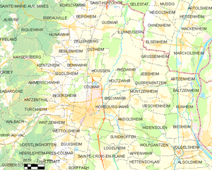
Wintzenheim (Wintzenheim)

- commune in Haut-Rhin, France
- Country:

- Postal Code: 68920
- Coordinates: 48° 4' 23" N, 7° 17' 24" E


- GPS tracks (wikiloc): [Link]
- Area: 18.97 sq km
- Population: 7535
- Web site: http://www.ville-wintzenheim.fr
- Wikipedia en: wiki(en)
- Wikipedia: wiki(fr)
- Wikidata storage: Wikidata: Q495481
- Wikipedia Commons Category: [Link]
- Freebase ID: [/m/03m4911]
- Freebase ID: [/m/03m4911]
- GeoNames ID: Alt: [2967337]
- GeoNames ID: Alt: [2967337]
- SIREN number: [216803742]
- SIREN number: [216803742]
- BnF ID: [15272076c]
- BnF ID: [15272076c]
- VIAF ID: Alt: [133890386]
- VIAF ID: Alt: [133890386]
- GND ID: Alt: [4520630-2]
- GND ID: Alt: [4520630-2]
- Library of Congress authority ID: Alt: [n2003006543]
- Library of Congress authority ID: Alt: [n2003006543]
- INSEE municipality code: 68374
- INSEE municipality code: 68374
Shares border with regions:

Colmar
- commune in Haut-Rhin, France
- Country:
- Postal Code: 68000
- Local Dialing Code: 389
- Coordinates: 48° 4' 52" N, 7° 21' 18" E
- GPS tracks (wikiloc): [Link]
- AboveSeaLevel: 197 м m
- Area: 66.57 sq km
- Population: 70284
- Web site: [Link]


Walbach
- commune in Haut-Rhin, France
- Country:
- Postal Code: 68230
- Coordinates: 48° 3' 44" N, 7° 13' 23" E
- GPS tracks (wikiloc): [Link]
- Area: 5.45 sq km
- Population: 893
- Web site: [Link]

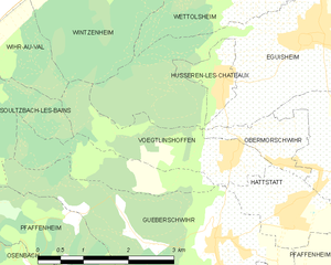
Voegtlinshoffen
- commune in Haut-Rhin, France
- Country:
- Postal Code: 68420
- Coordinates: 48° 1' 15" N, 7° 16' 52" E
- GPS tracks (wikiloc): [Link]
- AboveSeaLevel: 340 м m
- Area: 3.99 sq km
- Population: 519

Turckheim
- commune in Haut-Rhin, France
- Country:
- Postal Code: 68230
- Coordinates: 48° 5' 11" N, 7° 16' 50" E
- GPS tracks (wikiloc): [Link]
- Area: 16.46 sq km
- Population: 3759
- Web site: [Link]


Zimmerbach
- commune in Haut-Rhin, France
- Country:
- Postal Code: 68230
- Coordinates: 48° 4' 22" N, 7° 14' 13" E
- GPS tracks (wikiloc): [Link]
- Area: 2.26 sq km
- Population: 852


Eguisheim
- commune in Haut-Rhin, France
- Country:
- Postal Code: 68420
- Local Dialing Code: 389
- Coordinates: 48° 2' 35" N, 7° 18' 21" E
- GPS tracks (wikiloc): [Link]
- Area: 14.13 sq km
- Population: 1734
- Web site: [Link]


Ingersheim
- commune in Haut-Rhin, France
- Country:
- Postal Code: 68040
- Coordinates: 48° 5' 41" N, 7° 18' 23" E
- GPS tracks (wikiloc): [Link]
- AboveSeaLevel: 196.326 м m
- Area: 7.44 sq km
- Population: 4641
- Web site: [Link]

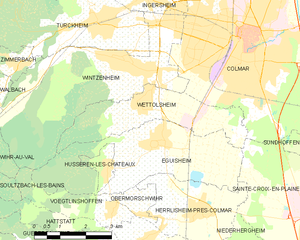
Wettolsheim
- commune in Haut-Rhin, France
- Country:
- Postal Code: 68920
- Coordinates: 48° 3' 25" N, 7° 17' 58" E
- GPS tracks (wikiloc): [Link]
- Area: 8.86 sq km
- Population: 1703


Wihr-au-Val
- commune in Haut-Rhin, France
- Country:
- Postal Code: 68230
- Coordinates: 48° 3' 12" N, 7° 12' 20" E
- GPS tracks (wikiloc): [Link]
- Area: 12.54 sq km
- Population: 1269