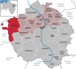
Wriedel (Wriedel)
- Municipality in Germany
Wriedel, a charming village located in the Lower Saxony region of Germany, is surrounded by beautiful natural landscapes that make it an appealing destination for hiking enthusiasts. While Wriedel itself may not be a well-known hiking hotspot, the surrounding areas offer various trails and opportunities to enjoy the great outdoors.
Here are some tips and highlights for hiking around Wriedel:
-
Nature Reserves: The region is home to several nature reserves and parks, providing a scenic backdrop for hiking. Look for trails that explore local flora and fauna.
-
Trail Options: You can find a range of trails suitable for different skill levels. Whether you’re looking for a leisurely walk or a more challenging hike, there's likely a path that fits your needs.
-
Local Information: Before heading out, consider visiting local tourist information centers for maps and recommendations on the best hiking trails in the area.
-
Historical Sites: Many hiking routes may lead to historical landmarks or points of interest, so keep an eye out for signs or information about local history.
-
Seasonal Considerations: Always check the weather before heading out, as conditions can change quickly. In spring and summer, the vibrant flora is stunning, while autumn offers beautiful foliage.
-
Wildlife Watching: Bring binoculars if you're interested in birdwatching or spotting local wildlife along your hike.
-
Safety Tips: Always let someone know your hiking plans, carry enough water, and wear appropriate footwear to ensure a safe and enjoyable experience.
Overall, while Wriedel itself may be a lesser-known gem, the surrounding natural beauty provides an excellent opportunity for hiking and enjoying outdoor activities.
- Country:

- Postal Code: 29565
- Local Dialing Code: 05829
- Licence Plate Code: UE
- Coordinates: 53° 2' 0" N, 10° 19' 0" E


- GPS tracks (wikiloc): [Link]
- AboveSeaLevel: 64 м m
- Area: 104.15 sq km
- Population: 2398
- Web site: http://www.wriedel.de
- Wikipedia en: wiki(en)
- Wikipedia: wiki(de)
- Wikidata storage: Wikidata: Q696316
- Wikipedia Commons Category: [Link]
- Freebase ID: [/m/02r_jhv]
- Freebase ID: [/m/02r_jhv]
- GeoNames ID: Alt: [2806002]
- GeoNames ID: Alt: [2806002]
- VIAF ID: Alt: [242731271]
- VIAF ID: Alt: [242731271]
- OSM relation ID: [1460240]
- OSM relation ID: [1460240]
- GND ID: Alt: [4516800-3]
- GND ID: Alt: [4516800-3]
- German municipality key: 03360029
- German municipality key: 03360029
Shares border with regions:


Munster, Lower Saxony
- municipality of Germany
 Hiking in Munster, Lower Saxony
Munster, Lower Saxony, is surrounded by beautiful landscapes that offer a variety of hiking opportunities for enthusiasts of all levels. The region features a mix of scenic countryside, forested areas, and picturesque villages, making it an ideal destination for hiking....
- Country:

- Postal Code: 29633
- Local Dialing Code: 05192
- Licence Plate Code: HK
- Coordinates: 52° 59' 19" N, 10° 5' 28" E


- GPS tracks (wikiloc): [Link]
- AboveSeaLevel: 73 м m
- Area: 193.42 sq km
- Population: 14958
- Web site: [Link]
