
Wuppertal (Wuppertal)


- city in North Rhine-Westphalia, Germany
 Hiking in Wuppertal
Wuppertal, located in North Rhine-Westphalia, Germany, offers some unique hiking opportunities, particularly due to its hilly landscape and green spaces. While Wuppertal is more famous for its iconic suspension railway, it also has beautiful trails that cater to different skill levels.
Hiking Areas and Trails:
-
Südhöhen: This area features numerous trails with varied difficulty levels and offers stunning views of the city and surrounding nature. The paths range from easy walks to more challenging hikes.
-
Wuppertal Arboretum: A great spot for leisurely hikes, this botanical garden features an extensive collection of trees and plants. It’s perfect for nature lovers and families looking for a gentle stroll.
-
Wupper River: Following the Wupper River is a picturesque way to hike. The riverbanks have well-maintained paths that allow for idyllic walking conditions, intertwined with scenic nature.
-
The Nordbahntrasse: This former railway line has been transformed into a cycle and walking path, running from Wuppertal to Velbert. It provides a flat and easy route, ideal for families and casual hikers.
-
Hardt Park: Located in the center of Wuppertal, Hardt Park offers walking trails along with beautiful gardens. The park is a serene place for walks amidst well-kept natural surroundings.
Tips for Hiking in Wuppertal:
- Proper Footwear: Ensure you wear comfortable hiking shoes, as some trails can be steep or uneven.
- Weather Preparedness: The weather can change quickly, so check forecasts and dress in layers.
- Hydration and Snacks: Carry water and light snacks, especially for longer hikes.
- Local Maps: Pick up local maps at tourist information centers, which can provide details on trail lengths, difficulty, and sights.
- Respect Nature: Stay on marked paths and be aware of the local wildlife.
Duration and Accessibility:
Hiking routes in Wuppertal can range from short (1-2 hours) to full-day treks, depending on your choice. The trails are generally accessible via public transport, making it easy to reach starting points.
Conclusion:
Wuppertal may not be a renowned hiking destination, but it offers a charming mix of urban and natural landscapes perfect for day hikes. Whether you're a seasoned hiker or a casual walker, you can enjoy the scenic beauty and tranquility the region has to offer.
- Country:

- Postal Code: 42001–42399
- Local Dialing Code: 02053; 02058; 0202
- Licence Plate Code: W
- Coordinates: 51° 15' 38" N, 7° 10' 22" E


- GPS tracks (wikiloc): [Link]
- AboveSeaLevel: 157 м m
- Area: 168.39 sq km
- Population: 352390
- Web site: https://www.wuppertal.de/
- Wikipedia en: wiki(en)
- Wikipedia: wiki(de)
- Wikidata storage: Wikidata: Q2107
- Wikipedia Commons Gallery: [Link]
- Wikipedia Commons Category: [Link]
- Wikipedia Commons Maps Category: [Link]
- Freebase ID: [/m/0d3ff]
- GeoNames ID: Alt: [6553031]
- BnF ID: [119748412]
- VIAF ID: Alt: [155144514]
- OSM relation ID: [62478]
- GND ID: Alt: [4067084-3]
- archINFORM location ID: [421]
- Library of Congress authority ID: Alt: [n81071986]
- MusicBrainz area ID: [5f226492-2ff6-4ea3-8c04-e8d9c4de2a49]
- WOEID: [708228]
- Quora topic ID: [Wuppertal-Germany]
- Encyclopædia Britannica Online ID: [place/Wuppertal]
- Gran Enciclopèdia Catalana ID: [0072448]
- EMLO location ID: [5e998de3-fc63-49c2-8ee5-2785067ada53]
- Great Russian Encyclopedia Online ID: [2335838]
- DMOZ ID: Alt: [Regional/Europe/Germany/States/North_Rhine-Westphalia/Localities/Wuppertal/]
- National Library of Israel ID: [000985858]
- NUTS code: [DEA1A]
- Klexikon article ID: [Wuppertal]
- Open Library subject ID: [place:wuppertal]
- German municipality key: 05124000
- German district key: 05124
Includes regions:
Langerfeld-Beyenburg
- human settlement in Germany
Hiking in Langerfeld-Beyenburg
Langerfeld-Beyenburg is a picturesque area located in the outskirts of Wuppertal, North Rhine-Westphalia, Germany. It offers a charming blend of natural beauty, historical sites, and well-marked hiking trails, making it a great destination for outdoor enthusiasts....
- Country:
- Coordinates: 51° 15' 15" N, 7° 15' 49" E
- GPS tracks (wikiloc): [Link]
- Area: 29.40 sq km
Heckinghausen
- human settlement in Germany
Hiking in Heckinghausen
Heckinghausen, a district located in Wuppertal, Germany, offers some pleasant hiking opportunities that take advantage of the area's natural beauty and scenic landscapes. Here are some key points to consider if you're planning a hike in Heckinghausen:...
- Country:
- Coordinates: 51° 16' 13" N, 7° 13' 17" E
- GPS tracks (wikiloc): [Link]
- Area: 5.66 sq km
Elberfeld
- human settlement in Germany
Hiking in Elberfeld
Elberfeld is a district in the city of Wuppertal, North Rhine-Westphalia, Germany. While it might not be the first place that comes to mind for hiking, there are definitely some outdoor opportunities that extend to the surrounding areas....
- Country:
- Coordinates: 51° 15' 26" N, 7° 8' 57" E
- GPS tracks (wikiloc): [Link]
- Area: 11.07 sq km
Elberfeld-West
- human settlement in Germany
Hiking in Elberfeld-West
Elberfeld-West is a district in Wuppertal, Germany, and while it may not be as well-known for hiking as some of the surrounding natural areas, there are still opportunities for outdoor activities and enjoying nature in and around this region....
- Country:
- Local Dialing Code: 0202
- Coordinates: 51° 15' 8" N, 7° 6' 39" E
- GPS tracks (wikiloc): [Link]
- Area: 10.37 sq km
- Population: 27478
Barmen
- district of Wuppertal, North Rhine-Westphalia, Germany
Hiking in Barmen
Barmen, a district of Wuppertal in North Rhine-Westphalia, Germany, is known for its beautiful landscapes and access to nature, making it a great spot for hiking enthusiasts. Here are some highlights and tips for hiking in and around Barmen:...
- Country:
- Coordinates: 51° 16' 10" N, 7° 11' 30" E
- GPS tracks (wikiloc): [Link]
- Area: 15.44 sq km
Uellendahl-Katernberg
- human settlement in Germany
Hiking in Uellendahl-Katernberg
Uellendahl-Katernberg is a district located in Wuppertal, Germany, known for its picturesque landscapes and natural beauty. Although it may not be as renowned as some major hiking destinations, it offers a variety of trails and outdoor experiences for both novice and experienced hikers. Here are some highlights for hiking in Uellendahl-Katernberg:...
- Country:
- Coordinates: 51° 16' 50" N, 7° 7' 25" E
- GPS tracks (wikiloc): [Link]
- Area: 25.91 sq km
Oberbarmen
- human settlement in Germany
Hiking in Oberbarmen
Oberbarmen is a district in the city of Wuppertal, Germany. While it may not be as famous as some other hiking destinations, it does offer some beautiful outdoor experiences, particularly in the surrounding areas. Here are some key points to consider if you're planning to hike in and around Oberbarmen:...
- Country:
- Coordinates: 51° 17' 4" N, 7° 13' 21" E
- GPS tracks (wikiloc): [Link]
- Area: 12.57 sq km
Vohwinkel
- human settlement in Germany
Hiking in Vohwinkel
Vohwinkel is a district located in the city of Wuppertal, Germany. While Vohwinkel itself may not be widely recognized as a major hiking destination, it does offer access to some scenic spots and trails in the surrounding region. Here are a few points to consider if you're interested in hiking in and around Vohwinkel:...
- Country:
- Coordinates: 51° 13' 52" N, 7° 4' 12" E
- GPS tracks (wikiloc): [Link]
- Area: 20.42 sq km
- Population: 30504
Ronsdorf
- human settlement in Germany
Hiking in Ronsdorf
Ronsdorf is a charming district located in the city of Wuppertal in North Rhine-Westphalia, Germany. It's known for its picturesque landscapes, which provide an excellent backdrop for hiking enthusiasts....
- Country:
- Coordinates: 51° 14' 0" N, 7° 12' 0" E
- GPS tracks (wikiloc): [Link]
- Area: 16.05 sq km
Cronenberg, Wuppertal
- human settlement in Germany
Hiking in Cronenberg, Wuppertal
Cronenberg is a beautiful district in Wuppertal, Germany, known for its picturesque landscapes and great hiking opportunities. Here are some highlights for hiking in the area:...
- Country:
- Coordinates: 51° 12' 21" N, 7° 7' 44" E
- GPS tracks (wikiloc): [Link]
- Area: 21.50 sq km
Shares border with regions:


Ennepe-Ruhr-Kreis
- district in North Rhine-Westphalia, Germany
Hiking in Ennepe-Ruhr-Kreis
Ennepe-Ruhr-Kreis, located in North Rhine-Westphalia, Germany, is an excellent destination for hiking enthusiasts. The region is characterized by its diverse landscapes, which include forests, hills, and scenic views of the Ruhr area. Here are some key points to consider when hiking in this region:...
- Country:
- Capital: Schwelm
- Licence Plate Code: WIT; EN
- Coordinates: 51° 21' 5" N, 7° 18' 26" E
- GPS tracks (wikiloc): [Link]
- AboveSeaLevel: 226 м m
- Area: 408.44 sq km
- Population: 322731
- Web site: [Link]


Schwelm
- seat of Ennepe-Ruhr-Kreis and town in North Rhine-Westphalia, Germany
Hiking in Schwelm
Schwelm, located in North Rhine-Westphalia, Germany, is a charming town that offers access to beautiful hiking trails, primarily within the surrounding mountainous regions and forests. The landscape in and around Schwelm is characterized by rolling hills, dense woodlands, and scenic views, making it a great area for outdoor enthusiasts....
- Country:
- Postal Code: 58332
- Local Dialing Code: 02336
- Licence Plate Code: EN
- Coordinates: 51° 16' 0" N, 7° 16' 0" E
- GPS tracks (wikiloc): [Link]
- AboveSeaLevel: 213 м m
- Area: 20.5 sq km
- Population: 28478
- Web site: [Link]

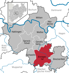
Ennepetal
- town in the district of Ennepe-Ruhr-Kreis, North Rhine-Westphalia, Germany
Hiking in Ennepetal
Ennepetal, located in North Rhine-Westphalia, Germany, offers a variety of hiking opportunities that cater to different levels of experience. The region is characterized by its picturesque landscapes, including forests, hills, and the beautiful valleys of the Ennepe River....
- Country:
- Postal Code: 58256
- Local Dialing Code: 02333; 0202
- Licence Plate Code: EN
- Coordinates: 51° 17' 0" N, 7° 20' 0" E
- GPS tracks (wikiloc): [Link]
- AboveSeaLevel: 200 м m
- Area: 57.42 sq km
- Population: 29929
- Web site: [Link]
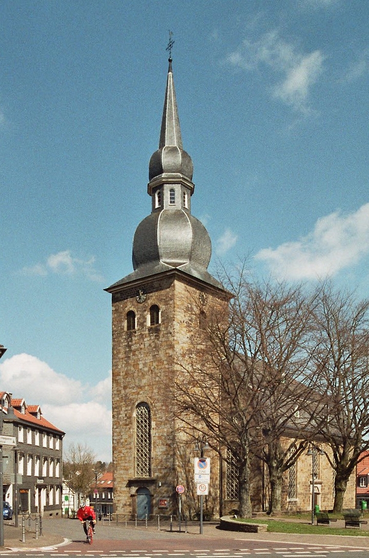
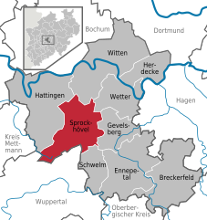
Sprockhövel
- town in Ennepe-Ruhr-Kreis, North Rhine-Westphalia, Germany
Hiking in Sprockhövel
Sprockhövel is a charming town located in North Rhine-Westphalia, Germany, and is surrounded by beautiful landscapes that are ideal for hiking enthusiasts. Here are some highlights and tips for hiking in the Sprockhövel area:...
- Country:
- Postal Code: 45549
- Local Dialing Code: 0202; 02324; 02339
- Licence Plate Code: EN, WIT
- Coordinates: 51° 21' 0" N, 7° 15' 0" E
- GPS tracks (wikiloc): [Link]
- AboveSeaLevel: 219 м m
- Area: 48 sq km
- Population: 24783
- Web site: [Link]
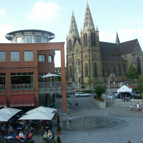

Solingen
- city in North Rhine-Westphalia of Germany
Hiking in Solingen
Solingen, a city located in North Rhine-Westphalia, Germany, is not only famous for its blades and cutlery but also offers a variety of hiking opportunities amidst beautiful landscapes. The region around Solingen is characterized by lush forests, rolling hills, and scenic views, making it an excellent destination for hikers of all levels....
- Country:
- Postal Code: 42601–42719
- Local Dialing Code: 0212
- Licence Plate Code: SG
- Coordinates: 51° 10' 0" N, 7° 5' 0" E
- GPS tracks (wikiloc): [Link]
- AboveSeaLevel: 53 м m
- Area: 89.54 sq km
- Population: 158908
- Web site: [Link]


Remscheid
- German city
Hiking in Remscheid
Remscheid, located in North Rhine-Westphalia, Germany, is an excellent destination for hiking enthusiasts. The region features beautiful landscapes, with a mix of forests, rivers, and hills, making it an ideal place for various hiking experiences. Here are some highlights and suggestions for hiking in and around Remscheid:...
- Country:
- Postal Code: 42853
- Local Dialing Code: 02191
- Licence Plate Code: RS
- Coordinates: 51° 11' 0" N, 7° 12' 0" E
- GPS tracks (wikiloc): [Link]
- AboveSeaLevel: 365 м m
- Area: 74.52 sq km
- Population: 110611
- Web site: [Link]


Hattingen
- town in the district of Ennepe-Ruhr-Kreis, in North Rhine-Westphalia, Germany
Hiking in Hattingen
Hattingen, located in North Rhine-Westphalia, Germany, is an excellent destination for hiking enthusiasts. This picturesque town, known for its medieval architecture and beautiful natural landscapes, offers a variety of trails that cater to different skill levels. Here are some highlights of hiking in Hattingen:...
- Country:
- Postal Code: 45529; 45527; 45525
- Local Dialing Code: 02324
- Licence Plate Code: EN, WIT
- Coordinates: 51° 23' 57" N, 7° 11' 9" E
- GPS tracks (wikiloc): [Link]
- AboveSeaLevel: 90 м m
- Area: 71.39 sq km
- Population: 54628
- Web site: [Link]


Mettmann
- district in North Rhine-Westphalia, Germany
Hiking in Mettmann
Mettmann, located in North Rhine-Westphalia, Germany, offers a variety of hiking opportunities that cater to different skill levels and preferences. The region features picturesque landscapes, including forests, hills, and scenic views, making it ideal for outdoor activities....
- Country:
- Licence Plate Code: ME
- Coordinates: 51° 15' 0" N, 7° 0' 0" E
- GPS tracks (wikiloc): [Link]
- AboveSeaLevel: 143 м m
- Web site: [Link]