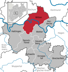
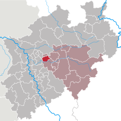
Ennepe-Ruhr-Kreis (Ennepe-Ruhr-Kreis)


- district in North Rhine-Westphalia, Germany
 Hiking in Ennepe-Ruhr-Kreis
Ennepe-Ruhr-Kreis, located in North Rhine-Westphalia, Germany, is an excellent destination for hiking enthusiasts. The region is characterized by its diverse landscapes, which include forests, hills, and scenic views of the Ruhr area. Here are some key points to consider when hiking in this region:
Trails and Routes
-
Sauerland Trails: The Ennepe-Ruhr-Kreis is part of the Sauerland region, which offers a network of marked trails. Popular long-distance trails include the Rothaarsteig and the Sauerland Höhenweg, both of which allow you to experience the natural beauty of the area.
-
Local Hiking Networks: There are several local hiking networks, such as the "Wanderbares Deutschland" initiative, which focuses on quality hiking trails that are well-marked and maintained.
-
Circular Routes: Many circular hiking routes exist, such as those around the cities of Witten, Gevelsberg, and Ennepetal. These are perfect for day hikes, allowing you to explore the countryside and return to your starting point.
Nature and Scenery
- Forests and Parks: The region is rich in forests, especially the beautiful Bochumer Wald and the Ennepetaler Talsystem. These areas provide shaded trails and opportunities for wildlife spotting.
- Rivers and Reservoirs: The Ennepe and other rivers create picturesque settings for hikes, with several trails that follow along waterways, giving hikers a chance to enjoy the sound of flowing water and scenic vistas.
- Hills and Lookouts: Don’t miss the elevated points that offer stunning views of the surrounding landscape, such as the lookout towers at places like the Hardt or the Voerder Höhe.
Best Times to Hike
- Spring and Fall: These seasons are particularly pleasant for hiking due to the mild weather, blooming nature in spring, and the beautiful autumn foliage.
- Summer: While summer can be hot, the forested areas provide plenty of shade, making it comfortable for hiking.
Practical Tips
- Maps and Guides: Ensure to carry a map or download a hiking app with the local trails to navigate effectively.
- Preparation: Wear appropriate footwear, and bring enough water and snacks to keep you energized.
- Local Regulations: Respect nature and follow local guidelines to preserve the environment.
Accessibility
The region is well-connected via public transportation, making it easy to access various hiking starting points without needing a car.
Overall, hiking in Ennepe-Ruhr-Kreis offers a mix of natural beauty, well-marked trails, and a range of difficulty levels, making it suitable for everyone from beginners to experienced hikers. Enjoy your adventure in this beautiful part of Germany!
- Country:

- Capital: Schwelm
- Licence Plate Code: WIT; EN
- Coordinates: 51° 21' 5" N, 7° 18' 26" E


- GPS tracks (wikiloc): [Link]
- AboveSeaLevel: 226 м m
- Area: 408.44 sq km
- Population: 322731
- Web site: https://www.enkreis.de/
- Wikipedia en: wiki(en)
- Wikipedia: wiki(de)
- Wikidata storage: Wikidata: Q11280
- Wikipedia Commons Gallery: [Link]
- Wikipedia Commons Category: [Link]
- Wikipedia Commons Maps Category: [Link]
- Freebase ID: [/m/0192jk]
- GeoNames ID: Alt: [2930044]
- VIAF ID: Alt: [312871812]
- OSM relation ID: [1829066]
- GND ID: Alt: [4014819-1]
- archINFORM location ID: [11052]
- Library of Congress authority ID: Alt: [no2009056150]
- TGN ID: [7189896]
- ISNI: Alt: [0000 0004 0565 429X]
- NUTS code: [DEA56]
- Ringgold ID: [40182]
- FAST ID: [1879144]
- GNS Unique Feature ID: -1766620
- German district key: 05954
Includes regions:


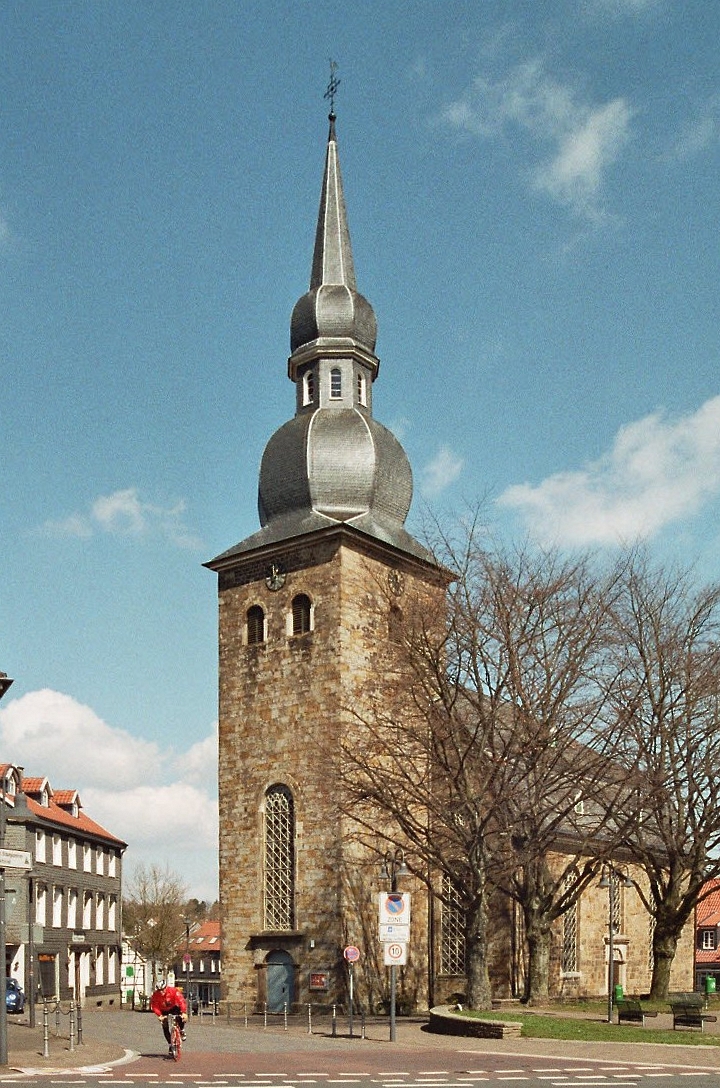
Schwelm
- seat of Ennepe-Ruhr-Kreis and town in North Rhine-Westphalia, Germany
Hiking in Schwelm
Schwelm, located in North Rhine-Westphalia, Germany, is a charming town that offers access to beautiful hiking trails, primarily within the surrounding mountainous regions and forests. The landscape in and around Schwelm is characterized by rolling hills, dense woodlands, and scenic views, making it a great area for outdoor enthusiasts....
- Country:
- Postal Code: 58332
- Local Dialing Code: 02336
- Licence Plate Code: EN
- Coordinates: 51° 16' 0" N, 7° 16' 0" E
- GPS tracks (wikiloc): [Link]
- AboveSeaLevel: 213 м m
- Area: 20.5 sq km
- Population: 28478
- Web site: [Link]

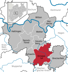
Ennepetal
- town in the district of Ennepe-Ruhr-Kreis, North Rhine-Westphalia, Germany
Hiking in Ennepetal
Ennepetal, located in North Rhine-Westphalia, Germany, offers a variety of hiking opportunities that cater to different levels of experience. The region is characterized by its picturesque landscapes, including forests, hills, and the beautiful valleys of the Ennepe River....
- Country:
- Postal Code: 58256
- Local Dialing Code: 02333; 0202
- Licence Plate Code: EN
- Coordinates: 51° 17' 0" N, 7° 20' 0" E
- GPS tracks (wikiloc): [Link]
- AboveSeaLevel: 200 м m
- Area: 57.42 sq km
- Population: 29929
- Web site: [Link]


Breckerfeld
- town in Ennepe-Ruhr-Kreis, North Rhine-Westphalia, Germany
Hiking in Breckerfeld
Breckerfeld, a small town located in North Rhine-Westphalia, Germany, is known for its picturesque landscapes and access to beautiful hiking trails....
- Country:
- Postal Code: 58339
- Local Dialing Code: 02337; 02195; 02331; 02333; 02338
- Licence Plate Code: EN
- Coordinates: 51° 16' 0" N, 7° 28' 0" E
- GPS tracks (wikiloc): [Link]
- AboveSeaLevel: 375 м m
- Area: 59 sq km
- Population: 8913
- Web site: [Link]

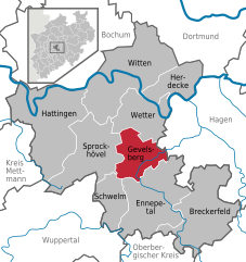
Gevelsberg
- town in Ennepe-Ruhr-Kreis, North Rhine-Westphalia, Germany
Hiking in Gevelsberg
Gevelsberg, a charming town located in North Rhine-Westphalia, Germany, offers several opportunities for hiking enthusiasts to explore its picturesque landscapes. Nestled in the Ruhr area, Gevelsberg is surrounded by beautiful natural settings, including rolling hills, forests, and scenic valleys....
- Country:
- Postal Code: 58285
- Local Dialing Code: 02332
- Licence Plate Code: EN
- Coordinates: 51° 18' 0" N, 7° 20' 0" E
- GPS tracks (wikiloc): [Link]
- AboveSeaLevel: 170 м m
- Area: 26.27 sq km
- Population: 30910
- Web site: [Link]


Herdecke
- town in Ennepe-Ruhr-Kreis, North Rhine-Westphalia, Germany
Hiking in Herdecke
Herdecke is a charming town located in North Rhine-Westphalia, Germany, situated near the Ruhr River and surrounded by picturesque landscapes, making it a great destination for hiking enthusiasts. The region is characterized by rolling hills, forests, and scenic views, providing a variety of trails for different skill levels....
- Country:
- Postal Code: 58313
- Local Dialing Code: 02330
- Licence Plate Code: EN
- Coordinates: 51° 24' 0" N, 7° 26' 0" E
- GPS tracks (wikiloc): [Link]
- AboveSeaLevel: 150 м m
- Area: 22.4 sq km
- Population: 22836
- Web site: [Link]
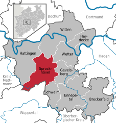
Sprockhövel
- town in Ennepe-Ruhr-Kreis, North Rhine-Westphalia, Germany
Hiking in Sprockhövel
Sprockhövel is a charming town located in North Rhine-Westphalia, Germany, and is surrounded by beautiful landscapes that are ideal for hiking enthusiasts. Here are some highlights and tips for hiking in the Sprockhövel area:...
- Country:
- Postal Code: 45549
- Local Dialing Code: 0202; 02324; 02339
- Licence Plate Code: EN, WIT
- Coordinates: 51° 21' 0" N, 7° 15' 0" E
- GPS tracks (wikiloc): [Link]
- AboveSeaLevel: 219 м m
- Area: 48 sq km
- Population: 24783
- Web site: [Link]


Wetter (Ruhr)
- town in the district of Ennepe-Ruhr-Kreis, in North Rhine-Westphalia, Germany
Hiking in Wetter (Ruhr)
Wetter (Ruhr) is a charming municipality located in the North Rhine-Westphalia region of Germany, offering a variety of outdoor recreation opportunities, including hiking. Nestled in the Ruhr area, it features scenic landscapes that appeal to outdoor enthusiasts. Here are some key points about hiking in Wetter (Ruhr):...
- Country:
- Postal Code: 58300
- Local Dialing Code: 02335
- Licence Plate Code: EN
- Coordinates: 51° 23' 17" N, 7° 23' 42" E
- GPS tracks (wikiloc): [Link]
- AboveSeaLevel: 110 м m
- Area: 31.47 sq km
- Population: 27628
- Web site: [Link]

Witten
- town in the district of Ennepe-Ruhr-Kreis, in North Rhine-Westphalia, Germany
Hiking in Witten
Witten, located in North Rhine-Westphalia, Germany, offers a variety of hiking opportunities that showcase the region's natural beauty and historical sites. Here are some highlights for hiking in and around Witten:...
- Country:
- Postal Code: 58456; 58455; 58454; 58453; 58452
- Local Dialing Code: 02302
- Coordinates: 51° 26' 0" N, 7° 20' 0" E
- GPS tracks (wikiloc): [Link]
- AboveSeaLevel: 104 м m
- Area: 72.37 sq km
- Population: 96565
- Web site: [Link]


Hattingen
- town in the district of Ennepe-Ruhr-Kreis, in North Rhine-Westphalia, Germany
Hiking in Hattingen
Hattingen, located in North Rhine-Westphalia, Germany, is an excellent destination for hiking enthusiasts. This picturesque town, known for its medieval architecture and beautiful natural landscapes, offers a variety of trails that cater to different skill levels. Here are some highlights of hiking in Hattingen:...
- Country:
- Postal Code: 45529; 45527; 45525
- Local Dialing Code: 02324
- Licence Plate Code: EN, WIT
- Coordinates: 51° 23' 57" N, 7° 11' 9" E
- GPS tracks (wikiloc): [Link]
- AboveSeaLevel: 90 м m
- Area: 71.39 sq km
- Population: 54628
- Web site: [Link]
Shares border with regions:


Dortmund
- town in North Rhine-Westphalia, Germany
Hiking in Dortmund
Dortmund, located in the North Rhine-Westphalia region of Germany, is not only known for its industrial heritage but also offers various opportunities for hiking and enjoying nature. Here are some highlights and tips for hiking in Dortmund:...
- Country:
- Postal Code: 44135–44388
- Local Dialing Code: 02304; 0231
- Licence Plate Code: DO
- Coordinates: 51° 30' 50" N, 7° 27' 55" E
- GPS tracks (wikiloc): [Link]
- AboveSeaLevel: 86 м m
- Area: 280.71 sq km
- Population: 585813
- Web site: [Link]


Essen
- city in North Rhine-Westphalia, Germany
Hiking in Essen
Essen, located in the Ruhr area of Germany, is surrounded by a mix of industrial heritage and natural landscapes, offering some unique hiking opportunities. While it's a city that has undergone significant transformations, nature enthusiasts can find various trails and parks that provide a nice escape from urban life. Here are some highlights for hiking in and around Essen:...
- Country:
- Postal Code: 45001; 45359
- Local Dialing Code: 02054; 0201
- Licence Plate Code: E
- Coordinates: 51° 27' 3" N, 7° 0' 47" E
- GPS tracks (wikiloc): [Link]
- AboveSeaLevel: 116 м m
- Area: 210.34 sq km
- Population: 590194
- Web site: [Link]

Bochum
- city in North Rhine-Westphalia, Germany
Hiking in Bochum
Bochum, located in the North Rhine-Westphalia region of Germany, is not traditionally known as a hiking destination, but it offers some interesting opportunities for outdoor enthusiasts. Here are a few highlights for hiking in and around Bochum:...
- Country:
- Postal Code: 44701–44894
- Local Dialing Code: 02327; 0234
- Licence Plate Code: BO
- Coordinates: 51° 29' 0" N, 7° 13' 0" E
- GPS tracks (wikiloc): [Link]
- AboveSeaLevel: 100 м m
- Area: 145.66 sq km
- Population: 364920
- Web site: [Link]


Wuppertal
- city in North Rhine-Westphalia, Germany
Hiking in Wuppertal
Wuppertal, located in North Rhine-Westphalia, Germany, offers some unique hiking opportunities, particularly due to its hilly landscape and green spaces. While Wuppertal is more famous for its iconic suspension railway, it also has beautiful trails that cater to different skill levels....
- Country:
- Postal Code: 42001–42399
- Local Dialing Code: 02053; 02058; 0202
- Licence Plate Code: W
- Coordinates: 51° 15' 38" N, 7° 10' 22" E
- GPS tracks (wikiloc): [Link]
- AboveSeaLevel: 157 м m
- Area: 168.39 sq km
- Population: 352390
- Web site: [Link]

Hagen
- German city in North Rhine-Westphalia
Hiking in Hagen
Hagen, located in North Rhine-Westphalia, Germany, offers a variety of hiking opportunities that showcase the area's natural beauty and diverse landscapes. Here are some highlights and tips for hiking in and around Hagen:...
- Country:
- Postal Code: 58000–58135
- Local Dialing Code: 02331; 02304; 02337; 02334
- Licence Plate Code: HA
- Coordinates: 51° 21' 34" N, 7° 28' 30" E
- GPS tracks (wikiloc): [Link]
- AboveSeaLevel: 106 м m
- Area: 160.45 sq km
- Population: 188266
- Web site: [Link]
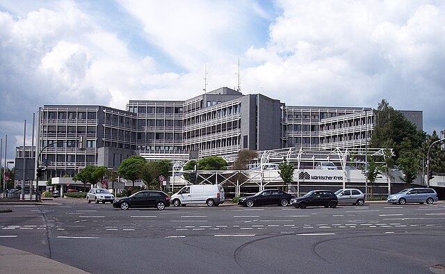

Märkischer Kreis
- district in central North Rhine-Westphalia, Germany
Hiking in Märkischer Kreis
Märkischer Kreis, located in North Rhine-Westphalia, Germany, is a beautiful region for hiking enthusiasts. It offers a blend of natural landscapes, charming small towns, and cultural heritage. Here are some highlights and things to know about hiking in this area:...
- Country:
- Capital: Lüdenscheid
- Licence Plate Code: MK
- Coordinates: 51° 13' 30" N, 7° 36' 52" E
- GPS tracks (wikiloc): [Link]
- AboveSeaLevel: 186 м m
- Area: 1058.95 sq km
- Population: 416171
- Web site: [Link]


Mettmann
- district in North Rhine-Westphalia, Germany
Hiking in Mettmann
Mettmann, located in North Rhine-Westphalia, Germany, offers a variety of hiking opportunities that cater to different skill levels and preferences. The region features picturesque landscapes, including forests, hills, and scenic views, making it ideal for outdoor activities....
- Country:
- Licence Plate Code: ME
- Coordinates: 51° 15' 0" N, 7° 0' 0" E
- GPS tracks (wikiloc): [Link]
- AboveSeaLevel: 143 м m
- Web site: [Link]

Oberbergischer Kreis
- district of North Rhine-Westphalia, Germany
Hiking in Oberbergischer Kreis
Oberbergischer Kreis, located in North Rhine-Westphalia, Germany, is known for its beautiful landscapes, rolling hills, and dense forests, making it a fantastic destination for hiking enthusiasts. Here are some key details to help you plan your hiking adventure in this region:...
- Country:
- Licence Plate Code: GM
- Coordinates: 51° 2' 0" N, 7° 31' 0" E
- GPS tracks (wikiloc): [Link]
- AboveSeaLevel: 413 м m
- Area: 918.53 sq km
- Population: 271332
- Web site: [Link]