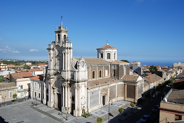
Zafferana Etnea (Zafferana Etnea)
.svg)
- Italian comune
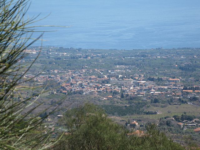
 Hiking in Zafferana Etnea
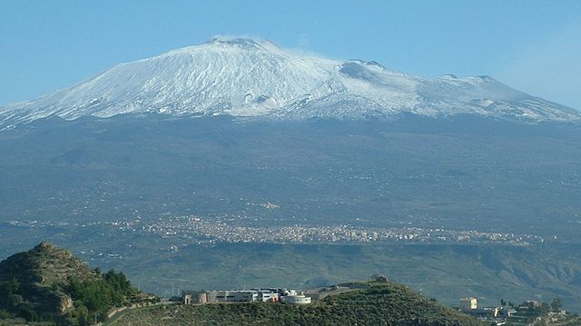
Zafferana Etnea, located on the eastern slope of Mount Etna in Sicily, Italy, is a beautiful destination for hiking enthusiasts. The region is renowned for its stunning landscapes, rich biodiversity, and unique volcanic terrain. Here are some highlights and tips for hiking in Zafferana Etnea:
Trails and Routes
-
Monti Silvestri: This area features several trails that offer incredible views of Mount Etna and the surrounding landscape. The terrain includes lava fields, pine forests, and craters formed by past eruptions.
-
Etna Park: Zafferana Etnea serves as an excellent gateway to the Parco dell'Etna (Etna Park), which offers numerous hiking paths suitable for all skill levels. Many trails are well-maintained and marked, leading through picturesque landscapes, vineyards, and traditional Sicilian villages.
-
Piano Provenzana: This is a popular starting point for hikes on the northern side of Etna, where you can explore the craters and witness diverse flora and fauna.
-
Sentiero dei Vulcani: This is a scenic route that takes you to various volcanic features in the area, combining natural beauty with educational insights about volcanology.
What to Expect
- Volcanic Landscapes: The diverse geological formations are fascinating, and you'll encounter various textures, from smooth lava flows to rugged craters.
- Flora and Fauna: The region is home to unique plant species and wildlife. Look out for endemic species adapted to the volcanic environment.
- Cultural Sites: Besides natural beauty, you can discover charming villages, ancient churches, and local wineries along some hiking routes.
Practical Tips
- Weather: The weather can vary significantly, especially as you ascend Mount Etna. Be prepared for rapid changes and check forecasts before you head out.
- Gear: Wear sturdy hiking boots, carry enough water, and bring snacks. A walking stick might also be helpful on hilly or uneven terrain.
- Guided Tours: If you're unsure about navigating the area, consider joining a guided hiking tour. Local guides can provide insights and ensure your safety on the trails.
- Respect Nature: Stay on marked trails to protect the delicate ecosystem, and follow Leave No Trace principles.
Conclusion
Hiking in Zafferana Etnea offers an exciting blend of adventure, natural beauty, and cultural experiences. Whether you're hiking along the volcanic craters or enjoying the views from the mountains, this region has something for everyone. Always prioritize safety and be prepared for the unique conditions of hiking in a volcanic area. Happy hiking!
- Country:

- Postal Code: 95019
- Local Dialing Code: 095
- Licence Plate Code: CT
- Coordinates: 37° 41' 0" N, 15° 6' 0" E


- GPS tracks (wikiloc): [Link]
- AboveSeaLevel: 574 м m
- Area: 76.87 sq km
- Population: 9607
- Web site: http://www.comune.zafferana-etnea.ct.it/
- Wikipedia en: wiki(en)
- Wikipedia: wiki(it)
- Wikidata storage: Wikidata: Q140202
- Wikipedia Commons Gallery: [Link]
- Wikipedia Commons Category: [Link]
- Freebase ID: [/m/0gqhv_]
- GeoNames ID: Alt: [6539205]
- VIAF ID: Alt: [158380429]
- OSM relation ID: [39321]
- GND ID: Alt: [4294098-9]
- MusicBrainz area ID: [5a66cdba-9c43-4627-ab08-1fd8a87808fc]
- UN/LOCODE: [ITZZF]
- ISTAT ID: 087055
- Italian cadastre code: M139
Shares border with regions:

Acireale
- Italian comune
Hiking in Acireale
Acireale, located in Sicily, Italy, is not only famous for its beautiful Baroque architecture but also offers stunning opportunities for hiking and exploring the natural beauty of the region. Here are some highlights and tips for hiking in and around Acireale:...
- Country:
- Postal Code: 95024
- Local Dialing Code: 095
- Licence Plate Code: CT
- Coordinates: 37° 36' 45" N, 15° 9' 56" E
- GPS tracks (wikiloc): [Link]
- AboveSeaLevel: 102 м m
- Area: 40.43 sq km
- Population: 52574
- Web site: [Link]
Aci Sant'Antonio
- Italian comune
Hiking in Aci Sant'Antonio
Aci Sant'Antonio is a charming town located in Sicily, Italy, near the eastern coast and not far from Mount Etna. Although it may not be as widely recognized as some other hiking destinations, the surrounding areas offer a variety of trails and natural beauty that can be explored. Here are some insights into hiking in and around Aci Sant'Antonio:...
- Country:
- Postal Code: 95025
- Local Dialing Code: 095
- Licence Plate Code: CT
- Coordinates: 37° 36' 0" N, 15° 7' 0" E
- GPS tracks (wikiloc): [Link]
- AboveSeaLevel: 302 м m
- Area: 14.33 sq km
- Population: 18076
- Web site: [Link]
Adrano
- Italian comune
Hiking in Adrano
Adrano is a charming town located in Sicily, Italy, and is surrounded by the beautiful landscapes of Mount Etna and the Sicilian countryside. Hiking in and around Adrano offers a mix of natural beauty, historical sites, and diverse trails suitable for all skill levels....
- Country:
- Postal Code: 95031
- Local Dialing Code: 095
- Licence Plate Code: CT
- Coordinates: 37° 39' 45" N, 14° 50' 8" E
- GPS tracks (wikiloc): [Link]
- AboveSeaLevel: 560 м m
- Area: 83.22 sq km
- Population: 35633
- Web site: [Link]
Belpasso
- Italian comune
Hiking in Belpasso
Belpasso, located on the eastern slope of Mount Etna in Sicily, Italy, offers a variety of hiking opportunities that combine stunning natural landscapes, fascinating geological features, and rich local history. Here are some key aspects to consider for a hiking experience in Belpasso:...
- Country:
- Postal Code: 95032
- Local Dialing Code: 095
- Licence Plate Code: CT
- Coordinates: 37° 35' 0" N, 14° 59' 0" E
- GPS tracks (wikiloc): [Link]
- AboveSeaLevel: 551 м m
- Area: 166.33 sq km
- Population: 28126
- Web site: [Link]

Biancavilla
- Italian comune
Hiking in Biancavilla
Biancavilla is a charming town located in the Sicilian region of Italy, nestled on the slopes of Mount Etna, Europe's highest and most active volcano. The surrounding area offers a diverse range of hiking opportunities suitable for various skill levels, with stunning landscapes, rich biodiversity, and unique geological features. Here’s an overview of what you can expect when hiking in Biancavilla:...
- Country:
- Postal Code: 95033
- Local Dialing Code: 095
- Licence Plate Code: CT
- Coordinates: 37° 38' 43" N, 14° 51' 49" E
- GPS tracks (wikiloc): [Link]
- AboveSeaLevel: 513 м m
- Area: 70.28 sq km
- Population: 23948
- Web site: [Link]
Bronte, Sicily
- Italian comune
Hiking in Bronte, Sicily
Bronte, a charming town located in Sicily, Italy, is surrounded by stunning landscapes that are perfect for hiking enthusiasts. Known for its pistachio production, Bronte is situated on the slopes of Mount Etna, one of the most active volcanoes in the world, which offers numerous trails and opportunities for exploration....
- Country:
- Postal Code: 95034
- Local Dialing Code: 095
- Licence Plate Code: CT
- Coordinates: 37° 48' 0" N, 14° 50' 0" E
- GPS tracks (wikiloc): [Link]
- AboveSeaLevel: 760 м m
- Area: 250.86 sq km
- Population: 18963
- Web site: [Link]

Castiglione di Sicilia
- Italian comune
Hiking in Castiglione di Sicilia
Castiglione di Sicilia, located in the Etna region of Sicily, is a delightful destination for hiking enthusiasts. Situated on a hillside overlooking the Alcantara River, this charming medieval town offers breathtaking views and access to a variety of trails that cater to different skill levels. Here are some highlights of hiking in and around Castiglione di Sicilia:...
- Country:
- Postal Code: 95012
- Local Dialing Code: 0942
- Licence Plate Code: CT
- Coordinates: 37° 52' 58" N, 15° 7' 21" E
- GPS tracks (wikiloc): [Link]
- AboveSeaLevel: 621 м m
- Area: 118.9 sq km
- Population: 3129
- Web site: [Link]
Giarre
- Italian comune
Hiking in Giarre
Giarre, located on the eastern coast of Sicily, Italy, is a charming town that serves as a gateway to various hiking opportunities in the region. Nestled between Mount Etna and the beautiful coastline, Giarre offers stunning landscapes, diverse flora and fauna, and various trails suitable for different skill levels....
- Country:
- Postal Code: 95014
- Local Dialing Code: 095
- Licence Plate Code: CT
- Coordinates: 37° 43' 47" N, 15° 11' 4" E
- GPS tracks (wikiloc): [Link]
- AboveSeaLevel: 81 м m
- Area: 27.32 sq km
- Population: 27546
- Web site: [Link]

Maletto
- Italian comune
Hiking in Maletto
Maletto is a charming town located in the province of Catania in Sicily, Italy. Its position in the Nebrodi National Park makes it a wonderful destination for hiking enthusiasts. Here are some highlights about hiking in and around Maletto:...
- Country:
- Postal Code: 95035
- Local Dialing Code: 095
- Licence Plate Code: CT
- Coordinates: 37° 50' 0" N, 14° 52' 0" E
- GPS tracks (wikiloc): [Link]
- AboveSeaLevel: 960 м m
- Area: 40.96 sq km
- Population: 3818
- Web site: [Link]

Milo, Sicily
- Italian comune
Hiking in Milo, Sicily
Hiking in Milo, Catania, offers a unique experience due to its stunning landscapes, rich flora and fauna, and proximity to Mount Etna, Europe’s highest and most active volcano. Here are some highlights and tips for hiking in this beautiful area:...
- Country:
- Postal Code: 95010
- Local Dialing Code: 095
- Licence Plate Code: CT
- Coordinates: 37° 43' 0" N, 15° 7' 0" E
- GPS tracks (wikiloc): [Link]
- AboveSeaLevel: 720 м m
- Area: 16.67 sq km
- Population: 1049
- Web site: [Link]

Nicolosi
- Italian comune
Hiking in Nicolosi
Nicolosi, located on the eastern slopes of Mount Etna in Sicily, Italy, is a fantastic destination for hiking enthusiasts. The area offers a variety of trails set against a stunning backdrop of volcanic landscapes, lush forests, and panoramic views of the surrounding region....
- Country:
- Postal Code: 95030
- Local Dialing Code: 095
- Licence Plate Code: CT
- Coordinates: 37° 37' 0" N, 15° 1' 0" E
- GPS tracks (wikiloc): [Link]
- AboveSeaLevel: 700 м m
- Area: 42.65 sq km
- Population: 7528
- Web site: [Link]
Pedara
- Italian comune
Hiking in Pedara
Pedara, a charming town located on the slopes of Mount Etna in Sicily, Italy, offers a variety of hiking opportunities that attract outdoor enthusiasts and nature lovers. Here are some highlights and tips for hiking in and around Pedara:...
- Country:
- Postal Code: 95030
- Local Dialing Code: 095
- Licence Plate Code: CT
- Coordinates: 37° 37' 26" N, 15° 3' 24" E
- GPS tracks (wikiloc): [Link]
- AboveSeaLevel: 610 м m
- Area: 19.23 sq km
- Population: 14613
- Web site: [Link]

Randazzo
- Italian comune
Hiking in Randazzo
Randazzo is a charming town located in Sicily, Italy, nestled at the foot of Mount Etna. It offers a variety of hiking opportunities that cater to different skill levels, allowing hikers to explore beautiful landscapes, historical sites, and the stunning natural scenery of the region....
- Country:
- Postal Code: 95036
- Local Dialing Code: 095
- Licence Plate Code: CT
- Coordinates: 37° 53' 0" N, 14° 57' 0" E
- GPS tracks (wikiloc): [Link]
- AboveSeaLevel: 765 м m
- Area: 205.62 sq km
- Population: 10763
- Web site: [Link]
Sant'Alfio
- Italian comune
Hiking in Sant'Alfio
Sant'Alfio is a charming town located on the eastern side of Sicily, Italy, known for its beautiful landscapes, rich history, and proximity to Mount Etna. When it comes to hiking in Sant'Alfio, there are several options that allow you to explore the stunning natural surroundings....
- Country:
- Postal Code: 95010
- Local Dialing Code: 095
- Licence Plate Code: CT
- Coordinates: 37° 45' 0" N, 15° 8' 0" E
- GPS tracks (wikiloc): [Link]
- AboveSeaLevel: 531 м m
- Area: 25.86 sq km
- Population: 1563
- Web site: [Link]
Santa Venerina
- Italian comune
Hiking in Santa Venerina
Santa Venerina, located on the eastern slopes of Mount Etna in Sicily, Italy, offers some stunning hiking opportunities for outdoor enthusiasts. The area is characterized by its volcanic landscapes, lush greenery, and views of the coast and the surrounding mountains....
- Country:
- Postal Code: 95010
- Local Dialing Code: 095
- Licence Plate Code: CT
- Coordinates: 37° 41' 0" N, 15° 8' 0" E
- GPS tracks (wikiloc): [Link]
- AboveSeaLevel: 337 м m
- Area: 19.03 sq km
- Population: 8553
- Web site: [Link]

Trecastagni
- Italian comune
Hiking in Trecastagni
Trecastagni is a charming town located on the eastern slopes of Mount Etna in Sicily, Italy. It is an excellent base for hiking enthusiasts looking to explore the stunning landscapes of the region, particularly those related to the majestic active volcano, Mount Etna, which is known for its diverse ecosystems, unique geological features, and breathtaking views....
- Country:
- Postal Code: 95039
- Local Dialing Code: 095
- Licence Plate Code: CT
- Coordinates: 37° 37' 0" N, 15° 5' 0" E
- GPS tracks (wikiloc): [Link]
- AboveSeaLevel: 586 м m
- Area: 19.16 sq km
- Population: 11074
- Web site: [Link]
Viagrande
- Italian comune
Hiking in Viagrande
Viagrande, located in the eastern part of Sicily, Italy, offers a beautiful hiking experience characterized by its scenic landscapes, lush vegetation, and views of Mount Etna. Here’s what you need to know about hiking in Viagrande:...
- Country:
- Postal Code: 95029
- Local Dialing Code: 095
- Licence Plate Code: CT
- Coordinates: 37° 37' 0" N, 15° 6' 0" E
- GPS tracks (wikiloc): [Link]
- AboveSeaLevel: 410 м m
- Area: 10.09 sq km
- Population: 8677
- Web site: [Link]