Zagarolo (Zagarolo)
.svg)
- Italian comune
 Hiking in Zagarolo
Zagarolo, located in the Lazio region of Italy, is a charming town with beautiful landscapes ideal for hiking enthusiasts. The surrounding area is characterized by rolling hills, lush vegetation, and stunning views of the Roman countryside. Here are some highlights about hiking in Zagarolo:
Trails and Routes
-
Parco Naturale Regionale dei Castelli Romani: This nearby natural park offers a variety of trails that immerse you in a scenic environment filled with lakes, woodlands, and volcanic formations. While the park is more expansive than Zagarolo itself, it is easily accessible for day hikes.
-
Historical Trails: Zagarolo features routes that connect various historical sites, including ancient churches, castles, and ruins. Exploring these paths provides both exercise and cultural enrichment.
-
Via Francigena: The ancient pilgrimage route passes near Zagarolo and offers various hiking opportunities. You can enjoy this historic trail while taking in the stunning countryside and charming villages nearby.
Tips for Hiking in Zagarolo
- Local Guides: Consider hiring a local guide or joining a hiking group to explore hidden gems and learn about the area's history and ecology.
- Weather Preparedness: The weather can change quickly, so dress in layers and check forecasts before heading out.
- Hydration and Snacks: Carry enough water and snacks, especially on longer hikes, as amenities may be scarce along the trails.
- Respect Nature: Follow Leave No Trace principles—stay on marked trails, dispose of waste properly, and respect wildlife.
Recommended Hiking Seasons
The best times to hike in Zagarolo are during the spring (April to June) and fall (September to October) when the temperatures are mild, and the landscape is particularly beautiful with blooming flora or vibrant autumn leaves.
Local Attractions
After a hike, indulge in Zagarolo’s local cuisine, which includes traditional Italian dishes and homemade wines. Exploring the town itself can also be a rewarding experience, with its narrow streets and historical architecture.
Hiking in and around Zagarolo offers a wonderful blend of physical activity, natural beauty, and cultural exploration, making it a fantastic destination for outdoor enthusiasts.
- Country:

- Postal Code: 00039
- Local Dialing Code: 06
- Licence Plate Code: RM
- Coordinates: 41° 50' 0" N, 12° 50' 0" E


- GPS tracks (wikiloc): [Link]
- AboveSeaLevel: 303 м m
- Area: 28.04 sq km
- Population: 17933
- Web site: http://www.zagarolo.rm.gov.it
- Wikipedia en: wiki(en)
- Wikipedia: wiki(it)
- Wikidata storage: Wikidata: Q140255
- Wikipedia Commons Category: [Link]
- Freebase ID: [/m/0f5prz]
- GeoNames ID: Alt: [6541653]
- VIAF ID: Alt: [245120415]
- OSM relation ID: [41596]
- GND ID: Alt: [4299230-8]
- MusicBrainz area ID: [250e57eb-1ff0-46de-af87-ee7790db22d0]
- WOEID: [726359]
- UN/LOCODE: [ITRMZ]
- Digital Atlas of the Roman Empire ID: [24338]
- ISTAT ID: 058114
- Italian cadastre code: M141
Shares border with regions:
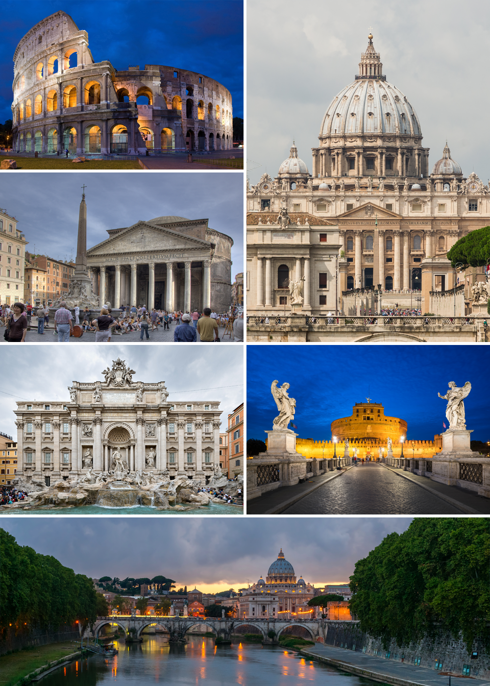

Rome
- capital and largest city of Italy
Hiking in Rome
Hiking in and around Rome offers a unique way to explore not just the historic city itself but also the beautiful landscapes and trails in the surrounding areas. While most visitors focus on the city’s famous landmarks, hiking provides a different perspective and a chance to escape the hustle and bustle. Here are some great options for hiking in Rome and its surroundings:...
- Country:
- Postal Code: 00118–00199
- Local Dialing Code: 06
- Licence Plate Code: RM
- Coordinates: 41° 53' 35" N, 12° 28' 58" E
- GPS tracks (wikiloc): [Link]
- AboveSeaLevel: 21 м m
- Area: 1287.36 sq km
- Population: 2873494
- Web site: [Link]


Colonna, Lazio
- Italian comune
Hiking in Colonna, Lazio
Hiking in Colonna, a town in the Lazio region of Italy, offers a blend of scenic trails and rich cultural history. Nestled in the hills near Rome, Colonna is surrounded by beautiful landscapes, vineyards, and olive groves, making it an appealing destination for outdoor enthusiasts....
- Country:
- Postal Code: 00030
- Local Dialing Code: 06
- Licence Plate Code: ROMA
- Coordinates: 41° 50' 0" N, 12° 45' 0" E
- GPS tracks (wikiloc): [Link]
- AboveSeaLevel: 393 м m
- Area: 3.55 sq km
- Population: 4312
- Web site: [Link]
Gallicano nel Lazio
- Italian comune
Hiking in Gallicano nel Lazio
Gallicano nel Lazio is a charming town located in the province of Rome, Italy. Nestled in the foothills of the Apennine Mountains, it offers various hiking opportunities that allow you to immerse yourself in the natural beauty of the region while enjoying the rich history and culture of the area....
- Country:
- Postal Code: 00010
- Local Dialing Code: 06
- Licence Plate Code: RM
- Coordinates: 41° 52' 0" N, 12° 49' 0" E
- GPS tracks (wikiloc): [Link]
- AboveSeaLevel: 241 м m
- Area: 25.7 sq km
- Population: 6343
- Web site: [Link]


Monte Compatri
- Italian comune
Hiking in Monte Compatri
Monte Compatri, located near Rome, Italy, offers some fantastic hiking opportunities, particularly within the scenic area of the Castelli Romani regional park. Here are some highlights and tips for hiking in this charming region:...
- Country:
- Postal Code: 00077
- Local Dialing Code: 06
- Licence Plate Code: ROMA
- Coordinates: 41° 48' 29" N, 12° 44' 14" E
- GPS tracks (wikiloc): [Link]
- AboveSeaLevel: 576 м m
- Area: 24.57 sq km
- Population: 12134
- Web site: [Link]


Palestrina
- Italian comune
Hiking in Palestrina
Palestrina, located just east of Rome, Italy, is not only rich in history but also offers various hiking opportunities that blend natural beauty with cultural exploration. Here are some aspects of hiking in Palestrina:...
- Country:
- Postal Code: 00036
- Local Dialing Code: 06
- Licence Plate Code: ROMA
- Coordinates: 41° 50' 0" N, 12° 54' 0" E
- GPS tracks (wikiloc): [Link]
- AboveSeaLevel: 450 м m
- Area: 47.02 sq km
- Population: 21872
- Web site: [Link]
San Cesareo
- Italian comune
Hiking in San Cesareo
San Cesareo, located in the Lazio region of Italy, offers scenic hiking opportunities amidst beautiful landscapes and historical sites. Here are some highlights and tips for hiking in this area:...
- Country:
- Postal Code: 00030
- Local Dialing Code: 06
- Licence Plate Code: ROMA
- Coordinates: 41° 49' 0" N, 12° 48' 0" E
- GPS tracks (wikiloc): [Link]
- AboveSeaLevel: 312 м m
- Area: 23.64 sq km
- Population: 15552
- Web site: [Link]