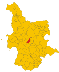
Zerfaliu (Zerfaliu)
- Italian comune
Zerfaliu is a lesser-known gem located in the region of Sardinia, Italy. It's an area that provides impressive landscapes, traditional culture, and the opportunity for varied hiking experiences. Here are some key points to consider if you're planning to hike in Zerfaliu:
Trails and Terrain
- Diverse Terrain: The region boasts a mix of mountainous areas, hills, and valleys, providing a range of hiking experiences, from gentle walks to more challenging trails.
- Natural Beauty: Expect stunning views of the surrounding countryside, including rocky formations, lush vegetation, and perhaps glimpses of local wildlife.
Difficulty Levels
- There are trails that cater to all skill levels, from easy, flat paths suitable for beginners and families to more demanding hikes that may require a higher level of fitness and experience.
Best Seasons to Hike
- Spring and Fall: These seasons are typically the best times for hiking in Zerfaliu due to milder weather and vibrant flora.
- Summer: Can be hot, so early morning or late afternoon hikes are advisable to avoid the heat of the day.
- Winter: Some trails might be accessible, but weather conditions can vary, and it's essential to check for snow or heavy rain.
Preparation and Safety
- Footwear and Gear: Invest in good quality hiking shoes, weather-appropriate clothing, and carry essential gear like water, snacks, and a first-aid kit.
- Navigation: While popular trails may be well-marked, having a detailed map or GPS device can be helpful, especially for less-traveled paths.
Local Culture
- Pay attention to the local culture and customs. Interacting with locals can enrich your experience.
- You might encounter traditional Sardinian farms or agriturismos, which can offer delicious local food and a glimpse into regional life.
Environmental Considerations
- Practice Leave No Trace principles to preserve the natural beauty of Zerfaliu and ensure that it remains pristine for future visitors.
Resources
- Before you go, check local websites or contact local hiking clubs for updated trail information, guided tours, and safety tips specific to Zerfaliu.
By exploring this enchanting area, you can enjoy both the physical challenge of hiking and the serene beauty of Sardinia’s countryside!
- Country:

- Postal Code: 09070
- Local Dialing Code: 0783
- Licence Plate Code: OR
- Coordinates: 39° 57' 36" N, 8° 42' 36" E


- GPS tracks (wikiloc): [Link]
- AboveSeaLevel: 15 м m
- Area: 15.56 sq km
- Population: 1075
- Web site: http://www.comune.zerfaliu.or.it
- Wikipedia en: wiki(en)
- Wikipedia: wiki(it)
- Wikidata storage: Wikidata: Q191629
- Wikipedia Commons Category: [Link]
- Freebase ID: [/m/0gr1fy]
- GeoNames ID: Alt: [6539383]
- OSM relation ID: [40163]
- ISTAT ID: 095075
- Italian cadastre code: M168
Shares border with regions:


Ollastra
- Italian comune
Ollastra is a small town located in the region of Sardinia, Italy, known for its beautiful landscapes and natural surroundings. Although it may not be as renowned as some other hiking destinations, the area offers various trails that are perfect for outdoor enthusiasts looking to enjoy the natural beauty of Sardinia....
- Country:

- Postal Code: 09084
- Local Dialing Code: 0783
- Licence Plate Code: OR
- Coordinates: 39° 57' 5" N, 8° 44' 5" E


- GPS tracks (wikiloc): [Link]
- AboveSeaLevel: 23 м m
- Area: 21.47 sq km
- Population: 1212
- Web site: [Link]


Paulilatino
- Italian comune
Paulilatino is a scenic area located in the province of Nuoro on the island of Sardinia, Italy. It's known for its stunning landscapes, rich history, and diverse wildlife, making it an excellent destination for hiking enthusiasts. Here are some key points to consider if you plan to hike in Paulilatino:...
- Country:

- Postal Code: 09070
- Local Dialing Code: 0785
- Licence Plate Code: OR
- Coordinates: 40° 5' 0" N, 8° 46' 0" E


- GPS tracks (wikiloc): [Link]
- AboveSeaLevel: 280 м m
- Area: 103.85 sq km
- Population: 2207
- Web site: [Link]


Simaxis
- Italian comune
Simaxis is a small town located in the province of Oristano on the island of Sardinia, Italy. While it may not be a mainstream hiking destination, the surrounding countryside and areas nearby offer opportunities for outdoor adventures....
- Country:

- Postal Code: 09088
- Local Dialing Code: 0783
- Licence Plate Code: OR
- Coordinates: 39° 43' 15" N, 8° 49' 41" E


- GPS tracks (wikiloc): [Link]
- AboveSeaLevel: 12 м m
- Area: 27.82 sq km
- Population: 2227
- Web site: [Link]


Solarussa
- Italian comune
Solarussa is a charming town located in the Oristano province of Sardinia, Italy. While it may not be as well-known for hiking as some other destinations, the surrounding natural landscapes offer a variety of opportunities for outdoor enthusiasts. Here are some insights about hiking in and around Solarussa:...
- Country:

- Postal Code: 09077
- Local Dialing Code: 0783
- Licence Plate Code: OR
- Coordinates: 39° 57' 16" N, 8° 40' 18" E


- GPS tracks (wikiloc): [Link]
- AboveSeaLevel: 20 м m
- Area: 31.86 sq km
- Population: 2400
- Web site: [Link]


Villanova Truschedu
- Italian comune
Villanova Truschedu is a charming village in the province of Oristano in Sardinia, Italy. Known for its stunning natural beauty and rich history, it's a great destination for hiking enthusiasts. Here are some insights into hiking in and around Villanova Truschedu:...
- Country:

- Postal Code: 09084
- Local Dialing Code: 0783
- Licence Plate Code: OR
- Coordinates: 39° 59' 18" N, 8° 45' 7" E


- GPS tracks (wikiloc): [Link]
- AboveSeaLevel: 56 м m
- Area: 16.61 sq km
- Population: 301
- Web site: [Link]

