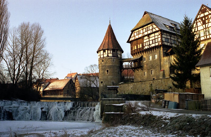
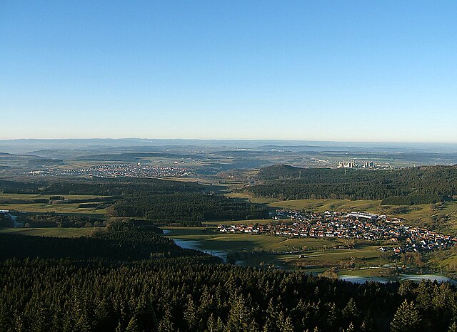
Zollernalb (Zollernalbkreis)

- district of Baden-Württemberg, Germany
 Hiking in Zollernalb
Zollernalbkreis, located in the state of Baden-Württemberg in Germany, offers a variety of hiking opportunities for outdoor enthusiasts. The region is characterized by its picturesque landscapes, rolling hills, dense forests, and charming villages. Here are some highlights and tips for hiking in Zollernalbkreis:
Trails and Areas
-
Swabian Jura (Schwäbische Alb): This stunning limestone plateau features numerous hiking trails with breathtaking views, unique rock formations, and diverse flora and fauna. Popular routes include the Albsteig, which connects several picturesque locations along the Swabian Jura.
-
Hiking Trails:
- Hohenzollern Castle: Hike to the majestic Hohenzollern Castle, which offers panoramic views of the surrounding countryside. The trail is well-marked and suitable for most hikers.
- Zollernalbweg: This long-distance trail stretches for about 140 kilometers (around 87 miles) and runs through the Zollernalbkreis, linking several towns and attractions. It offers a variety of landscapes, from forests to meadows.
-
Nature Reserves: Many areas in Zollernalbkreis are protected nature reserves, providing opportunities to see local wildlife and plants. Be respectful of the natural environment and stick to marked paths.
Tips for Hiking
- Trail Maps and Signage: Ensure you have a good map or GPS device, as some trails may not be clearly marked. Local tourist information centers can provide maps and additional resources.
- Weather Preparedness: Check the weather forecast before heading out, as conditions can change quickly in mountainous areas. Dress in layers and bring waterproof gear if necessary.
- Safety: Always inform someone about your hiking plans and expected return time. Carry a first aid kit, plenty of water, and snacks.
- Respect Nature: Follow the 'Leave No Trace' principles to minimize your impact on the environment. Stay on designated paths and dispose of waste properly.
Seasonal Considerations
- Spring and Summer: These seasons are ideal for hiking, as the weather is milder and the flora is in full bloom.
- Fall: Autumn offers stunning foliage and cooler temperatures, making for scenic hikes.
- Winter: Some trails may be suitable for winter hiking or snowshoeing, although conditions can vary, so check local guidance.
Hiking in Zollernalbkreis can be a rewarding experience, whether you are looking for a leisurely stroll or a challenging trek. Enjoy the beauty of the Swabian Jura and the rich history of the region!
- Country:

- Capital: Balingen
- Licence Plate Code: BL
- Coordinates: 48° 17' 0" N, 8° 56' 0" E


- GPS tracks (wikiloc): [Link]
- Population: 188170
- Web site: http://www.zollernalbkreis.de
- Wikipedia en: wiki(en)
- Wikipedia: wiki(de)
- Wikidata storage: Wikidata: Q8233
- Wikipedia Commons Category: [Link]
- Freebase ID: [/m/01lfjd]
- GeoNames ID: Alt: [3220794]
- VIAF ID: Alt: [131336814]
- OSM relation ID: [2797573]
- GND ID: Alt: [4067940-8]
- archINFORM location ID: [2678]
- Library of Congress authority ID: Alt: [n79074937]
- TGN ID: [7077324]
- NUTS code: [DE143]
- German district key: 08417
Includes regions:

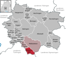
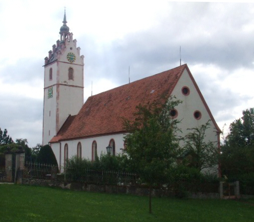
Nusplingen
- municipality in Germany
Hiking in Nusplingen
Nusplingen is a small village located in the Swabian Jura region of Germany, known for its picturesque landscape, rich natural beauty, and historic charm. Hiking in and around Nusplingen offers a variety of trails suitable for different skill levels, making it an excellent destination for both novice and experienced hikers....
- Country:
- Postal Code: 72362
- Local Dialing Code: 07429
- Licence Plate Code: BL
- Coordinates: 48° 8' 0" N, 8° 52' 0" E
- GPS tracks (wikiloc): [Link]
- AboveSeaLevel: 907 м m
- Area: 20.75 sq km
- Population: 1785
- Web site: [Link]


Rosenfeld
- city in Zollernalbkreis, Baden-Württemberg, Germany
Hiking in Rosenfeld
Rosenfeld, a charming town located in the Swabian region of Germany, offers beautiful landscapes and numerous trails perfect for hiking enthusiasts. The region is characterized by its picturesque hills, lush forests, and panoramic views of the surrounding countryside....
- Country:
- Postal Code: 72348
- Local Dialing Code: 07428
- Licence Plate Code: BL
- Coordinates: 48° 17' 11" N, 8° 43' 27" E
- GPS tracks (wikiloc): [Link]
- AboveSeaLevel: 620 м m
- Area: 51.11 sq km
- Population: 6370
- Web site: [Link]

Balingen
- town in Baden-Württemberg, Germany
Hiking in Balingen
Balingen, located in Baden-Württemberg, Germany, is surrounded by beautiful landscapes and is a great destination for hiking enthusiasts. The area features a mix of lush forests, rolling hills, and picturesque views of the Swabian Jura mountains. Here are some highlights for hiking in Balingen:...
- Country:
- Postal Code: 72336
- Local Dialing Code: 07433
- Licence Plate Code: BL
- Coordinates: 48° 16' 23" N, 8° 51' 2" E
- GPS tracks (wikiloc): [Link]
- AboveSeaLevel: 517 м m
- Area: 90.34 sq km
- Population: 33537
- Web site: [Link]
Zimmern unter der Burg
- municipality in Germany
Hiking in Zimmern unter der Burg
Zimmern unter der Burg is a picturesque village located in the Swabian region of Germany, known for its charming landscapes and historical sites, making it an appealing destination for hikers. The area offers several hiking trails suitable for various skill levels, allowing you to explore the natural beauty and cultural heritage of the region....
- Country:
- Postal Code: 72369
- Local Dialing Code: 07427
- Licence Plate Code: BL
- Coordinates: 48° 13' 14" N, 8° 43' 6" E
- GPS tracks (wikiloc): [Link]
- AboveSeaLevel: 600 м m
- Area: 5.05 sq km
- Population: 473
- Web site: [Link]


Burladingen
- municipality in Germany
Hiking in Burladingen
Burladingen, located in the Swabian Jura region of Germany, offers a variety of hiking opportunities for outdoor enthusiasts. The area's scenic beauty is characterized by rolling hills, lush forests, and stunning viewpoints. Here are some key points about hiking in Burladingen:...
- Country:
- Postal Code: 72393
- Local Dialing Code: 07475
- Licence Plate Code: BL
- Coordinates: 48° 19' 31" N, 9° 7' 21" E
- GPS tracks (wikiloc): [Link]
- AboveSeaLevel: 887 м m
- Area: 123.33 sq km
- Population: 12133
- Web site: [Link]


Ratshausen
- municipality in Germany
Hiking in Ratshausen
Ratshausen is a picturesque village located in the Black Forest region of Germany, known for its scenic landscapes and hiking opportunities. If you're planning a hiking trip in Ratshausen, here are some highlights and tips:...
- Country:
- Postal Code: 72365
- Local Dialing Code: 07427
- Licence Plate Code: BL
- Coordinates: 48° 11' 37" N, 8° 47' 42" E
- GPS tracks (wikiloc): [Link]
- AboveSeaLevel: 675 м m
- Area: 5.76 sq km
- Population: 774
- Web site: [Link]


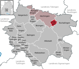
Hechingen
- municipality in Germany
Hiking in Hechingen
Hechingen, located in the Swabian Jura region of Germany, offers some beautiful hiking opportunities with diverse landscapes, rich history, and scenic views. Here's an overview of what you might expect when hiking in this area:...
- Country:
- Postal Code: 72371–72379
- Local Dialing Code: 07471
- Coordinates: 48° 21' 6" N, 8° 57' 48" E
- GPS tracks (wikiloc): [Link]
- AboveSeaLevel: 528 м m
- Area: 66.44 sq km
- Population: 18839
- Web site: [Link]


Haigerloch
- municipality in Germany
Hiking in Haigerloch
Haigerloch is a charming town located in the Baden-Württemberg region of Germany, known for its scenic landscapes and rich history. The area offers a variety of hiking opportunities that cater to different skill levels and preferences....
- Country:
- Postal Code: 72401
- Local Dialing Code: 07474
- Licence Plate Code: BL
- Coordinates: 48° 21' 53" N, 8° 48' 18" E
- GPS tracks (wikiloc): [Link]
- AboveSeaLevel: 482 м m
- Area: 76.46 sq km
- Population: 10637
- Web site: [Link]

Dautmergen
- municipality in Germany
Hiking in Dautmergen
Dautmergen is a small municipality in Baden-Württemberg, Germany, known for its beautiful landscapes and proximity to various hiking trails. While it may not be as well-known as some larger hiking destinations, it offers a charming rural atmosphere and scenic views, making it a great spot for outdoor enthusiasts....
- Country:
- Postal Code: 72356
- Local Dialing Code: 07427
- Licence Plate Code: BL
- Coordinates: 48° 14' 35" N, 8° 44' 27" E
- GPS tracks (wikiloc): [Link]
- AboveSeaLevel: 608 м m
- Area: 4.54 sq km
- Population: 403
- Web site: [Link]


Dotternhausen
- municipality in Germany
Hiking in Dotternhausen
Dotternhausen is a charming village located in the Baden-Württemberg region of Germany, surrounded by picturesque landscapes that offer great hiking opportunities. The area features a range of trails suitable for various skill levels, from leisurely walks to more challenging hikes....
- Country:
- Postal Code: 72359
- Local Dialing Code: 07427
- Licence Plate Code: BL
- Coordinates: 48° 13' 43" N, 8° 47' 31" E
- GPS tracks (wikiloc): [Link]
- AboveSeaLevel: 651 м m
- Area: 10.00 sq km
- Population: 1856
- Web site: [Link]


Meßstetten
- municipality in Germany
Hiking in Meßstetten
Meßstetten is a charming town located in the Swabian Jura region of Baden-Württemberg, Germany. It provides a beautiful backdrop for hiking enthusiasts, with diverse landscapes that include forests, hills, and scenic viewpoints. Here are some key points to consider when hiking in the Meßstetten area:...
- Country:
- Postal Code: 72469
- Local Dialing Code: 07579; 07436; 07431
- Licence Plate Code: BL
- Coordinates: 48° 10' 50" N, 8° 57' 45" E
- GPS tracks (wikiloc): [Link]
- AboveSeaLevel: 907 м m
- Area: 76.8 sq km
- Population: 10563
- Web site: [Link]


Bitz
- municipality in Germany
Hiking in Bitz
Bitz is a small town located in the Swabian Jura region of Germany. This area is known for its beautiful landscapes, rolling hills, and diverse natural environments, making it a great destination for hiking enthusiasts. Here are some key points to consider if you're interested in hiking in and around Bitz:...
- Country:
- Postal Code: 72475
- Local Dialing Code: 07431
- Licence Plate Code: BL
- Coordinates: 48° 14' 38" N, 9° 5' 29" E
- GPS tracks (wikiloc): [Link]
- AboveSeaLevel: 883 м m
- Area: 8.82 sq km
- Population: 3627
- Web site: [Link]


Dormettingen
- municipality in Germany
Hiking in Dormettingen
Dormettingen is a small municipality located in the Baden-Württemberg region of Germany, known for its picturesque landscapes and proximity to the Swabian Alps. Hiking in this area can be a delightful experience for outdoor enthusiasts, offering a variety of trails that showcase the natural beauty of the region....
- Country:
- Postal Code: 72358
- Local Dialing Code: 07427
- Licence Plate Code: BL
- Coordinates: 48° 14' 13" N, 8° 46' 24" E
- GPS tracks (wikiloc): [Link]
- AboveSeaLevel: 651 м m
- Area: 6.55 sq km
- Population: 1039
- Web site: [Link]


Hausen am Tann
- municipality in Germany
Hiking in Hausen am Tann
Hausen am Tann is a lovely village located in the Baden-Württemberg region of Germany, surrounded by picturesque natural landscapes that make it a great spot for hiking enthusiasts. The area offers a variety of trails suitable for different skill levels, from easy walks to more challenging hikes....
- Country:
- Postal Code: 72361
- Local Dialing Code: 07436
- Licence Plate Code: BL
- Coordinates: 48° 11' 54" N, 8° 50' 12" E
- GPS tracks (wikiloc): [Link]
- AboveSeaLevel: 745 м m
- Area: 8.49 sq km
- Population: 470
- Web site: [Link]


Weilen unter den Rinnen
- municipality in Germany
Hiking in Weilen unter den Rinnen
Weilen unter den Rinnen, a small village in Germany, is situated in the picturesque landscape of the Swabian Jura. While it may not be a well-known hiking destination, the surrounding region offers several opportunities for hiking enthusiasts looking to explore natural beauty, quaint villages, and historical sites....
- Country:
- Postal Code: 72367
- Local Dialing Code: 07427
- Licence Plate Code: BL
- Coordinates: 48° 11' 22" N, 8° 45' 53" E
- GPS tracks (wikiloc): [Link]
- AboveSeaLevel: 707 м m
- Area: 3.08 sq km
- Population: 597
- Web site: [Link]


Straßberg
- municipality in Germany
Hiking in Straßberg
Straßberg, located in the Zollernalbkreis region of Baden-Württemberg, Germany, offers a wonderful backdrop for hiking enthusiasts. The area is characterized by its beautiful landscapes, rolling hills, dense forests, and charming villages, making it a great destination for outdoor activities....
- Country:
- Postal Code: 72479
- Local Dialing Code: 07434
- Licence Plate Code: BL
- Coordinates: 48° 10' 49" N, 9° 5' 16" E
- GPS tracks (wikiloc): [Link]
- AboveSeaLevel: 682 м m
- Area: 24.91 sq km
- Population: 2460
- Web site: [Link]


Geislingen
- town in the Zollernalb district of Baden-Württemberg, Germany
Hiking in Geislingen
Geislingen, located in the Zollernalbkreis district of Baden-Württemberg, Germany, is an excellent place for hiking enthusiasts. This region is characterized by its picturesque landscapes, rolling hills, dense forests, and charming villages. Here are some key highlights and tips for hiking in and around Geislingen:...
- Country:
- Postal Code: 72349–72351
- Local Dialing Code: 07428; 07433
- Licence Plate Code: BL
- Coordinates: 48° 17' 15" N, 8° 48' 45" E
- GPS tracks (wikiloc): [Link]
- AboveSeaLevel: 563 м m
- Area: 31.95 sq km
- Population: 5932
- Web site: [Link]


Bisingen
- municipality in Germany
Hiking in Bisingen
Bisingen is a small town located in Baden-Württemberg, Germany, near the Swabian Jura mountain range, which offers diverse hiking opportunities. The surrounding area is characterized by beautiful landscapes, including forests, cliffs, and picturesque valleys, making it an excellent destination for hikers of all levels....
- Country:
- Postal Code: 72406
- Local Dialing Code: 07471; 07476
- Licence Plate Code: BL
- Coordinates: 48° 18' 43" N, 8° 55' 4" E
- GPS tracks (wikiloc): [Link]
- AboveSeaLevel: 561 м m
- Area: 32.84 sq km
- Population: 9423
- Web site: [Link]

Jungingen
- municipality in Germany
Hiking in Jungingen
Jungingen, a small town in the state of Baden-Württemberg in Germany, offers a variety of hiking opportunities for outdoor enthusiasts. Nestled in the beautiful Swabian Jura, the area is characterized by rolling hills, lush forests, and scenic landscapes, making it an ideal location for hiking....
- Country:
- Postal Code: 72417
- Local Dialing Code: 07477
- Licence Plate Code: BL
- Coordinates: 48° 19' 44" N, 9° 2' 33" E
- GPS tracks (wikiloc): [Link]
- AboveSeaLevel: 590 м m
- Area: 9.33 sq km
- Population: 1361
- Web site: [Link]

Winterlingen
- municipality in Germany
Hiking in Winterlingen
Winterlingen, located in the Swabian Jura of Baden-Württemberg, Germany, offers a variety of hiking opportunities that are perfect for both casual walkers and serious hikers. The region is characterized by its beautiful landscape featuring rolling hills, dense forests, and picturesque meadows, making it ideal for outdoor activities year-round....
- Country:
- Postal Code: 72470–72474
- Local Dialing Code: 07434
- Licence Plate Code: BL
- Coordinates: 48° 11' 0" N, 9° 7' 0" E
- GPS tracks (wikiloc): [Link]
- AboveSeaLevel: 789 м m
- Area: 50.64 sq km
- Population: 6356
- Web site: [Link]


Obernheim
- municipality in Germany
Hiking in Obernheim
Obernheim is a charming village located in the state of Baden-Württemberg, Germany. It is situated in the scenic region of the Swabian Jura, which offers a variety of hiking opportunities for outdoor enthusiasts. Here are some key points and tips for hiking in and around Obernheim:...
- Country:
- Postal Code: 72364
- Local Dialing Code: 07436
- Licence Plate Code: BL
- Coordinates: 48° 9' 45" N, 8° 51' 42" E
- GPS tracks (wikiloc): [Link]
- AboveSeaLevel: 897 м m
- Area: 15.02 sq km
- Population: 1437
- Web site: [Link]


Rangendingen
- municipality in Germany
Hiking in Rangendingen
Rangendingen is a charming village located in the Zollernalbkreis district of Baden-Württemberg, Germany. The surrounding area is known for its beautiful landscapes, making it a great destination for hiking enthusiasts....
- Country:
- Postal Code: 72412–72414
- Local Dialing Code: 07471
- Licence Plate Code: BL
- Coordinates: 48° 22' 52" N, 8° 53' 20" E
- GPS tracks (wikiloc): [Link]
- AboveSeaLevel: 421 м m
- Area: 21.67 sq km
- Population: 5109
- Web site: [Link]

Schömberg
- municipality in the Zollernalb district of Baden-Württemberg, Germany
Hiking in Schömberg
Schömberg, located in the Zollernalbkreis district of Baden-Württemberg, Germany, offers a variety of hiking opportunities that showcase the natural beauty and charm of the Swabian Jura region. Here's an overview of what you can expect when hiking in and around Schömberg:...
- Country:
- Postal Code: 72355
- Local Dialing Code: 07427
- Licence Plate Code: BL
- Coordinates: 48° 12' 41" N, 8° 45' 42" E
- GPS tracks (wikiloc): [Link]
- AboveSeaLevel: 676 м m
- Area: 23.27 sq km
- Population: 4644
- Web site: [Link]


Grosselfingen
- municipality in Germany
Hiking in Grosselfingen
Grosselfingen is a charming small village located in the Swabian region of Germany. Nestled in the picturesque landscape of the Swabian Jura, it offers a variety of hiking opportunities suitable for different skill levels....
- Country:
- Postal Code: 72415
- Local Dialing Code: 07476
- Licence Plate Code: BL
- Coordinates: 48° 19' 57" N, 8° 53' 12" E
- GPS tracks (wikiloc): [Link]
- AboveSeaLevel: 520 м m
- Area: 16.15 sq km
- Population: 2195
- Web site: [Link]


Albstadt
- city in the district of Zollernalbkreis in Baden-Württemberg, Germany
Hiking in Albstadt
Albstadt, located in the Swabian Jura region of Baden-Württemberg, Germany, offers a variety of hiking opportunities characterized by beautiful landscapes, diverse trails, and rich natural and cultural heritage. Here are some highlights for hiking in Albstadt:...
- Country:
- Postal Code: 72458–72461
- Local Dialing Code: 07435; 07432; 07431
- Licence Plate Code: BL
- Coordinates: 48° 12' 43" N, 9° 1' 26" E
- GPS tracks (wikiloc): [Link]
- AboveSeaLevel: 731 м m
- Area: 134.41 sq km
- Population: 44431
- Web site: [Link]
Shares border with regions:


Tuttlingen
- district of Baden-Württemberg, Germany
Hiking in Tuttlingen
Tuttlingen district, located in the southwestern part of Germany, is a beautiful region known for its diverse landscapes, including hills, forests, and rivers. This area is part of the Swabian Jura (Schwäbische Alb), making it an excellent destination for hiking enthusiasts....
- Country:
- Capital: Tuttlingen
- Licence Plate Code: TUT
- Coordinates: 48° 0' 0" N, 8° 48' 0" E
- GPS tracks (wikiloc): [Link]
- AboveSeaLevel: 831 м m
- Area: 734.40 sq km
- Population: 132476
- Web site: [Link]
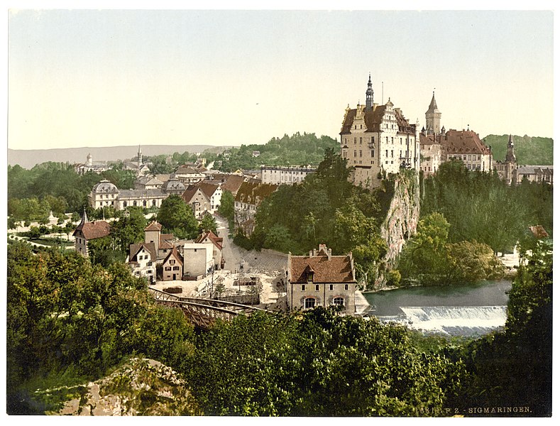

Landkreis Sigmaringen
- district of Baden-Württemberg, Germany
Hiking in Landkreis Sigmaringen
Sigmaringen, located in the southwestern part of Germany in the state of Baden-Württemberg, offers a beautiful and diverse landscape for hiking enthusiasts. The region is characterized by its stunning natural scenery, which includes rolling hills, dense forests, and picturesque valleys along the Danube River. Here are some highlights for hiking in the Sigmaringen district:...
- Country:
- Capital: Sigmaringen
- Licence Plate Code: SIG
- Coordinates: 48° 4' 48" N, 9° 10' 12" E
- GPS tracks (wikiloc): [Link]
- AboveSeaLevel: 626 м m
- Area: 1204.36 sq km
- Population: 127272
- Web site: [Link]