.JPG)
Arâches-la-Frasse (Arâches-la-Frasse)

- коммуна во Франции
 Hiking in Arâches-la-Frasse
Arâches-la-Frasse is a charming commune located in the Haute-Savoie region of the French Alps. It is known for its stunning landscapes and proximity to the Grand Massif ski area, which also offers numerous hiking opportunities during the warmer months.
Hiking Highlights:
-
Scenic Trails: The area features various trails suitable for all levels of hikers, from leisurely walks to challenging hikes. Popular trails often offer breathtaking views of the surrounding mountains, valleys, and forests.
-
Grand Massif: This ski area becomes a hiking paradise in summer, with well-marked trails. You can explore routes that take you through picturesque alpine pastures and enjoy views of Mont Blanc on clear days.
-
Nature and Wildlife: While hiking, keep an eye out for local wildlife, including deer, marmots, and various bird species. The diverse flora adds to the beauty of the trails, especially in late spring and summer when wildflowers bloom.
-
Lac de Gers: This stunning mountain lake can be accessed via a short hike and provides a perfect spot for a picnic or resting while soaking in the mountain scenery.
-
Local Culture: Along the trails, you might encounter traditional alpine chalets and local farms, where you can learn about local cheese and other culinary specialties.
Tips for Hiking in Arâches-la-Frasse:
-
Check Weather Conditions: The alpine weather can change rapidly, so it’s important to check forecasts and be prepared for varying conditions.
-
Proper Gear: Wear good hiking boots, and dress in layers. A waterproof jacket is advisable, even in summer, and don't forget sun protection.
-
Stay Hydrated and Nourished: Bring enough water and snacks, especially if you plan on taking longer hikes.
-
Trail Maps and Guides: It's useful to have a map or a hiking app, as well as information on trail difficulty and estimated times. Local tourist offices can provide helpful resources.
-
Respect Nature: Stick to marked trails, take your waste with you, and respect wildlife and plant life.
By following these tips and preparing adequately, you can enjoy a fantastic hiking experience in the beautiful setting of Arâches-la-Frasse!
- Страна:

- Почтовый код: 74300
- Координаты: 46° 2' 36" N, 6° 37' 53" E


- GPS треки (wikiloc): [Ссылка]
- Площадь: 37.69 кв.км
- Население: 1928
- Википедия английская: wiki(en)
- Википедия национальная: wiki(fr)
- Хранилище Wikidata: Wikidata: Q639578
- Катеория в википедии: [Ссылка]
- код Freebase: [/m/0gf2t8]
- код GeoNames: Альт: [6451008]
- номер SIREN: [217400142]
- код BNF: [15274274q]
- код VIAF: Альт: [313413356]
- ID отношения в OpenStreetMap: [104895]
- идентификатор местоположения ArchINFORM: [14083]
- место в MusicBrainz: [c532e244-c3db-4c28-874c-8d13f2a26a3c]
- код муниципалитета INSEE: 74014
Граничит с регионами:


Magland
- коммуна во Франции
Hiking in Magland
Magland, located in the Haute-Savoie region of France, is a beautiful destination for hiking enthusiasts. Nestled in the heart of the French Alps, this charming village offers stunning views, diverse terrains, and a range of hiking trails suitable for all skill levels. Here’s what you need to know about hiking in Magland:...
- Страна:
- Почтовый код: 74300
- Координаты: 46° 1' 19" N, 6° 37' 11" E
- GPS треки (wikiloc): [Ссылка]
- Площадь: 40.32 кв.км
- Население: 3301
- Веб сайт: [Ссылка]

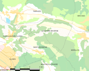
La Rivière-Enverse
- коммуна во Франции
Hiking in La Rivière-Enverse
La Rivière-Enverse is a picturesque village located in the Haute-Savoie region of France, offering stunning scenery and a range of hiking opportunities. Nestled in the French Alps, this area boasts a mix of lush valleys, dramatic peaks, and tranquil rivers. Here’s what you need to know about hiking in and around La Rivière-Enverse:...
- Страна:
- Почтовый код: 74440
- Координаты: 46° 5' 34" N, 6° 38' 11" E
- GPS треки (wikiloc): [Ссылка]
- Площадь: 7.98 кв.км
- Население: 457


Клюз
- коммуна во Франции
Hiking in Клюз
Cluses, located in the Haute-Savoie region of France, is a beautiful destination for hiking enthusiasts. Nestled in the heart of the Alps, it offers a variety of trails that cater to different skill levels and preferences. Here’s what you can expect when hiking in and around Cluses:...
- Страна:
- Почтовый код: 74300
- Координаты: 46° 3' 37" N, 6° 34' 43" E
- GPS треки (wikiloc): [Ссылка]
- Площадь: 10.46 кв.км
- Население: 17538
- Веб сайт: [Ссылка]


Самоэнс
- коммуна во Франции
Hiking in Самоэнс
Samoëns is a beautiful village located in the Haute-Savoie region of the French Alps. It is known for its stunning scenery, traditional architecture, and excellent outdoor recreational opportunities, making it a fantastic destination for hiking enthusiasts. Here are some key points to consider when hiking in Samoëns:...
- Страна:
- Почтовый код: 74340
- Координаты: 46° 5' 2" N, 6° 43' 38" E
- GPS треки (wikiloc): [Ссылка]
- Высота над уровнем моря: 710 м m
- Площадь: 97.29 кв.км
- Население: 2396
- Веб сайт: [Ссылка]


Сикст-Фер-а-Шеваль
- коммуна во Франции
Hiking in Сикст-Фер-а-Шеваль
Sixt-Fer-à-Cheval is a stunning location in the French Alps, renowned for its breathtaking scenery and well-maintained hiking trails. It's located in the Haute-Savoie region and is part of the larger Sixt-Fer-à-Cheval Nature Reserve, which boasts impressive geological formations, waterfalls, and lush green valleys....
- Страна:
- Почтовый код: 74740
- Координаты: 46° 3' 19" N, 6° 46' 32" E
- GPS треки (wikiloc): [Ссылка]
- Высота над уровнем моря: 760 м m
- Площадь: 119.07 кв.км
- Население: 775
- Веб сайт: [Ссылка]


Saint-Sigismond
- коммуна во Франции
Hiking in Saint-Sigismond
Saint-Sigismond, located in the Haute-Savoie region of the French Alps, offers a delightful experience for hikers and nature enthusiasts. This area is characterized by its stunning mountainous landscapes, lush greenery, and a variety of trails suitable for different skill levels. Here are some key points about hiking in Saint-Sigismond:...
- Страна:
- Почтовый код: 74300
- Координаты: 46° 4' 20" N, 6° 36' 52" E
- GPS треки (wikiloc): [Ссылка]
- Площадь: 7.92 кв.км
- Население: 595
- Веб сайт: [Ссылка]


Morillon
- коммуна во Франции
Hiking in Morillon
Morillon, a charming village in the French Alps, is part of the larger Grand Massif ski area, which is known not only for skiing but also for a variety of outdoor activities in the warmer months, including hiking. Here are some key points about hiking in Morillon:...
- Страна:
- Почтовый код: 74440
- Координаты: 46° 5' 2" N, 6° 40' 32" E
- GPS треки (wikiloc): [Ссылка]
- Площадь: 14.51 кв.км
- Население: 632
- Веб сайт: [Ссылка]