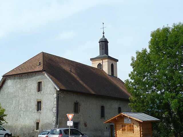
Scientrier (Scientrier)

- коммуна во Франции
 Hiking in Scientrier
Scientrier is a commune located in the Haute-Savoie department in the Auvergne-Rhône-Alpes region of southeastern France, near Lake Geneva. While it may not be as widely known as other hiking destinations in the region, it offers a variety of outdoor activities and trails that can appeal to hikers of all levels.
Hiking Opportunities in Scientrier:
-
Scenic Trails: The area surrounding Scientrier features trails that offer beautiful views of the mountains, valleys, and Lake Geneva. Many paths allow hikers to connect with nature and enjoy the local flora and fauna.
-
Nearby Mountains: The proximity to the Alps provides access to higher elevation trails. You can explore areas such as the Mont Blanc range or the Aravis mountains for more challenging hikes.
-
Local Nature Parks: Consider visiting nearby nature reserves and parks, which can provide marked hiking trails ranging from easy strolls to more difficult hikes, perfect for family outings or more serious adventurers.
-
Cultural Hiking: Some trails in the area may lead to historical sites, charming villages, or even vineyards, combining outdoor activity with cultural exploration.
-
Seasonal Hiking: Depending on the season, the hiking experience can vary greatly. Spring and summer offer lush greenery, while autumn displays vibrant foliage. Winter hiking can be tranquil but may require snow-specific equipment.
Tips for Hiking in Scientrier:
-
Check Trail Conditions: Before heading out, check the trail conditions, especially after heavy rainfall or snow, as some paths may be temporarily closed or require special gear.
-
Stay Hydrated: Carry enough water and snacks, especially on longer hikes, to keep your energy levels up.
-
Equipment: Good hiking boots and weather-appropriate clothing are essential, especially since conditions can change quickly in mountainous areas.
-
Navigation: Bring a map or GPS device as some trails can be less marked than in more popular tourist areas.
-
Respect Nature: Always follow Leave No Trace principles to maintain the natural beauty of the surroundings.
Whether you’re looking for a casual walk or a more strenuous trek, Scientrier and the surrounding regions have plenty to offer for hiking enthusiasts.
- Страна:

- Почтовый код: 74930
- Координаты: 46° 7' 8" N, 6° 18' 56" E


- GPS треки (wikiloc): [Ссылка]
- Площадь: 7.21 кв.км
- Население: 1156
- Википедия английская: wiki(en)
- Википедия национальная: wiki(fr)
- Хранилище Wikidata: Wikidata: Q845358
- Катеория в википедии: [Ссылка]
- код Freebase: [/m/03ntyq_]
- код GeoNames: Альт: [6443050]
- номер SIREN: [217402627]
- код BNF: [15274516c]
- код муниципалитета INSEE: 74262
Граничит с регионами:


Pers-Jussy
- коммуна во Франции
Hiking in Pers-Jussy
Pers-Jussy is a charming commune in the Haute-Savoie department of France, located near the city of Geneva, Switzerland. While it isn't as widely known as some major hiking destinations in the Alps, it offers access to beautiful landscapes and trails. Here's what you need to consider for hiking in and around Pers-Jussy:...
- Страна:
- Почтовый код: 74930
- Координаты: 46° 6' 26" N, 6° 16' 2" E
- GPS треки (wikiloc): [Ссылка]
- Площадь: 18.68 кв.км
- Население: 2997


Reignier-Esery
- коммуна во Франции
Hiking in Reignier-Esery
Reignier-Ésery is a charming commune located in the Haute-Savoie region of France, nestled between the city of Annecy and the French Alps. The area offers a variety of hiking opportunities, perfect for both beginners and experienced hikers. Here are some details and tips for hiking in and around Reignier-Ésery:...
- Страна:
- Почтовый код: 74930
- Координаты: 46° 8' 4" N, 6° 16' 6" E
- GPS треки (wikiloc): [Ссылка]
- Площадь: 25.08 кв.км
- Население: 7585
- Веб сайт: [Ссылка]


Arenthon
- коммуна во Франции
Hiking in Arenthon
Arenthon, located in the Haute-Savoie region of France, offers beautiful hiking opportunities amidst stunning alpine scenery. The area is characterized by lush green valleys, picturesque lakes, and views of the surrounding mountains, including the Mont Blanc range....
- Страна:
- Почтовый код: 74800
- Координаты: 46° 6' 21" N, 6° 19' 58" E
- GPS треки (wikiloc): [Ссылка]
- Площадь: 11.47 кв.км
- Население: 1606


Cornier
- коммуна во Франции
Hiking in Cornier
It seems there might be a small typo in your request, as there isn't a well-known hiking region called "Cornier." However, if you meant "Cornwall," I can provide information about hiking in that area. If there's a different location you were referring to, please let me know!...
- Страна:
- Почтовый код: 74800
- Координаты: 46° 5' 34" N, 6° 17' 59" E
- GPS треки (wikiloc): [Ссылка]
- Площадь: 6.78 кв.км
- Население: 1276
- Веб сайт: [Ссылка]

Nangy
- коммуна во Франции
Hiking in Nangy
Nangy, located in the Haute-Savoie department in the Auvergne-Rhône-Alpes region of France, offers a variety of hiking options that showcase stunning landscapes, charming alpine scenery, and a taste of the local culture....
- Страна:
- Почтовый код: 74380
- Координаты: 46° 9' 15" N, 6° 18' 23" E
- GPS треки (wikiloc): [Ссылка]
- Площадь: 4.35 кв.км
- Население: 1695
- Веб сайт: [Ссылка]

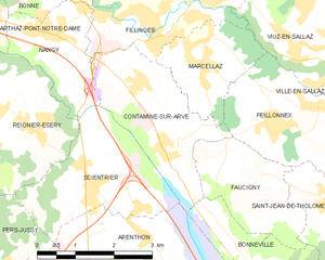
Contamine-sur-Arve
- коммуна во Франции
Hiking in Contamine-sur-Arve
Contamine-sur-Arve is a charming commune located in the Haute-Savoie region of France, near Mont Blanc. It offers a variety of hiking opportunities that cater to different skill levels and preferences. Here are some highlights and tips for hiking in and around Contamine-sur-Arve:...
- Страна:
- Почтовый код: 74130
- Координаты: 46° 7' 42" N, 6° 20' 26" E
- GPS треки (wikiloc): [Ссылка]
- Площадь: 6.92 кв.км
- Население: 1940
- Веб сайт: [Ссылка]