canton of Rumilly (canton de Rumilly)

 Hiking in canton of Rumilly
The Canton of Rumilly, located in the Haute-Savoie department in the Auvergne-Rhône-Alpes region of France, offers a variety of scenic hiking opportunities. This area is characterized by its stunning landscapes, including rolling hills, forests, lakes, and views of the surrounding mountains, including the Bauges massif and the Chartreuse mountains.
Hiking Highlights in the Canton of Rumilly:
-
Variety of Trails: The Canton of Rumilly provides a range of hiking trails suitable for different skill levels, from easy walks to more challenging hikes. Popular routes often lead to panoramic viewpoints or through picturesque villages.
-
Nature Reserves: The area is home to several protected natural spaces, such as the Regional Natural Park of the Bauges. This park is known for its biodiversity, featuring rich flora and fauna, making it a great destination for nature enthusiasts and wildlife watchers.
-
Lakes and Rivers: Hiking around Lake Annecy or the various smaller lakes like Lake Bourget can provide beautiful scenery and opportunities for a refreshing swim after a hike. The lakes are often linked by well-marked trails.
-
Cultural and Historical Sites: Many hikes in the area pass through charming towns and villages rich in history, allowing hikers to explore local culture and perhaps enjoy some regional cuisine.
-
Guided Tours and DIY Routes: For those unsure about where to start, there are guided hikes available, or you can opt for self-guided routes outlined in local hiking maps and apps.
Practical Tips:
- Weather: Always check the weather conditions before heading out, as mountain weather can change rapidly.
- Gear: Good walking shoes, a map, sufficient water, and snacks are essential. Depending on the season, also consider sun protection or warm clothing.
- Safety: Always let someone know your planned route and expected return time.
Popular Hikes in the Area:
- Mont Revard: A fantastic hike that offers breathtaking views of Lake Bourget and the surrounding mountains.
- Le Semnoz: Known for its beautiful alpine meadows, this area provides trails that are accessible in both summer and winter.
- Les Bauges: Explore various trails that wind through the Bauges Regional Park, ideal for those wanting to immerse themselves in nature.
Conclusion:
Hiking in the Canton of Rumilly allows you to experience the natural beauty of the French Alps, enjoy outdoor activities, and delve into the cultural richness of the region. Whether you're a seasoned hiker or a casual walker, this area has something to offer for everyone. Always ensure to plan your hikes accordingly and be prepared for changing conditions to have a safe and enjoyable experience.
- Страна:

- Столица: Rumilly
- Координаты: 45° 53' 31" N, 5° 57' 2" E


- GPS треки (wikiloc): [Ссылка]
- Население: 44297
- Википедия английская: wiki(en)
- Википедия национальная: wiki(fr)
- Хранилище Wikidata: Wikidata: Q1483138
- код кантона INSEE: [7412]
Включает регионы:


Bloye
- коммуна во Франции
Hiking in Bloye
Bloye is a charming village situated in the Haute-Savoie department of the Auvergne-Rhône-Alpes region in southeastern France. The surrounding area offers stunning natural landscapes, making it a great destination for hiking enthusiasts....
- Страна:
- Почтовый код: 74150
- Координаты: 45° 49' 34" N, 5° 56' 44" E
- GPS треки (wikiloc): [Ссылка]
- Площадь: 4.4 кв.км
- Население: 614

Vaulx
Hiking in Vaulx
Vaulx is a charming village located in the Haute-Savoie region of the French Alps, known for its stunning natural landscapes and proximity to the majestic mountains. Hiking in this area can be a delightful experience for both beginners and seasoned hikers....
- Страна:
- Почтовый код: 74150
- Координаты: 45° 55' 48" N, 5° 59' 44" E
- GPS треки (wikiloc): [Ссылка]
- Площадь: 11.19 кв.км
- Население: 952
- Веб сайт: [Ссылка]


Étercy
- коммуна во Франции
Hiking in Étercy
Étercy seems to be a lesser-known location, and as of my last update, there isn’t extensive information specifically on hiking routes or trails there. However, if Étercy is a place you’re interested in hiking, I can offer general tips and advice that may be helpful for hiking in any new area:...
- Страна:
- Почтовый код: 74150
- Координаты: 45° 53' 27" N, 6° 0' 34" E
- GPS треки (wikiloc): [Ссылка]
- Площадь: 4.55 кв.км
- Население: 788

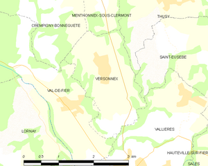
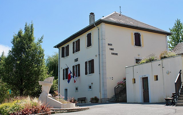
Versonnex, Haute-Savoie
Hiking in Versonnex, Haute-Savoie
Versonnex is a charming village in the Haute-Savoie region of the French Alps, known for its picturesque landscapes and proximity to nature. Here are some key points about hiking in and around Versonnex:...
- Страна:
- Почтовый код: 74150
- Координаты: 45° 55' 45" N, 5° 55' 37" E
- GPS треки (wikiloc): [Ссылка]
- Площадь: 4.18 кв.км
- Население: 610


Sales
- коммуна во Франции
Hiking in Sales
Sales, located in the Haute-Savoie region of the French Alps, offers an array of hiking opportunities set against a stunning mountainous backdrop. This area is known for its picturesque villages, lush landscapes, and accessible trails suitable for various skill levels. Here are some highlights and tips for hiking in Sales:...
- Страна:
- Почтовый код: 74150
- Координаты: 45° 52' 30" N, 5° 57' 37" E
- GPS треки (wikiloc): [Ссылка]
- Площадь: 9.21 кв.км
- Население: 1881
- Веб сайт: [Ссылка]


Marcellaz-Albanais
- коммуна во Франции
Hiking in Marcellaz-Albanais
Marcellaz-Albanais is a charming commune located in the Haute-Savoie department in the Auvergne-Rhône-Alpes region of southeastern France. Nestled in the foothills of the Alps, it offers beautiful landscapes and a variety of hiking opportunities for outdoor enthusiasts....
- Страна:
- Почтовый код: 74150
- Координаты: 45° 52' 29" N, 6° 0' 4" E
- GPS треки (wikiloc): [Ссылка]
- Площадь: 14.54 кв.км
- Население: 1861
- Веб сайт: [Ссылка]


Marigny-Saint-Marcel
- коммуна во Франции
Hiking in Marigny-Saint-Marcel
Marigny-Saint-Marcel is a charming commune located in the French region of Auvergne-Rhône-Alpes, offering beautiful landscapes and a rich natural environment ideal for hiking enthusiasts. Here are some highlights and tips for hiking in and around Marigny-Saint-Marcel:...
- Страна:
- Почтовый код: 74150
- Координаты: 45° 49' 45" N, 5° 59' 9" E
- GPS треки (wikiloc): [Ссылка]
- Площадь: 7.35 кв.км
- Население: 683
- Веб сайт: [Ссылка]


Vallières
- коммуна во Франции
Hiking in Vallières
Vallières, located in Haute-Savoie, offers a stunning backdrop for hiking enthusiasts. Nestled in the French Alps, this region is known for its picturesque landscapes, including lush valleys, rugged mountains, and charming alpine villages. Here are some key points to consider when hiking in Vallières:...
- Страна:
- Почтовый код: 74150
- Координаты: 45° 54' 1" N, 5° 56' 10" E
- GPS треки (wikiloc): [Ссылка]
- Площадь: 9.03 кв.км
- Население: 1781


Moye
- коммуна во Франции
Hiking in Moye
Moye is a beautiful area for hiking, known for its diverse landscapes and natural beauty. While I don’t have specific information on a location named Moye, it typically refers to various places, sometimes in Europe or other regions. If Moye is somewhere you have in mind, here are some general tips and considerations for hiking in such an area:...
- Страна:
- Почтовый код: 74150
- Координаты: 45° 52' 35" N, 5° 54' 43" E
- GPS треки (wikiloc): [Ссылка]
- Площадь: 23.8 кв.км
- Население: 1030


Boussy
- коммуна во Франции
Hiking in Boussy
Boussy is a picturesque village located in the Haute-Savoie region of France, known for its stunning alpine landscapes and proximity to the French Alps. Hiking in this area provides a wonderful opportunity to explore beautiful trails, enjoy breathtaking views, and experience the local flora and fauna....
- Страна:
- Почтовый код: 74150
- Координаты: 45° 51' 22" N, 5° 58' 59" E
- GPS треки (wikiloc): [Ссылка]
- Площадь: 5.23 кв.км
- Население: 499


Crempigny-Bonneguête
- коммуна во Франции
Hiking in Crempigny-Bonneguête
Crempigny-Bonneguête is a charming commune located in the Auvergne-Rhône-Alpes region of France, nestled in the beautiful countryside. While it may not be as well-known as some other hiking destinations in France, it offers opportunities for nature lovers and hikers to explore scenic trails, indulge in local flora and fauna, and enjoy the serenity of the area....
- Страна:
- Почтовый код: 74150
- Координаты: 45° 57' 6" N, 5° 54' 11" E
- GPS треки (wikiloc): [Ссылка]
- Площадь: 5.82 кв.км
- Население: 308
- Веб сайт: [Ссылка]

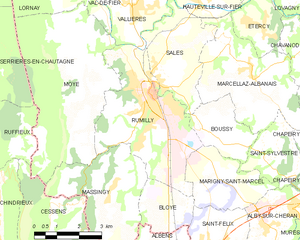
Rumilly
- коммуна во Франции
Hiking in Rumilly
Rumilly, located in the Haute-Savoie region of France, is a charming town surrounded by stunning landscapes that are ideal for hiking enthusiasts. Set against the backdrop of the French Alps, this area offers a variety of trails suitable for all levels of hikers, from beginners to experienced trekkers....
- Страна:
- Почтовый код: 74150
- Координаты: 45° 51' 58" N, 5° 56' 40" E
- GPS треки (wikiloc): [Ссылка]
- Площадь: 16.89 кв.км
- Население: 14931


Lornay
- коммуна во Франции
Hiking in Lornay
Lornay is a picturesque area located in the Auvergne-Rhône-Alpes region of France. It is characterized by its natural beauty, offering a variety of landscapes ranging from rolling hills to lush forests. Here are some key points about hiking in Lornay:...
- Страна:
- Почтовый код: 74150
- Координаты: 45° 54' 59" N, 5° 54' 6" E
- GPS треки (wikiloc): [Ссылка]
- Площадь: 9.65 кв.км
- Население: 536
Massingy
Hiking in Massingy
Massingy, located in the Haute-Savoie region of the French Alps, offers a beautiful backdrop for hiking enthusiasts. This area is known for its stunning natural scenery, characterized by rolling hills, lush forests, and panoramic views of the surrounding mountains, including the nearby Mont Blanc....
- Страна:
- Почтовый код: 74150
- Координаты: 45° 49' 47" N, 5° 55' 12" E
- GPS треки (wikiloc): [Ссылка]
- Площадь: 12.34 кв.км
- Население: 847


Hauteville-sur-Fier
- коммуна во Франции
Hiking in Hauteville-sur-Fier
Hauteville-sur-Fier, located in the Auvergne-Rhône-Alpes region of France, offers a variety of hiking opportunities that appeal to outdoor enthusiasts. The area is characterized by its stunning natural landscapes, rolling hills, and proximity to the beautiful Lake Bourget....
- Страна:
- Почтовый код: 74150
- Координаты: 45° 54' 13" N, 5° 58' 30" E
- GPS треки (wikiloc): [Ссылка]
- Площадь: 4.9 кв.км
- Население: 922
- Веб сайт: [Ссылка]

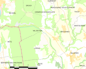
Val-de-Fier
- коммуна во Франции
Hiking in Val-de-Fier
Val-de-Fier is a beautiful natural area located in the French Alps, specifically in the Haute-Savoie region. It is known for its stunning landscapes, diverse flora and fauna, and a variety of hiking trails suitable for different skill levels. Here are some key points and tips for hiking in Val-de-Fier:...
- Страна:
- Почтовый код: 74150
- Координаты: 45° 55' 30" N, 5° 54' 18" E
- GPS треки (wikiloc): [Ссылка]
- Площадь: 10.11 кв.км
- Население: 666
- Веб сайт: [Ссылка]


Thusy
- коммуна во Франции
Hiking in Thusy
Thusy is a picturesque village located in the Haute-Savoie region of the French Alps. It serves as an excellent base for hikers seeking both stunning landscapes and a variety of trails. Here are some highlights and information about hiking in the Thusy area:...
- Страна:
- Почтовый код: 74150
- Координаты: 45° 56' 51" N, 5° 56' 56" E
- GPS треки (wikiloc): [Ссылка]
- Площадь: 10.74 кв.км
- Население: 1076
- Веб сайт: [Ссылка]


Saint-Eusèbe
- коммуна во Франции
Hiking in Saint-Eusèbe
Saint-Eusèbe, located in the Haute-Savoie region of the French Alps, offers beautiful hiking opportunities with stunning views of the surrounding mountains and valleys. Here are some key points to consider if you're planning a hike in this area:...
- Страна:
- Почтовый код: 74150
- Координаты: 45° 55' 46" N, 5° 57' 46" E
- GPS треки (wikiloc): [Ссылка]
- Площадь: 6.88 кв.км
- Население: 525