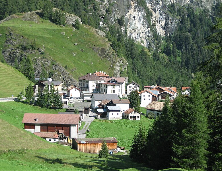
Марморера (Marmorera, Marmorera)

 Hiking in Марморера
Marmorera is a picturesque area located in the canton of Graubünden in Switzerland, known for its stunning landscapes, diverse hiking trails, and tranquil atmosphere. Here are some key points to consider if you're planning to hike in Marmorera:
Trails and Routes
-
Variety of Trails: Marmorera offers a range of hiking trails suitable for different skill levels, from easy walks to challenging treks. You can find marked paths that take you through enchanting forests, alpine meadows, and alongside beautiful lakes.
-
Breathtaking Views: Many trails in the Marmorera region provide breathtaking views of the surrounding mountains and valleys, including the stunning Piz Poble and the Landwasser Valley.
-
Marmorera Lake: The Marmorera Lake is a popular spot for hiking. You can take a leisurely walk around the lake or explore the nearby trails that lead into the scenic landscapes.
-
Connecting Trails: The area is well-connected to other hiking trails in the region, allowing you to extend your hikes and explore nearby areas like the Surses Valley.
Best Hiking Seasons
- Summer (June to September): The best time for hiking in Marmorera is during the summer months when trails are clear of snow and wildflowers are in bloom.
- Autumn (October): Early autumn can also be a great time to hike, offering beautiful fall foliage and cooler temperatures.
Preparation and Safety
- Weather Conditions: Always check the weather forecast before heading out, as conditions in the mountains can change rapidly.
- Gear: Wear sturdy hiking boots, dress in layers, and bring essentials like water, snacks, a map, and a first-aid kit.
- Trail Etiquette: Respect local guidelines and keep to marked trails, especially in protected areas.
Additional Activities
In addition to hiking, Marmorera offers opportunities for activities like mountain biking, fishing, and even swimming in the lake during the warmer months.
Accessibility
Marmorera is accessible by public transport and private vehicles. The nearest larger towns have train and bus connections, making it relatively easy to reach the area.
Overall, hiking in Marmorera provides a fantastic opportunity to connect with nature and enjoy the stunning beauty of the Swiss Alps. Whether you're looking for a gentle stroll or a more rigorous hike, Marmorera has something for everyone.
- Страна:

- Почтовый код: 7456
- Телефонный код: 081
- Код автомобильного номера: GR
- Координаты: 46° 29' 59" N, 9° 39' 0" E


- GPS треки (wikiloc): [Ссылка]
- Высота над уровнем моря: 1720 м m
- Площадь: 18.90 кв.км
- Веб сайт: http://www.marmorera.ch
- Википедия русская: wiki(ru)
- Википедия английская: wiki(en)
- Википедия национальная: wiki(de)
- Хранилище Wikidata: Wikidata: Q65112
- Катеория в википедии: [Ссылка]
- код Freebase: [/m/026fkrc]
- код GeoNames: Альт: [2659757]
- код VIAF: Альт: [244718035]
- идентификатор HDS: [1424]
- код швейцарского муниципалитета: [3533]
Граничит с регионами:


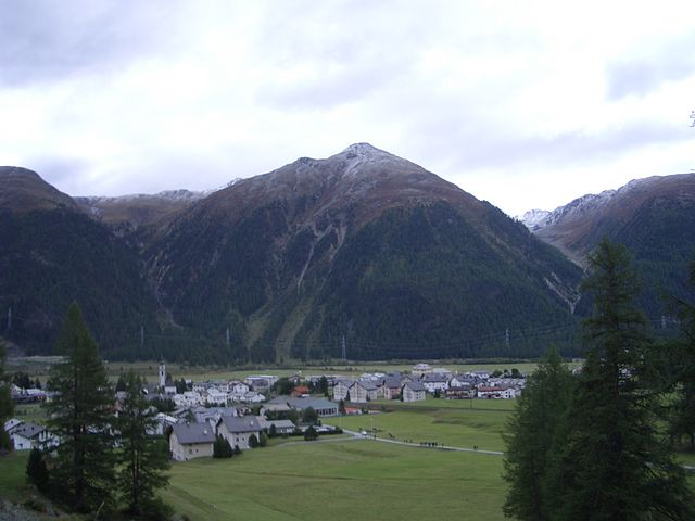
Сур
Hiking in Сур
Sur is a charming village located in the Swiss canton of Grisons (Graubünden) and offers impressive hiking opportunities, primarily for those who love the beautiful landscapes of the Swiss Alps. Here’s an overview of what you can expect:...
- Страна:
- Почтовый код: 7456
- Телефонный код: 081
- Код автомобильного номера: GR
- Координаты: 46° 30' 59" N, 9° 36' 59" E
- GPS треки (wikiloc): [Ссылка]
- Высота над уровнем моря: 1530 м m
- Площадь: 23.22 кв.км
- Веб сайт: [Ссылка]

Мулегнс
Hiking in Мулегнс
Mulegns, a picturesque village nestled in the Swiss Alps, offers fantastic hiking opportunities for outdoor enthusiasts. It is known for its stunning alpine scenery, lush meadows, and well-marked trails suitable for various skill levels. Here are some highlights of hiking in Mulegns:...
- Страна:
- Почтовый код: 7455
- Телефонный код: 081
- Код автомобильного номера: GR
- Координаты: 46° 30' 16" N, 9° 34' 46" E
- GPS треки (wikiloc): [Ссылка]
- Высота над уровнем моря: 1952 м m
- Площадь: 33.79 кв.км


Бивио
Hiking in Бивио
Bivio is a charming village located in the Swiss Alps, known for its stunning natural landscapes and excellent hiking opportunities. Situated at the junction of several hiking trails, Bivio serves as a gateway to the surrounding mountains and valleys, making it a popular destination for outdoor enthusiasts....
- Страна:
- Почтовый код: 7457
- Телефонный код: 081
- Код автомобильного номера: GR
- Координаты: 46° 28' 11" N, 9° 39' 4" E
- GPS треки (wikiloc): [Ссылка]
- Высота над уровнем моря: 1769 м m
- Площадь: 76.73 кв.км
- Веб сайт: [Ссылка]

Бевер
- коммуна
Hiking in Бевер
Bever, Switzerland, is a charming village located in the Engadin Valley and is part of the UNESCO Biosphere Reserve. It offers incredible hiking opportunities amidst stunning alpine scenery, making it an attractive destination for both novice and seasoned hikers. Here are some key details about hiking in Bever:...
- Страна:
- Почтовый код: 7502
- Телефонный код: 081
- Код автомобильного номера: GR
- Координаты: 46° 32' 59" N, 9° 52' 59" E
- GPS треки (wikiloc): [Ссылка]
- Высота над уровнем моря: 2653 м m
- Площадь: 47.75 кв.км
- Население: 598
- Веб сайт: [Ссылка]