canton of Bourgoin-Jallieu-Sud (canton de Bourgoin-Jallieu-Sud)
 Hiking in canton of Bourgoin-Jallieu-Sud
Canton de Bourgoin-Jallieu-Sud, located in the Isère department in the Auvergne-Rhône-Alpes region of France, offers a variety of hiking opportunities for both beginners and seasoned hikers. The landscape is characterized by rolling hills, forests, and picturesque countryside, making it an inviting area for outdoor exploration.
Key Highlights for Hiking in Canton de Bourgoin-Jallieu-Sud:
-
Scenic Trails: The area features numerous marked trails that cater to different skill levels. Trails often provide stunning views of the surrounding countryside and mountains. Pay attention to local maps and signage for the best routes.
-
Natural Parks: The proximity to regional natural parks, such as the Chartreuse and Vercors, allows for extended hiking excursions and the opportunity to explore a diversity of ecosystems.
-
Historical Sites: Along the trails, you may encounter historical sites, including old farms, chapels, and ruins, adding a cultural element to your hiking experience.
-
Family-Friendly Routes: Many trails are suitable for families, offering shorter loops that are easy to navigate and enjoy. These trails often have picnic spots and rest areas.
-
Wildlife and Flora: The region is rich in biodiversity, making hikes a great opportunity for bird watching and appreciating local flora. Look out for various plant species and wildlife typical to the Rhône-Alpes region.
-
Local Resources: Before heading out, check local tourist offices for trail maps, recommended routes, and information on any guided hikes that may be available.
Tips for Hiking:
- Wear Appropriate Gear: Good hiking boots and weather-appropriate clothing are essential. The weather can change quickly, so be prepared.
- Stay Hydrated: Always carry enough water, especially if you're planning a longer hike.
- Leave No Trace: Follow the Leave No Trace principles to keep the trails clean and preserve the natural beauty for others.
- Plan Your Hike: Familiarize yourself with the trail map and difficulty levels. It’s advisable to let someone know your hiking plans before heading out.
Best Time to Hike:
The best times for hiking in this region are typically during spring (April to June) and autumn (September to November) when weather conditions are generally mild, and the landscapes are particularly beautiful with blooming flora or fall colors.
Whether you are looking for a short nature walk or an adventurous day hike, Canton de Bourgoin-Jallieu-Sud has something to offer all hiking enthusiasts. Enjoy your time exploring the beauty of this region!
- Страна:

- Столица: Бургуэн-Жальё
- Координаты: 45° 33' 14" N, 5° 17' 11" E


- GPS треки (wikiloc): [Ссылка]
- Хранилище Wikidata: Wikidata: Q1724576
- код кантона INSEE: [3804]
Включает регионы:


Домарен
- коммуна во Франции
Hiking in Домарен
Domarin is a small town located in Slovenia, surrounded by stunning natural landscapes ideal for hiking enthusiasts. The area offers a variety of trails suitable for different skill levels, making it a great destination for both beginners and experienced hikers....
- Страна:
- Почтовый код: 38300
- Координаты: 45° 35' 8" N, 5° 14' 39" E
- GPS треки (wikiloc): [Ссылка]
- Площадь: 2.99 кв.км
- Население: 1556
- Веб сайт: [Ссылка]


Бадиньер
- коммуна во Франции
Hiking in Бадиньер
Badinières is not a widely recognized hiking destination, but it could possibly refer to a local area or a specific site depending on the region you're interested in. If you meant a specific region, please provide more details about the location or clarify if "Badinières" is a term used in a broader hiking context, such as a trail, park, or nearby mountain range....
- Страна:
- Почтовый код: 38300
- Координаты: 45° 30' 36" N, 5° 18' 11" E
- GPS треки (wikiloc): [Ссылка]

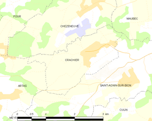
Крашье
- коммуна во Франции
Hiking in Крашье
Crachier, though not widely known, may refer to hiking areas in regions with picturesque landscapes and trails. If you're interested in a specific location with that name or similar sounding places, I could help you explore general hiking tips and information about various renowned hiking spots....
- Страна:
- Почтовый код: 38300
- Координаты: 45° 32' 54" N, 5° 13' 32" E
- GPS треки (wikiloc): [Ссылка]
- Площадь: 3.64 кв.км
- Население: 494
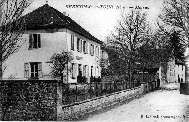

Серезен-де-ла-Тур
- коммуна во Франции
Hiking in Серезен-де-ла-Тур
Sérézin-de-la-Tour, nestled in the Auvergne-Rhône-Alpes region of France, offers charming hiking opportunities that attract both locals and visitors. The area is characterized by beautiful natural landscapes, including rolling hills, forests, and scenic views of the surrounding countryside....
- Страна:
- Почтовый код: 38300
- Координаты: 45° 33' 27" N, 5° 20' 39" E
- GPS треки (wikiloc): [Ссылка]
- Площадь: 9.31 кв.км
- Население: 1011
- Веб сайт: [Ссылка]


Сент-Альбан-де-Рош
- коммуна во Франции
Hiking in Сент-Альбан-де-Рош
Saint-Alban-de-Roche is a charming commune located in the Auvergne-Rhône-Alpes region of France, near the city of Bourgoin-Jallieu. The area is characterized by its beautiful landscapes and a mix of rural and suburban environments, making it an attractive destination for hiking enthusiasts....
- Страна:
- Почтовый код: 38300
- Координаты: 45° 35' 46" N, 5° 13' 27" E
- GPS треки (wikiloc): [Ссылка]
- Площадь: 6.11 кв.км
- Население: 1905
- Веб сайт: [Ссылка]


Ниволас-Вермель
- коммуна во Франции
Hiking in Ниволас-Вермель
Nivolas-Vermelle is a charming commune located in the Auvergne-Rhône-Alpes region of southeastern France. While it may not be as widely known for hiking as some other regions in the Alps, it still offers beautiful natural surroundings and various outdoor activities....
- Страна:
- Почтовый код: 38300
- Координаты: 45° 33' 24" N, 5° 18' 23" E
- GPS треки (wikiloc): [Ссылка]
- Площадь: 6.09 кв.км
- Население: 2536
- Веб сайт: [Ссылка]


Мобек
- коммуна во Франции
Hiking in Мобек
Maubec, a small commune in the department of Isère in the Auvergne-Rhône-Alpes region of France, offers a charming backdrop for hiking enthusiasts. Nestled in the picturesque French Alps, it provides access to a variety of trails suitable for different skill levels, ranging from easy walks to more challenging hikes....
- Страна:
- Почтовый код: 38300
- Координаты: 45° 34' 6" N, 5° 15' 57" E
- GPS треки (wikiloc): [Ссылка]
- Площадь: 8.57 кв.км
- Население: 1704
- Веб сайт: [Ссылка]


Лез-Эпарр
- коммуна во Франции
Hiking in Лез-Эпарр
Les Éparres, located in the southeastern region of France near the Vercors Massif, offers beautiful landscapes and a variety of hiking trails suitable for different skill levels. The area is characterized by its stunning views, diverse flora and fauna, and the unique geological features of the region....
- Страна:
- Почтовый код: 38300
- Координаты: 45° 32' 1" N, 5° 17' 34" E
- GPS треки (wikiloc): [Ссылка]
- Площадь: 7.95 кв.км
- Население: 987


Мерье
- коммуна во Франции
Hiking in Мерье
Meyrié is a lesser-known gem for hikers, often appreciated for its natural beauty and tranquility. Located in the French Alps, it offers a range of hiking trails suitable for different skill levels, from leisurely strolls to more challenging treks....
- Страна:
- Почтовый код: 38300
- Координаты: 45° 33' 34" N, 5° 17' 14" E
- GPS треки (wikiloc): [Ссылка]
- Площадь: 3.43 кв.км
- Население: 1022
- Веб сайт: [Ссылка]


Шатовьен
- коммуна во Франции
Hiking in Шатовьен
Châteauvilain, located in the beautiful region of France, is known for its picturesque landscapes and hiking opportunities. While specific trails and conditions may vary, here are some general insights into hiking in the area:...
- Страна:
- Почтовый код: 38300
- Координаты: 45° 31' 0" N, 5° 19' 48" E
- GPS треки (wikiloc): [Ссылка]
- Высота над уровнем моря: 500 м m
- Площадь: 8.82 кв.км
- Население: 701
- Веб сайт: [Ссылка]
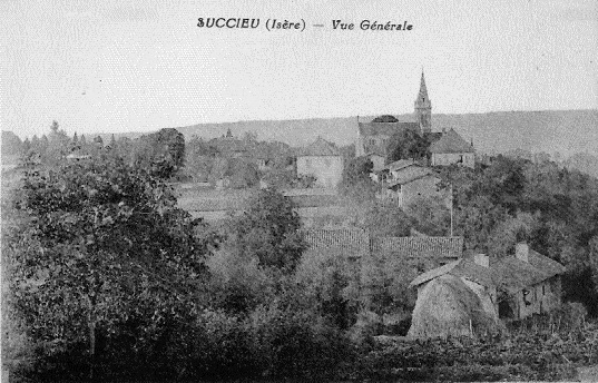
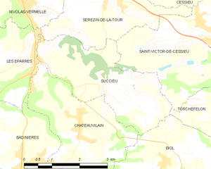
Сюксьё
- коммуна во Франции
Hiking in Сюксьё
Succieu is a charming village located in the Auvergne-Rhône-Alpes region of France, surrounded by beautiful landscapes that make it an appealing destination for hiking enthusiasts. While it may not be as well-known as some larger hiking areas, it offers a variety of trails that showcase the natural beauty of the region....
- Страна:
- Почтовый код: 38300
- Координаты: 45° 31' 40" N, 5° 20' 20" E
- GPS треки (wikiloc): [Ссылка]
- Площадь: 8.35 кв.км
- Население: 728
- Веб сайт: [Ссылка]