Лез-Эпарр (Les Éparres, Les Éparres)

- коммуна во Франции
 Hiking in Лез-Эпарр
Les Éparres, located in the southeastern region of France near the Vercors Massif, offers beautiful landscapes and a variety of hiking trails suitable for different skill levels. The area is characterized by its stunning views, diverse flora and fauna, and the unique geological features of the region.
Hiking Trails
-
Circuit des Crêtes: This trail provides panoramic views of the surrounding mountains and valleys. It’s a moderate hike that takes you along the ridge line for breathtaking scenery.
-
Le Chemin des Dames: A historical trail with educational signage about the area's historical significance and natural features. It’s a family-friendly path that is suitable for all ages.
-
Sentier des Gorges: This more challenging trail leads you through the dramatic gorges of Les Éparres, where you can experience the area's rugged beauty and possibly spot local wildlife.
What to Bring
- Hiking Boots: Ensure you have sturdy footwear for comfort and support on varied terrain.
- Water: Stay hydrated; carry enough water, especially on warmer days.
- Snacks: Bring energy-boosting snacks to keep your energy levels up.
- Map or GPS: Familiarize yourself with the trails, and consider downloading a map or bringing a physical one.
- Sun Protection: Sunscreen, a hat, and sunglasses are recommended, especially on open trails.
Season and Weather
- Spring and early autumn are ideal times to hike in Les Éparres, as the weather is typically mild and the landscapes are often vibrant with blossoms and fall colors.
- Summer can be warm, so early morning hikes might be the best option to avoid the heat.
- Winter hiking can also be an option, but be prepared for snow and icy conditions.
Safety Tips
- Always inform someone about your hiking plans.
- Be mindful of trail signage and local regulations.
- If you're unfamiliar with the area, consider hiking with a guide or joining a local hiking group.
Conclusion
Les Éparres is a fantastic destination for both novice and experienced hikers. With its variety of trails and stunning natural beauty, it provides a wonderful opportunity to explore the outdoors and enjoy the picturesque landscapes of southeastern France. Remember to prepare adequately, respect the environment, and embrace the journey!
- Страна:

- Почтовый код: 38300
- Координаты: 45° 32' 1" N, 5° 17' 34" E


- GPS треки (wikiloc): [Ссылка]
- Площадь: 7.95 кв.км
- Население: 987
- Википедия русская: wiki(ru)
- Википедия английская: wiki(en)
- Википедия национальная: wiki(fr)
- Хранилище Wikidata: Wikidata: Q1069190
- Катеория в википедии: [Ссылка]
- код Freebase: [/m/03nvjrc]
- код GeoNames: Альт: [6455932]
- номер SIREN: [213801566]
- код BNF: [15257978b]
- код муниципалитета INSEE: 38156
Граничит с регионами:


Кюлен
- коммуна во Франции
Hiking in Кюлен
Culin may not be widely recognized as a significant hiking destination, as there are numerous regions and trails around the world. Could you provide a bit more context or specify which Culin you're referring to? For instance, it could refer to a specific location or a local feature. If you're looking for general information on hiking tips, trail recommendations, or safety precautions, I would be happy to provide that!...
- Страна:
- Почтовый код: 38300
- Координаты: 45° 31' 27" N, 5° 15' 9" E
- GPS треки (wikiloc): [Ссылка]
- Площадь: 7.32 кв.км
- Население: 733
- Веб сайт: [Ссылка]
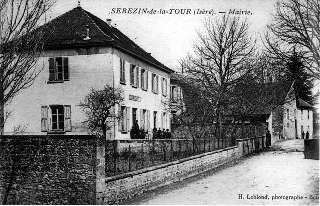

Серезен-де-ла-Тур
- коммуна во Франции
Hiking in Серезен-де-ла-Тур
Sérézin-de-la-Tour, nestled in the Auvergne-Rhône-Alpes region of France, offers charming hiking opportunities that attract both locals and visitors. The area is characterized by beautiful natural landscapes, including rolling hills, forests, and scenic views of the surrounding countryside....
- Страна:
- Почтовый код: 38300
- Координаты: 45° 33' 27" N, 5° 20' 39" E
- GPS треки (wikiloc): [Ссылка]
- Площадь: 9.31 кв.км
- Население: 1011
- Веб сайт: [Ссылка]


Сент-Аньен-сюр-Бьон
- коммуна во Франции
Hiking in Сент-Аньен-сюр-Бьон
Saint-Agnin-sur-Bion is a small commune located in the Auvergne-Rhône-Alpes region of France, known for its beautiful natural landscapes and opportunities for outdoor activities, including hiking....
- Страна:
- Почтовый код: 38300
- Координаты: 45° 32' 26" N, 5° 14' 39" E
- GPS треки (wikiloc): [Ссылка]
- Площадь: 9.7 кв.км
- Население: 993
- Веб сайт: [Ссылка]


Ниволас-Вермель
- коммуна во Франции
Hiking in Ниволас-Вермель
Nivolas-Vermelle is a charming commune located in the Auvergne-Rhône-Alpes region of southeastern France. While it may not be as widely known for hiking as some other regions in the Alps, it still offers beautiful natural surroundings and various outdoor activities....
- Страна:
- Почтовый код: 38300
- Координаты: 45° 33' 24" N, 5° 18' 23" E
- GPS треки (wikiloc): [Ссылка]
- Площадь: 6.09 кв.км
- Население: 2536
- Веб сайт: [Ссылка]


Мерье
- коммуна во Франции
Hiking in Мерье
Meyrié is a lesser-known gem for hikers, often appreciated for its natural beauty and tranquility. Located in the French Alps, it offers a range of hiking trails suitable for different skill levels, from leisurely strolls to more challenging treks....
- Страна:
- Почтовый код: 38300
- Координаты: 45° 33' 34" N, 5° 17' 14" E
- GPS треки (wikiloc): [Ссылка]
- Площадь: 3.43 кв.км
- Население: 1022
- Веб сайт: [Ссылка]


Шатовьен
- коммуна во Франции
Hiking in Шатовьен
Châteauvilain, located in the beautiful region of France, is known for its picturesque landscapes and hiking opportunities. While specific trails and conditions may vary, here are some general insights into hiking in the area:...
- Страна:
- Почтовый код: 38300
- Координаты: 45° 31' 0" N, 5° 19' 48" E
- GPS треки (wikiloc): [Ссылка]
- Высота над уровнем моря: 500 м m
- Площадь: 8.82 кв.км
- Население: 701
- Веб сайт: [Ссылка]

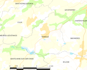
Трамоле
- коммуна во Франции
Hiking in Трамоле
Tramolé, located in the Italian region of Emilia-Romagna, is a fantastic destination for hiking enthusiasts, especially those looking for beautiful landscapes, tranquility, and a mix of nature and history. Although Tramolé itself is a small mountain area, it's surrounded by the larger Apennine range, offering numerous trails and opportunities for exploration....
- Страна:
- Почтовый код: 38300
- Координаты: 45° 31' 8" N, 5° 16' 4" E
- GPS треки (wikiloc): [Ссылка]
- Площадь: 6.99 кв.км
- Население: 673
- Веб сайт: [Ссылка]
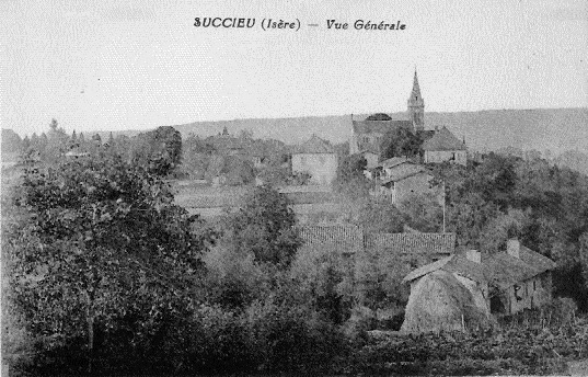
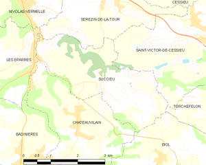
Сюксьё
- коммуна во Франции
Hiking in Сюксьё
Succieu is a charming village located in the Auvergne-Rhône-Alpes region of France, surrounded by beautiful landscapes that make it an appealing destination for hiking enthusiasts. While it may not be as well-known as some larger hiking areas, it offers a variety of trails that showcase the natural beauty of the region....
- Страна:
- Почтовый код: 38300
- Координаты: 45° 31' 40" N, 5° 20' 20" E
- GPS треки (wikiloc): [Ссылка]
- Площадь: 8.35 кв.км
- Население: 728
- Веб сайт: [Ссылка]