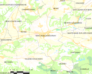
canton of Saint-Jean-de-Bournay (canton de Saint-Jean-de-Bournay)
 Hiking in canton of Saint-Jean-de-Bournay
Canton de Saint-Jean-de-Bournay is a picturesque region located in the Isère department of southeastern France, offering a variety of hiking opportunities that cater to both casual walkers and more experienced hikers. The area is characterized by its rural landscapes, rolling hills, and scenic countryside, providing a serene backdrop for outdoor adventures.
Key Hiking Features in Canton de Saint-Jean-de-Bournay:
-
Diverse Trails: The canton offers a network of marked hiking trails, ranging from easy strolls to more challenging routes. Trails often meander through forests, pastures, and along rivers, providing a close-up view of the local flora and fauna.
-
Heritage and Culture: Hikes in this area can often include visits to historic sites, charming villages, and traditional farms. Stopping by local markets or tasting regional delicacies can enhance your hiking experience.
-
Natural Beauty: The surrounding landscape boasts beautiful views of the Grésivaudan valley and the Chartreuse mountain range. The changing seasons also add to the visual appeal, making it a year-round destination.
-
Nearby Natural Parks: The proximity to larger natural parks and protected areas offers additional opportunities for hiking, including more rugged terrains and higher elevations for those seeking adventure.
-
Guided Tours: For those unfamiliar with the area, guided hiking tours may be available, providing insight into the local ecosystem, history, and culture.
Tips for Hiking in Canton de Saint-Jean-de-Bournay:
- Plan Ahead: Check trail maps and local resources for current conditions and difficulty levels.
- Be Prepared: Bring appropriate clothing, plenty of water, snacks, and a fully charged phone or GPS, as certain trails may be remote.
- Respect Nature: Follow Leave No Trace principles to help preserve the beauty of the area.
- Seasonal Considerations: Be aware of the seasons, as winter may present snow-covered trails, while spring and summer are perfect for wildflower sightings.
Overall, hiking in Canton de Saint-Jean-de-Bournay is an excellent way to enjoy the natural beauty, cultural heritage, and tranquility of the French countryside. Whether you’re looking for a casual day's hike or an invigorating trek, you’ll find something that suits your pace and interests.
- Страна:

- Столица: Сен-Жан-де-Бурне
- Координаты: 45° 30' 9" N, 5° 10' 22" E


- GPS треки (wikiloc): [Ссылка]
- Хранилище Wikidata: Wikidata: Q1727206
- код кантона INSEE: [3828]
Включает регионы:

Сен-Жан-де-Бурне
- коммуна во Франции
Hiking in Сен-Жан-де-Бурне
Saint-Jean-de-Bournay is a charming commune located in the Isère department of the Auvergne-Rhône-Alpes region in southeastern France. The surrounding area is characterized by diverse landscapes, including low valleys, rolling hills, and scenic views, making it a great destination for hiking enthusiasts....
- Страна:
- Почтовый код: 38440
- Координаты: 45° 30' 8" N, 5° 8' 16" E
- GPS треки (wikiloc): [Ссылка]
- Площадь: 26.87 кв.км
- Население: 4622
- Веб сайт: [Ссылка]


Кюлен
- коммуна во Франции
Hiking in Кюлен
Culin may not be widely recognized as a significant hiking destination, as there are numerous regions and trails around the world. Could you provide a bit more context or specify which Culin you're referring to? For instance, it could refer to a specific location or a local feature. If you're looking for general information on hiking tips, trail recommendations, or safety precautions, I would be happy to provide that!...
- Страна:
- Почтовый код: 38300
- Координаты: 45° 31' 27" N, 5° 15' 9" E
- GPS треки (wikiloc): [Ссылка]
- Площадь: 7.32 кв.км
- Население: 733
- Веб сайт: [Ссылка]


Вильнев-де-Марк
- коммуна во Франции
Hiking in Вильнев-де-Марк
Villeneuve-de-Marc is a charming village located in the Auvergne-Rhône-Alpes region of France. It's situated near the Rhône River and offers a picturesque landscape that is perfect for hiking enthusiasts. Here are some details to help you plan a hiking trip in and around Villeneuve-de-Marc:...
- Страна:
- Почтовый код: 38440
- Координаты: 45° 28' 33" N, 5° 6' 8" E
- GPS треки (wikiloc): [Ссылка]
- Площадь: 26.18 кв.км
- Население: 1140
- Веб сайт: [Ссылка]


Сава-Мепен
- коммуна во Франции
Hiking in Сава-Мепен
Savas-Mépin is a small commune located in the Auvergne-Rhône-Alpes region of southeastern France, known for its scenic natural landscapes and outdoor activities, including hiking. While being less well-known than some major hiking destinations in the Alps or the Vercors region, Savas-Mépin offers a peaceful environment for outdoor enthusiasts....
- Страна:
- Почтовый код: 38440
- Координаты: 45° 29' 22" N, 5° 4' 16" E
- GPS треки (wikiloc): [Ссылка]
- Площадь: 10.43 кв.км
- Население: 869
- Веб сайт: [Ссылка]


Сент-Аньен-сюр-Бьон
- коммуна во Франции
Hiking in Сент-Аньен-сюр-Бьон
Saint-Agnin-sur-Bion is a small commune located in the Auvergne-Rhône-Alpes region of France, known for its beautiful natural landscapes and opportunities for outdoor activities, including hiking....
- Страна:
- Почтовый код: 38300
- Координаты: 45° 32' 26" N, 5° 14' 39" E
- GPS треки (wikiloc): [Ссылка]
- Площадь: 9.7 кв.км
- Население: 993
- Веб сайт: [Ссылка]


Сент-Анн-сюр-Жервонд
- коммуна во Франции
Hiking in Сент-Анн-сюр-Жервонд
Sainte-Anne-sur-Gervonde, a picturesque municipality located in the Laurentian region of Quebec, Canada, offers several opportunities for hiking enthusiasts to explore its natural beauty. While there may not be established, well-known trails like those in larger parks, the area is characterized by its beautiful landscapes, forests, and lakes that can provide a range of outdoor experiences....
- Страна:
- Почтовый код: 38440
- Координаты: 45° 29' 59" N, 5° 14' 0" E
- GPS треки (wikiloc): [Ссылка]
- Площадь: 7.67 кв.км
- Население: 649
- Веб сайт: [Ссылка]
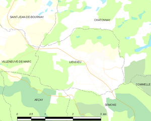
Льёдьё
- коммуна во Франции
Hiking in Льёдьё
Lieudieu is a scenic area located in the Auvergne-Rhône-Alpes region of France, nestled in the beautiful landscapes of the Alps. Hiking in this region can offer breathtaking views, diverse terrain, and opportunities to explore both nature and local culture....
- Страна:
- Почтовый код: 38440
- Координаты: 45° 27' 30" N, 5° 10' 53" E
- GPS треки (wikiloc): [Ссылка]
- Площадь: 5.94 кв.км
- Население: 341

Эклоз
- коммуна во Франции
Hiking in Эклоз
Eclose is a lesser-known hiking destination, but it generally offers beautiful landscapes and outdoor opportunities. However, because there may be a mix-up or lack of detailed information about a place called "Eclose," it's essential to clarify the specific region you are referring to, as there might be multiple locations by that name worldwide....
- Страна:
- Почтовый код: 38300
- Координаты: 45° 29' 58" N, 5° 18' 0" E
- GPS треки (wikiloc): [Ссылка]


Мейсье
- коммуна во Франции
Hiking in Мейсье
Meyssiez is a small town located in the Auvergne-Rhône-Alpes region of France, surrounded by beautiful natural landscapes that make it a great spot for hiking enthusiasts. Here are some details about hiking in and around Meyssiez:...
- Страна:
- Почтовый код: 38440
- Координаты: 45° 28' 13" N, 5° 3' 15" E
- GPS треки (wikiloc): [Ссылка]
- Площадь: 13.88 кв.км
- Население: 619

Артас
- коммуна во Франции
Hiking in Артас
Artas, located in the Isère department of the Auvergne-Rhône-Alpes region in southeastern France, is known for its beautiful landscapes and diverse hiking opportunities. Though small, the area surrounding Artas features a variety of trails that cater to different levels of hikers, from beginners to more experienced mountain trekkers....
- Страна:
- Почтовый код: 38440
- Координаты: 45° 32' 7" N, 5° 9' 52" E
- GPS треки (wikiloc): [Ссылка]
- Площадь: 14.15 кв.км
- Население: 1817
- Веб сайт: [Ссылка]


Шатонне
- коммуна во Франции
Hiking in Шатонне
Châtonnay is a charming village located in the Isère department of the Auvergne-Rhône-Alpes region in France, offering beautiful landscapes and a variety of hiking opportunities. While it may not be as well-known as some of the larger national parks or hiking destinations in France, the surrounding areas feature picturesque scenery, including rolling hills, forests, and valleys....
- Страна:
- Почтовый код: 38440
- Координаты: 45° 29' 9" N, 5° 12' 25" E
- GPS треки (wikiloc): [Ссылка]
- Площадь: 31.84 кв.км
- Население: 2070
- Веб сайт: [Ссылка]

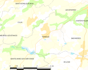
Трамоле
- коммуна во Франции
Hiking in Трамоле
Tramolé, located in the Italian region of Emilia-Romagna, is a fantastic destination for hiking enthusiasts, especially those looking for beautiful landscapes, tranquility, and a mix of nature and history. Although Tramolé itself is a small mountain area, it's surrounded by the larger Apennine range, offering numerous trails and opportunities for exploration....
- Страна:
- Почтовый код: 38300
- Координаты: 45° 31' 8" N, 5° 16' 4" E
- GPS треки (wikiloc): [Ссылка]
- Площадь: 6.99 кв.км
- Население: 673
- Веб сайт: [Ссылка]

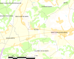
Руая
- коммуна во Франции
Hiking in Руая
Royas is a beautiful yet lesser-known hiking destination, perfect for those looking to explore nature away from the more crowded trails. Although it might not be as famous as other hiking spots, it offers stunning landscapes, diverse wildlife, and a peaceful atmosphere....
- Страна:
- Почтовый код: 38440
- Координаты: 45° 30' 21" N, 5° 6' 16" E
- GPS треки (wikiloc): [Ссылка]
- Площадь: 5.48 кв.км
- Население: 389
- Веб сайт: [Ссылка]


Бовуар-де-Марк
- коммуна во Франции
Hiking in Бовуар-де-Марк
Beauvoir-de-Marc is a charming commune located in the Isère department of the Auvergne-Rhône-Alpes region in southeastern France. While it may not be as widely recognized as some other hiking destinations, it offers a variety of scenic trails and outdoor activities that can be enjoyed by hikers of all levels....
- Страна:
- Почтовый код: 38440
- Координаты: 45° 31' 7" N, 5° 4' 45" E
- GPS треки (wikiloc): [Ссылка]
- Площадь: 11.27 кв.км
- Население: 1140
- Веб сайт: [Ссылка]

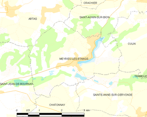
Мерье-лез-Этан
- коммуна во Франции
Hiking in Мерье-лез-Этан
Meyrieu-les-Étangs is a charming commune located in the Auvergne-Rhône-Alpes region of France. Nestled in a rural setting, it offers several opportunities for hiking enthusiasts to enjoy nature and exploration....
- Страна:
- Почтовый код: 38440
- Координаты: 45° 30' 49" N, 5° 12' 0" E
- GPS треки (wikiloc): [Ссылка]
- Высота над уровнем моря: 390 м m
- Площадь: 8.54 кв.км
- Население: 969
- Веб сайт: [Ссылка]