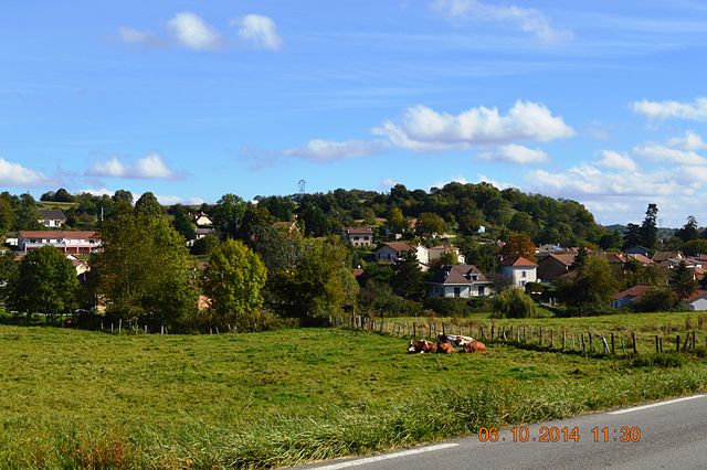
Мерье-лез-Этан (Meyrieu-les-Étangs, Meyrieu-les-Étangs)

- коммуна во Франции
 Hiking in Мерье-лез-Этан
Meyrieu-les-Étangs is a charming commune located in the Auvergne-Rhône-Alpes region of France. Nestled in a rural setting, it offers several opportunities for hiking enthusiasts to enjoy nature and exploration.
Hiking Opportunities
-
Scenic Trails: The area features various trails that meander through beautiful landscapes, including forests, meadows, and water bodies. The terrain is generally varied, providing options for both beginners and more experienced hikers.
-
Local Nature Reserves: There may be nearby nature reserves worth exploring, which can offer guided trails and educational information about local flora and fauna.
-
Wildlife Viewing: The region is home to diverse wildlife, making it an excellent location for birdwatching and observing other animals in their natural habitat.
-
Cultural Routes: Some trails may also take you through historical sites, giving you a taste of local culture and heritage while you hike.
Preparation Tips
-
Maps and Guides: Before heading out, it’s wise to acquire a detailed map of the hiking trails or contact local tourist information for recommended routes.
-
Gear: Wear appropriate hiking gear, including sturdy footwear and layered clothing, as weather conditions can change.
-
Safety: Carry adequate water, snacks, and a first-aid kit. Make sure someone knows your planned route and estimated return time.
-
Seasonal Considerations: Depending on the season, trails may vary in accessibility due to weather conditions, so check local advice.
Additional Activities
Besides hiking, visitors may find opportunities for cycling, fishing, or simply enjoying picnics in the picturesque surroundings.
Conclusion
Meyrieu-les-Étangs serves as a peaceful escape for hikers and nature lovers. Whether you’re looking for a short walk or an extended hike, this area provides a serene backdrop to enjoy the outdoors. Always check local resources for up-to-date trail information and safety guidelines before embarking on your adventure.
- Страна:

- Почтовый код: 38440
- Координаты: 45° 30' 49" N, 5° 12' 0" E


- GPS треки (wikiloc): [Ссылка]
- Высота над уровнем моря: 390 м m
- Площадь: 8.54 кв.км
- Население: 969
- Веб сайт: http://www.meyrieulesetangs.fr
- Википедия русская: wiki(ru)
- Википедия английская: wiki(en)
- Википедия национальная: wiki(fr)
- Хранилище Wikidata: Wikidata: Q966103
- Катеория в википедии: [Ссылка]
- код Freebase: [/m/03nvgm9]
- номер SIREN: [213802317]
- код BNF: [152580454]
- код VIAF: Альт: [139681393]
- код муниципалитета INSEE: 38231
Граничит с регионами:

Сен-Жан-де-Бурне
- коммуна во Франции
Hiking in Сен-Жан-де-Бурне
Saint-Jean-de-Bournay is a charming commune located in the Isère department of the Auvergne-Rhône-Alpes region in southeastern France. The surrounding area is characterized by diverse landscapes, including low valleys, rolling hills, and scenic views, making it a great destination for hiking enthusiasts....
- Страна:
- Почтовый код: 38440
- Координаты: 45° 30' 8" N, 5° 8' 16" E
- GPS треки (wikiloc): [Ссылка]
- Площадь: 26.87 кв.км
- Население: 4622
- Веб сайт: [Ссылка]


Кюлен
- коммуна во Франции
Hiking in Кюлен
Culin may not be widely recognized as a significant hiking destination, as there are numerous regions and trails around the world. Could you provide a bit more context or specify which Culin you're referring to? For instance, it could refer to a specific location or a local feature. If you're looking for general information on hiking tips, trail recommendations, or safety precautions, I would be happy to provide that!...
- Страна:
- Почтовый код: 38300
- Координаты: 45° 31' 27" N, 5° 15' 9" E
- GPS треки (wikiloc): [Ссылка]
- Площадь: 7.32 кв.км
- Население: 733
- Веб сайт: [Ссылка]


Сент-Аньен-сюр-Бьон
- коммуна во Франции
Hiking in Сент-Аньен-сюр-Бьон
Saint-Agnin-sur-Bion is a small commune located in the Auvergne-Rhône-Alpes region of France, known for its beautiful natural landscapes and opportunities for outdoor activities, including hiking....
- Страна:
- Почтовый код: 38300
- Координаты: 45° 32' 26" N, 5° 14' 39" E
- GPS треки (wikiloc): [Ссылка]
- Площадь: 9.7 кв.км
- Население: 993
- Веб сайт: [Ссылка]


Сент-Анн-сюр-Жервонд
- коммуна во Франции
Hiking in Сент-Анн-сюр-Жервонд
Sainte-Anne-sur-Gervonde, a picturesque municipality located in the Laurentian region of Quebec, Canada, offers several opportunities for hiking enthusiasts to explore its natural beauty. While there may not be established, well-known trails like those in larger parks, the area is characterized by its beautiful landscapes, forests, and lakes that can provide a range of outdoor experiences....
- Страна:
- Почтовый код: 38440
- Координаты: 45° 29' 59" N, 5° 14' 0" E
- GPS треки (wikiloc): [Ссылка]
- Площадь: 7.67 кв.км
- Население: 649
- Веб сайт: [Ссылка]

Артас
- коммуна во Франции
Hiking in Артас
Artas, located in the Isère department of the Auvergne-Rhône-Alpes region in southeastern France, is known for its beautiful landscapes and diverse hiking opportunities. Though small, the area surrounding Artas features a variety of trails that cater to different levels of hikers, from beginners to more experienced mountain trekkers....
- Страна:
- Почтовый код: 38440
- Координаты: 45° 32' 7" N, 5° 9' 52" E
- GPS треки (wikiloc): [Ссылка]
- Площадь: 14.15 кв.км
- Население: 1817
- Веб сайт: [Ссылка]


Шатонне
- коммуна во Франции
Hiking in Шатонне
Châtonnay is a charming village located in the Isère department of the Auvergne-Rhône-Alpes region in France, offering beautiful landscapes and a variety of hiking opportunities. While it may not be as well-known as some of the larger national parks or hiking destinations in France, the surrounding areas feature picturesque scenery, including rolling hills, forests, and valleys....
- Страна:
- Почтовый код: 38440
- Координаты: 45° 29' 9" N, 5° 12' 25" E
- GPS треки (wikiloc): [Ссылка]
- Площадь: 31.84 кв.км
- Население: 2070
- Веб сайт: [Ссылка]