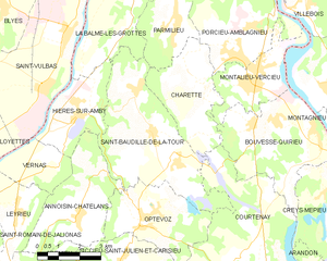
Оптевоз (Optevoz, Optevoz)

- коммуна во Франции
 Hiking in Оптевоз
Optevoz is a charming commune in the Isère department of the Auvergne-Rhône-Alpes region in southeastern France. While it may not be one of the most famous hiking destinations, it offers a beautiful backdrop for outdoor activities, including hiking, especially if you enjoy picturesque views and a more tranquil setting away from larger tourist crowds.
Hiking Opportunities in Optevoz
-
Scenic Trails: The area surrounding Optevoz features several trails that show off the stunning landscapes of the Rhône-Alpes region. Hikers can explore woodlands, meadows, and riverside paths.
-
Local Nature: Hiking here lets you enjoy diverse flora and fauna typical of the region. Keep an eye out for local wildlife and beautiful wildflowers in spring and summer.
-
Accessibility: Being a smaller commune, the trails might not be as well-marked as in more popular hiking areas, so it’s advisable to have a map or a reliable GPS app.
-
Nearby Trails: You can also easily access hiking routes in adjacent areas, including the Vercors Regional Natural Park and the Chartreuse Mountains, offering a wide range of hiking levels, from easy walks to more challenging mountain hikes.
-
Cultural Experience: As you hike, you may encounter charming villages, local artisan shops, and historical landmarks that provide a glimpse into the cultural heritage of the region.
Tips for Hiking in Optevoz
- Preparation: Before heading out, check local maps and guides and plan your route. Make sure to wear appropriate hiking shoes and bring necessary gear based on the season.
- Weather Check: The weather can change quickly, especially in mountainous areas, so check the forecast and dress in layers.
- Stay Hydrated and Snack Ready: Always carry sufficient water and snacks to stay energized during your hike.
Conclusion
Hiking in Optevoz can be a delightful experience for those looking for a peaceful escape in nature. The combination of beautiful landscapes, local culture, and tranquil atmosphere makes it a lovely destination for outdoor enthusiasts. Whether you're planning a short hike or a full-day adventure, don’t forget to take your time to soak in the beauty of the scenery!
- Страна:

- Почтовый код: 38460
- Координаты: 45° 45' 9" N, 5° 19' 53" E


- GPS треки (wikiloc): [Ссылка]
- Площадь: 12 кв.км
- Население: 829
- Веб сайт: http://www.optevoz.fr
- Википедия русская: wiki(ru)
- Википедия английская: wiki(en)
- Википедия национальная: wiki(fr)
- Хранилище Wikidata: Wikidata: Q629559
- Катеория в википедии: [Ссылка]
- код Freebase: [/m/03nvgqd]
- код GeoNames: Альт: [6433268]
- номер SIREN: [213802820]
- код BNF: [15258094b]
- код муниципалитета INSEE: 38282
Граничит с регионами:


Куртене
- коммуна во Франции
Hiking in Куртене
Courtenay, located in the Isère department of France, is surrounded by beautiful mountainous landscapes, making it a great destination for hiking enthusiasts. Here are some highlights and considerations for hiking in the area:...
- Страна:
- Почтовый код: 38510
- Координаты: 45° 43' 45" N, 5° 22' 45" E
- GPS треки (wikiloc): [Ссылка]
- Площадь: 32.08 кв.км
- Население: 1276
- Веб сайт: [Ссылка]


Аннуазен-Шатлан
- коммуна во Франции
Hiking in Аннуазен-Шатлан
Annoisin-Chatelans, located in the Isère department of the Auvergne-Rhône-Alpes region in southeastern France, offers a variety of hiking opportunities for all skill levels. Nestled near the foothills of the French Alps, this area features beautiful landscapes, lush greenery, and scenic views....
- Страна:
- Почтовый код: 38460
- Координаты: 45° 45' 25" N, 5° 17' 36" E
- GPS треки (wikiloc): [Ссылка]
- Площадь: 13.27 кв.км
- Население: 666

Сен-Бодий-де-ла-Тур
- коммуна во Франции
Hiking in Сен-Бодий-де-ла-Тур
Saint-Baudille-de-la-Tour is a charming commune located in the Isère department in the Auvergne-Rhône-Alpes region of southeastern France. It serves as an excellent starting point for outdoor activities, including hiking, thanks to its scenic landscapes and proximity to the Alps....
- Страна:
- Почтовый код: 38118
- Координаты: 45° 47' 23" N, 5° 20' 18" E
- GPS треки (wikiloc): [Ссылка]
- Площадь: 21.76 кв.км
- Население: 797
- Веб сайт: [Ссылка]


Сиксьё-Сен-Жюльен-э-Каризьё
- коммуна во Франции
Hiking in Сиксьё-Сен-Жюльен-э-Каризьё
Siccieu-Saint-Julien-et-Carisieu is a picturesque commune located in the Isère department of the Auvergne-Rhône-Alpes region in southeastern France. It is surrounded by beautiful landscapes that offer excellent hiking opportunities. Here are some insights into hiking in this region:...
- Страна:
- Почтовый код: 38460
- Координаты: 45° 44' 6" N, 5° 18' 58" E
- GPS треки (wikiloc): [Ссылка]
- Высота над уровнем моря: 335 м m
- Площадь: 14.22 кв.км
- Население: 600