Сент-Аньен-сюр-Бьон (Saint-Agnin-sur-Bion, Saint-Agnin-sur-Bion)

- коммуна во Франции
 Hiking in Сент-Аньен-сюр-Бьон
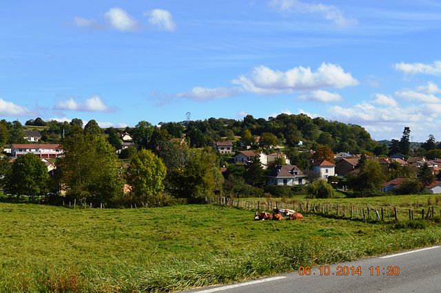
Saint-Agnin-sur-Bion is a small commune located in the Auvergne-Rhône-Alpes region of France, known for its beautiful natural landscapes and opportunities for outdoor activities, including hiking.
Hiking Trails: While the village itself may not have an extensive network of dedicated hiking trails, the surrounding region offers plenty of options for hikers of varying skill levels. Here are some tips and highlights for hiking in the area:
-
Natural Beauty: The region is characterized by rolling hills, lush forests, and scenic views that can be enjoyed from several vantage points along the trails.
-
Local Trails: Explore smaller local paths that may not be widely advertised. These can lead you through picturesque countryside, charming villages, and along the Bion River.
-
Nearby Parks and Reserves: Consider venturing slightly further afield to nearby natural parks such as the Parc naturel régional du Pilat. This park features a variety of trails, from easy walks to more challenging hikes, along with rich biodiversity.
-
Preparation: Always check local maps and guides to find the best routes. Make sure to wear appropriate footwear, carry enough water, and be aware of the changing weather conditions.
-
Wildlife and Flora: Keep an eye out for the local flora and fauna, as the region is home to diverse plant species and wildlife. Spring and summer are particularly vibrant times to see wildflowers.
-
Cultural Insights: Hiking in and around Saint-Agnin-sur-Bion can also be an opportunity to learn about the local culture and history, with small villages, old churches, and traditional farms often found along the trails.
-
Safety Tips: Always inform someone of your hiking plans and expected return time, especially if you are heading into less populated areas.
For the best experience, consider visiting local tourism websites or connecting with local hiking groups to get current information about trails, conditions, and perhaps guided hikes!
- Страна:

- Почтовый код: 38300
- Координаты: 45° 32' 26" N, 5° 14' 39" E


- GPS треки (wikiloc): [Ссылка]
- Площадь: 9.7 кв.км
- Население: 993
- Веб сайт: http://www.saintagninsurbion.fr
- Википедия русская: wiki(ru)
- Википедия английская: wiki(en)
- Википедия национальная: wiki(fr)
- Хранилище Wikidata: Wikidata: Q1067968
- Катеория в википедии: [Ссылка]
- код Freebase: [/m/03nvj21]
- код GeoNames: Альт: [6433315]
- номер SIREN: [213803513]
- код BNF: [152581620]
- код муниципалитета INSEE: 38351
Граничит с регионами:


Кюлен
- коммуна во Франции
Hiking in Кюлен
Culin may not be widely recognized as a significant hiking destination, as there are numerous regions and trails around the world. Could you provide a bit more context or specify which Culin you're referring to? For instance, it could refer to a specific location or a local feature. If you're looking for general information on hiking tips, trail recommendations, or safety precautions, I would be happy to provide that!...
- Страна:
- Почтовый код: 38300
- Координаты: 45° 31' 27" N, 5° 15' 9" E
- GPS треки (wikiloc): [Ссылка]
- Площадь: 7.32 кв.км
- Население: 733
- Веб сайт: [Ссылка]

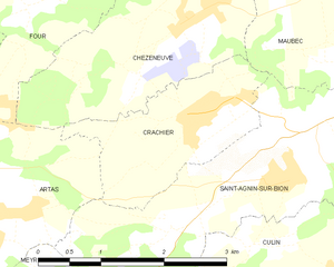
Крашье
- коммуна во Франции
Hiking in Крашье
Crachier, though not widely known, may refer to hiking areas in regions with picturesque landscapes and trails. If you're interested in a specific location with that name or similar sounding places, I could help you explore general hiking tips and information about various renowned hiking spots....
- Страна:
- Почтовый код: 38300
- Координаты: 45° 32' 54" N, 5° 13' 32" E
- GPS треки (wikiloc): [Ссылка]
- Площадь: 3.64 кв.км
- Население: 494


Мобек
- коммуна во Франции
Hiking in Мобек
Maubec, a small commune in the department of Isère in the Auvergne-Rhône-Alpes region of France, offers a charming backdrop for hiking enthusiasts. Nestled in the picturesque French Alps, it provides access to a variety of trails suitable for different skill levels, ranging from easy walks to more challenging hikes....
- Страна:
- Почтовый код: 38300
- Координаты: 45° 34' 6" N, 5° 15' 57" E
- GPS треки (wikiloc): [Ссылка]
- Площадь: 8.57 кв.км
- Население: 1704
- Веб сайт: [Ссылка]


Лез-Эпарр
- коммуна во Франции
Hiking in Лез-Эпарр
Les Éparres, located in the southeastern region of France near the Vercors Massif, offers beautiful landscapes and a variety of hiking trails suitable for different skill levels. The area is characterized by its stunning views, diverse flora and fauna, and the unique geological features of the region....
- Страна:
- Почтовый код: 38300
- Координаты: 45° 32' 1" N, 5° 17' 34" E
- GPS треки (wikiloc): [Ссылка]
- Площадь: 7.95 кв.км
- Население: 987


Мерье
- коммуна во Франции
Hiking in Мерье
Meyrié is a lesser-known gem for hikers, often appreciated for its natural beauty and tranquility. Located in the French Alps, it offers a range of hiking trails suitable for different skill levels, from leisurely strolls to more challenging treks....
- Страна:
- Почтовый код: 38300
- Координаты: 45° 33' 34" N, 5° 17' 14" E
- GPS треки (wikiloc): [Ссылка]
- Площадь: 3.43 кв.км
- Население: 1022
- Веб сайт: [Ссылка]

Артас
- коммуна во Франции
Hiking in Артас
Artas, located in the Isère department of the Auvergne-Rhône-Alpes region in southeastern France, is known for its beautiful landscapes and diverse hiking opportunities. Though small, the area surrounding Artas features a variety of trails that cater to different levels of hikers, from beginners to more experienced mountain trekkers....
- Страна:
- Почтовый код: 38440
- Координаты: 45° 32' 7" N, 5° 9' 52" E
- GPS треки (wikiloc): [Ссылка]
- Площадь: 14.15 кв.км
- Население: 1817
- Веб сайт: [Ссылка]

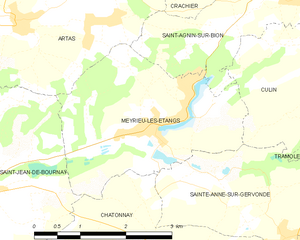
Мерье-лез-Этан
- коммуна во Франции
Hiking in Мерье-лез-Этан
Meyrieu-les-Étangs is a charming commune located in the Auvergne-Rhône-Alpes region of France. Nestled in a rural setting, it offers several opportunities for hiking enthusiasts to enjoy nature and exploration....
- Страна:
- Почтовый код: 38440
- Координаты: 45° 30' 49" N, 5° 12' 0" E
- GPS треки (wikiloc): [Ссылка]
- Высота над уровнем моря: 390 м m
- Площадь: 8.54 кв.км
- Население: 969
- Веб сайт: [Ссылка]