.jpg)
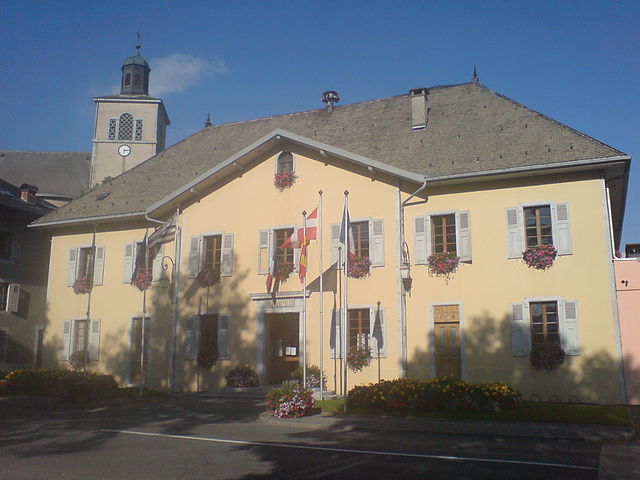
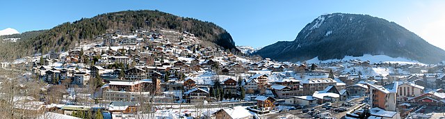
Ле-Же (Les Gets, Les Gets)

- коммуна во Франции
 Hiking in Ле-Же
Les Gets is a charming mountain resort located in the French Alps, part of the Portes du Soleil ski area. While it's well-known for its winter sports, it also offers fantastic hiking opportunities throughout the summer months. Here are some key details about hiking in Les Gets:
Scenic Trails
-
Diverse Terrain: The region features a variety of trails that cater to all skill levels, from easy walks suitable for families to challenging treks for experienced hikers. The terrain includes forests, alpine meadows, and stunning mountain vistas.
-
Marked Trails: The hiking paths are well-marked and maintained, with clear signage indicating the difficulty level and estimated hiking times.
-
Panoramic Views: Many trails offer breathtaking views of the surrounding mountains, including the Mont Blanc massif and the Dents du Midi. Sunrise and sunset hikes are particularly popular for capturing stunning vistas.
Popular Hikes
-
Les Gets to Mont Chéry: A moderate hike that can be completed in a few hours, offering great panoramic views from the summit.
-
Circuit des Folliets: This trail provides an immersive experience through local flora and fauna, with opportunities to spot wildlife along the way.
-
Liaison to Morzine: For those looking for a longer adventure, there are trails connecting Les Gets to nearby resorts like Morzine, offering a full day of hiking and exploration.
Family-Friendly Options
-
Short Walks: Several easy trails are suitable for families, often leading to picturesque spots for picnics or play areas for children.
-
The Les Gets Adventure Park: A great option for families looking to combine hiking with some fun activities like zip-lining and ropes courses.
Practical Tips
-
Best Time to Hike: Late spring to early autumn (May to September) is the ideal time for hiking. During this period, the weather is generally mild, and the trails are accessible.
-
Gear: Proper hiking gear is essential. Wear sturdy hiking boots, sunscreen, and bring plenty of water. A trekking pole can also be beneficial, especially on steep descents.
-
Local Guidance: Consider joining guided hikes organized by local tour companies to gain insights into the region’s natural and cultural history.
-
Maps and Apps: Take advantage of hiking maps available at local tourist offices or consider downloading hiking apps with offline maps for convenience.
Conclusion
Hiking in Les Gets provides an excellent opportunity to explore the stunning natural beauty of the French Alps while enjoying diverse trails that suit all levels. Whether you're looking for a day hike with breathtaking views or a leisurely stroll through serene alpine landscapes, Les Gets has something to offer every outdoor enthusiast.
- Страна:

- Почтовый код: 74260
- Координаты: 46° 9' 35" N, 6° 40' 13" E


- GPS треки (wikiloc): [Ссылка]
- Высота над уровнем моря: 1172 м m
- Площадь: 29.98 кв.км
- Население: 1251
- Веб сайт: http://www.lesgets.com
- Википедия английская: wiki(en)
- Википедия национальная: wiki(fr)
- Хранилище Wikidata: Wikidata: Q845832
- Катеория в википедии: [Ссылка]
- код Freebase: [/m/073_m4]
- код GeoNames: Альт: [3000902]
- номер SIREN: [217401348]
- код BNF: [15274392x]
- код VIAF: Альт: [235569048]
- код GND: Альт: [4235932-6]
- код муниципалитета INSEE: 74134
Граничит с регионами:

Taninges
- коммуна во Франции
Hiking in Taninges
Taninges, located in the Haute-Savoie region of the French Alps, is an excellent destination for hiking enthusiasts. The area is known for its breathtaking landscapes, including majestic mountains, lush valleys, and beautiful alpine meadows. Here are some highlights and tips for hiking in and around Taninges:...
- Страна:
- Почтовый код: 74440
- Координаты: 46° 6' 27" N, 6° 35' 29" E
- GPS треки (wikiloc): [Ссылка]
- Площадь: 42.66 кв.км
- Население: 3410

Morzine
- коммуна во Франции
Hiking in Morzine
Morzine is a beautiful alpine town located in the French Alps, part of the Portes du Soleil ski area, which is well-known for both winter sports and summer hiking opportunities. The region offers a diverse range of trails and breathtaking landscapes, making it ideal for hikers of all levels. Here’s what you need to know about hiking in Morzine:...
- Страна:
- Почтовый код: 74110
- Координаты: 46° 10' 48" N, 6° 42' 33" E
- GPS треки (wikiloc): [Ссылка]
- Высота над уровнем моря: 1000 м m
- Площадь: 44.1 кв.км
- Население: 2870
- Веб сайт: [Ссылка]


Verchaix
- коммуна во Франции
Hiking in Verchaix
Verchaix is a beautiful destination located in the French Alps, in the Haute-Savoie region. This picturesque village offers a range of hiking opportunities, making it an excellent choice for both casual hikers and experienced trekkers....
- Страна:
- Почтовый код: 74440
- Координаты: 46° 5' 47" N, 6° 40' 35" E
- GPS треки (wikiloc): [Ссылка]
- Площадь: 15.89 кв.км
- Население: 715


La Côte-d'Arbroz
- коммуна во Франции
Hiking in La Côte-d'Arbroz
La Côte-d'Arbroz is a charming commune located in the Haute-Savoie region of the French Alps. Known for its stunning landscapes and proximity to the Portes du Soleil ski area, it also offers fantastic hiking opportunities, particularly in the summer months when the snow melts and the meadows bloom....
- Страна:
- Почтовый код: 74110
- Координаты: 46° 11' 16" N, 6° 40' 5" E
- GPS треки (wikiloc): [Ссылка]
- Площадь: 12.24 кв.км
- Население: 323
- Веб сайт: [Ссылка]