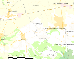
Марнан (Marnans, Marnans)

- коммуна во Франции
 Hiking in Марнан
Marnans, a picturesque area known for its stunning landscapes, offers a variety of hiking opportunities suitable for different skill levels. Whether you are a beginner or an experienced hiker, the region has something for everyone.
Popular Hiking Trails
-
The Marnans Ridge Trail: This trail is relatively moderate and features a mix of wooded areas and open vistas. It offers breathtaking views of the surrounding hills and valleys. It's great for families and those looking to enjoy a peaceful day in nature.
-
Valley Loop Trail: This is an easier trail perfect for beginners or those looking for a leisurely hike. It winds through beautiful flora and often provides opportunities to see local wildlife.
-
Summit Trail: For more experienced hikers, this challenging trail leads to the highest point in Marnans, offering panoramic views. Expect steeper inclines and rocky terrain, making it important to be prepared with adequate footwear and hydration.
Best Times to Hike
The ideal times for hiking in Marnans are typically in the spring and fall, when temperatures are mild, and you can enjoy vibrant wildflowers or stunning autumn foliage. Summer can be warm, while winter may see snow in higher elevations, affecting trail conditions.
Preparing for Your Hike
- Gear and Supplies: Always wear appropriate hiking shoes, carry a map or GPS device, and pack enough water and snacks.
- Weather Awareness: Check the weather forecast before heading out, and be prepared for changing conditions, especially at higher elevations.
- Safety: Inform someone about your hiking plans, and consider hiking with a buddy. It's also wise to carry a first-aid kit and a whistle.
Leave No Trace
Remember to respect the natural environment by following Leave No Trace principles. This includes staying on marked trails, disposing of waste properly, and avoiding picking plants or disturbing wildlife.
Overall, Marnans presents an excellent opportunity for outdoor enthusiasts to connect with nature and enjoy the physical challenge of hiking. Happy trails!
- Страна:

- Почтовый код: 38980
- Координаты: 45° 17' 41" N, 5° 14' 14" E


- GPS треки (wikiloc): [Ссылка]
- Площадь: 6.6 кв.км
- Население: 152
- Википедия русская: wiki(ru)
- Википедия английская: wiki(en)
- Википедия национальная: wiki(fr)
- Хранилище Wikidata: Wikidata: Q1069478
- Катеория в википедии: [Ссылка]
- код Freebase: [/m/03nvhxk]
- код GeoNames: Альт: [6433234]
- номер SIREN: [213802218]
- код BNF: [15258035t]
- код муниципалитета INSEE: 38221
Граничит с регионами:

Шатене
Hiking in Шатене
Châtenay is a charming commune located in the Isère department of the Auvergne-Rhône-Alpes region in southeastern France. While it may not be as well-known for hiking as some of the larger national parks or mountain ranges in the area, it offers several opportunities for outdoor activities, including hiking....
- Страна:
- Почтовый код: 38980
- Координаты: 45° 19' 14" N, 5° 13' 45" E
- GPS треки (wikiloc): [Ссылка]
- Площадь: 4.62 кв.км
- Население: 442

Сен-Симеон-де-Бресьё
- коммуна во Франции
Hiking in Сен-Симеон-де-Бресьё
Saint-Siméon-de-Bressieux is a charming village located in the Isère department in the Auvergne-Rhône-Alpes region of France. The surrounding area offers stunning natural landscapes, making it an excellent spot for hiking enthusiasts....
- Страна:
- Почтовый код: 38870
- Координаты: 45° 19' 42" N, 5° 15' 42" E
- GPS треки (wikiloc): [Ссылка]
- Площадь: 18.79 кв.км
- Население: 2876
- Веб сайт: [Ссылка]


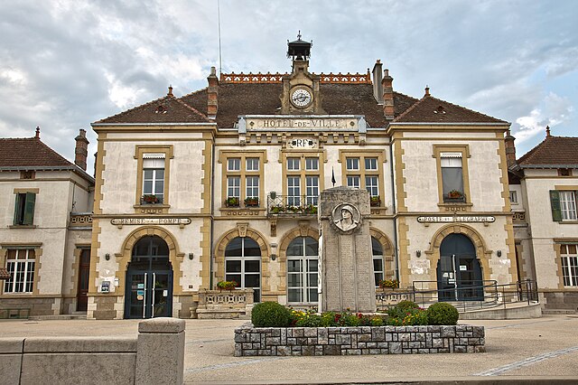
Сен-Пьер-де-Бресьё
- коммуна во Франции
Hiking in Сен-Пьер-де-Бресьё
Saint-Pierre-de-Bressieux is a charming commune located in the Isère department of France, nestled in the picturesque region of Auvergne-Rhône-Alpes. Hiking around this area offers beautiful landscapes, varying terrains, and opportunities to explore the local flora and fauna....
- Страна:
- Почтовый код: 38870
- Координаты: 45° 18' 56" N, 5° 17' 7" E
- GPS треки (wikiloc): [Ссылка]
- Площадь: 23.08 кв.км
- Население: 766
- Веб сайт: [Ссылка]


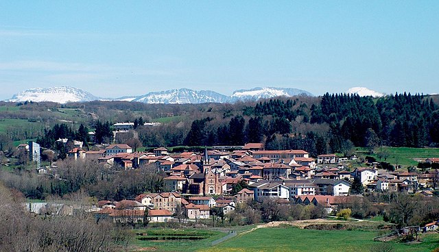
Виривиль
- коммуна во Франции
Hiking in Виривиль
Viriville is a charming village located in the Isère department of France, nestled in the breathtaking backdrop of the French Alps. Hiking in this region offers an incredible experience, with its stunning landscapes, diverse flora and fauna, and a variety of trails suitable for different skill levels....
- Страна:
- Почтовый код: 38980
- Координаты: 45° 18' 57" N, 5° 12' 15" E
- GPS треки (wikiloc): [Ссылка]
- Площадь: 30.46 кв.км
- Население: 1634
- Веб сайт: [Ссылка]

Руабон
- коммуна во Франции
Hiking in Руабон
Roybon, located in the Auvergne-Rhône-Alpes region of France, offers several hiking opportunities for outdoor enthusiasts. The area is characterized by its beautiful landscapes, ranging from forests to rolling hills, making it ideal for both novice and experienced hikers....
- Страна:
- Почтовый код: 38940
- Координаты: 45° 15' 31" N, 5° 14' 39" E
- GPS треки (wikiloc): [Ссылка]
- Площадь: 67.31 кв.км
- Население: 1229
- Веб сайт: [Ссылка]