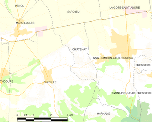
Сен-Симеон-де-Бресьё (Saint-Siméon-de-Bressieux, Saint-Siméon-de-Bressieux)

- коммуна во Франции
 Hiking in Сен-Симеон-де-Бресьё
Saint-Siméon-de-Bressieux is a charming village located in the Isère department in the Auvergne-Rhône-Alpes region of France. The surrounding area offers stunning natural landscapes, making it an excellent spot for hiking enthusiasts.
Hiking Opportunities:
-
Scenic Trails: The region features a variety of hiking trails that cater to different skill levels. Whether you're looking for easy walks or more challenging treks, you're likely to find a route that suits your needs.
-
Natural Landscapes: Hikers can enjoy picturesque views of rolling hills, forests, and nearby mountains. The diverse flora and fauna can make your hike even more enjoyable, with opportunities for birdwatching and observing local wildlife.
-
Cultural Experiences: Some trails may lead you through historical sites, vineyards, or quaint villages where you can experience local culture, cuisine, and traditions.
-
Map and Trail Information: It’s advisable to carry a reliable hiking map or use a hiking app to navigate the trails. Local tourist offices or hiking clubs can provide detailed information on trail conditions, difficulty levels, and safety tips.
-
Best Time to Hike: Spring and early fall are often the best times for hiking, as the weather is usually mild and the landscapes are vibrant.
-
Recommended Gear: Proper hiking footwear, weather-appropriate clothing, and essentials such as water, snacks, and a first aid kit are important for a safe and enjoyable experience.
If you plan on hiking in Saint-Siméon-de-Bressieux, whether alone or with a group, it’s always a good idea to check local regulations and adhere to any specific guidelines regarding trail access and conservation. Happy hiking!
- Страна:

- Почтовый код: 38870
- Координаты: 45° 19' 42" N, 5° 15' 42" E


- GPS треки (wikiloc): [Ссылка]
- Площадь: 18.79 кв.км
- Население: 2876
- Веб сайт: http://www.st-simeon-de-bressieux.fr
- Википедия русская: wiki(ru)
- Википедия английская: wiki(en)
- Википедия национальная: wiki(fr)
- Хранилище Wikidata: Wikidata: Q1067815
- Катеория в википедии: [Ссылка]
- код Freebase: [/m/03nvhh4]
- номер SIREN: [213804578]
- код BNF: [15258264z]
- код муниципалитета INSEE: 38457
Граничит с регионами:


Брезен
- коммуна во Франции
Hiking in Брезен
Brézins is a small commune located in the Isère department in the Auvergne-Rhône-Alpes region of southeastern France. While it may not be one of the most popular hiking destinations, it serves as a great starting point for exploring the surrounding natural beauty of the region, including the stunning landscapes of the Chartreuse and Vercors mountains....
- Страна:
- Почтовый код: 38590
- Координаты: 45° 20' 57" N, 5° 18' 24" E
- GPS треки (wikiloc): [Ссылка]
- Площадь: 8.26 кв.км
- Население: 2042
- Веб сайт: [Ссылка]

Шатене
Hiking in Шатене
Châtenay is a charming commune located in the Isère department of the Auvergne-Rhône-Alpes region in southeastern France. While it may not be as well-known for hiking as some of the larger national parks or mountain ranges in the area, it offers several opportunities for outdoor activities, including hiking....
- Страна:
- Почтовый код: 38980
- Координаты: 45° 19' 14" N, 5° 13' 45" E
- GPS треки (wikiloc): [Ссылка]
- Площадь: 4.62 кв.км
- Население: 442


Сен-Пьер-де-Бресьё
- коммуна во Франции
Hiking in Сен-Пьер-де-Бресьё
Saint-Pierre-de-Bressieux is a charming commune located in the Isère department of France, nestled in the picturesque region of Auvergne-Rhône-Alpes. Hiking around this area offers beautiful landscapes, varying terrains, and opportunities to explore the local flora and fauna....
- Страна:
- Почтовый код: 38870
- Координаты: 45° 18' 56" N, 5° 17' 7" E
- GPS треки (wikiloc): [Ссылка]
- Площадь: 23.08 кв.км
- Население: 766
- Веб сайт: [Ссылка]


Марнан
- коммуна во Франции
Hiking in Марнан
Marnans, a picturesque area known for its stunning landscapes, offers a variety of hiking opportunities suitable for different skill levels. Whether you are a beginner or an experienced hiker, the region has something for everyone....
- Страна:
- Почтовый код: 38980
- Координаты: 45° 17' 41" N, 5° 14' 14" E
- GPS треки (wikiloc): [Ссылка]
- Площадь: 6.6 кв.км
- Население: 152


Сардьё
- коммуна во Франции
Hiking in Сардьё
Sardieu is a beautiful destination for hiking, located in the Isère department of France, near the foothills of the Alps. This region is known for its scenic landscapes, diverse terrain, and beautiful views, making it a great spot for outdoor enthusiasts....
- Страна:
- Почтовый код: 38260
- Координаты: 45° 22' 9" N, 5° 12' 43" E
- GPS треки (wikiloc): [Ссылка]
- Высота над уровнем моря: 358 м m
- Площадь: 11.2 кв.км
- Население: 1097
- Веб сайт: [Ссылка]

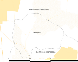
Бресьё
- коммуна во Франции
Hiking in Бресьё
Bressieux, located in the Isère department of the Auvergne-Rhône-Alpes region in France, offers a variety of hiking opportunities suitable for different skill levels and preferences. The region is known for its beautiful natural landscapes, which include rolling hills, forests, and views of the surrounding mountains....
- Страна:
- Почтовый код: 38870
- Координаты: 45° 19' 21" N, 5° 16' 36" E
- GPS треки (wikiloc): [Ссылка]
- Площадь: 0.89 кв.км
- Население: 88
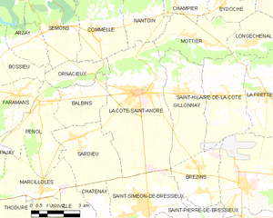
Ла-Кот-Сент-Андре
- коммуна во Франции
Hiking in Ла-Кот-Сент-Андре
La Côte-Saint-André is a charming commune located in the Isère department in the Auvergne-Rhône-Alpes region of southeastern France. It offers beautiful landscapes and a variety of hiking opportunities, making it a great destination for outdoor enthusiasts. Here are some highlights about hiking in and around La Côte-Saint-André:...
- Страна:
- Почтовый код: 38260
- Координаты: 45° 23' 37" N, 5° 15' 38" E
- GPS треки (wikiloc): [Ссылка]
- Площадь: 27.93 кв.км
- Население: 4745
- Веб сайт: [Ссылка]