Мисбах (Miesbach, Landkreis Miesbach)

- район Баварии
 Hiking in Мисбах
Miesbach is a scenic district located in Bavaria, Germany, known for its stunning landscapes, rolling hills, and proximity to the Alps. It offers a wealth of hiking opportunities for both beginners and experienced hikers. Here are some highlights about hiking in the Miesbach district:
Scenic Trails
-
Tegernsee Region: The area around Lake Tegernsee boasts numerous well-marked hiking trails. You can enjoy beautiful lakeside walks or ascend into the mountains for panoramic views of the lake and surrounding peaks.
-
Schliersee: The trails around Schliersee are equally stunning, offering a mix of moderate to challenging hikes. The area is known for its picturesque lake and surrounding mountains, including the famous Brecherspitz.
-
Mangfallgebirge Nature Park: This nature park offers a variety of trails, many of which traverse the beautiful alpine landscape, featuring lush forests, meadows, and views of rugged mountain terrain.
Notable Hikes
-
Wallberg: A popular hiking destination with a well-marked trail leading to the summit, offering breathtaking views of the Bavarian Alps and Lake Tegernsee. There's also a cable car for those who prefer a less strenuous ascent.
-
Brecherspitz: This hike provides an adventurous route with challenging sections but rewards hikers with spectacular views over Schliersee and the surrounding mountains.
-
Tegernsee to Gmund: A lovely trail that goes along the banks of Lake Tegernsee, perfect for a leisurely hike while taking in the beauty of the lake and the alpine backdrop.
Tips for Hiking in Miesbach
-
Season: Spring and autumn are ideal for hiking, as the weather is usually mild, and the landscapes are particularly beautiful. Summer can be busy with tourists, while winter offers opportunities for snowshoeing or winter hiking.
-
Equipment: Wear sturdy hiking boots, and depending on the season, dress in layers. A good backpack with essentials like water, snacks, and a first aid kit is recommended.
-
Navigation: Most trails in Miesbach are well-marked, but bringing a map or GPS can be helpful, especially for more remote hikes.
-
Local Resources: The Miesbach district is home to several visitor centers and local tourism offices that can provide information on current trail conditions, maps, and recommendations.
Safety Considerations
- Always inform someone of your hiking plans, especially when venturing into more remote areas.
- Be aware of weather conditions, as they can change rapidly in mountainous regions.
- Respect the natural environment and follow the Leave No Trace principles.
Whether you're looking for a leisurely lakeside stroll or a challenging mountain ascent, Miesbach has a wealth of hiking opportunities to explore and enjoy!
- Страна:

- Столица: Мисбах
- Код автомобильного номера: MB
- Координаты: 47° 44' 24" N, 11° 48' 36" E


- GPS треки (wikiloc): [Ссылка]
- Высота над уровнем моря: 741 м m
- Площадь: 864.00 кв.км
- Население: 93630
- Веб сайт: http://www.landkreis-miesbach.de/
- Википедия русская: wiki(ru)
- Википедия английская: wiki(en)
- Википедия национальная: wiki(de)
- Хранилище Wikidata: Wikidata: Q10523
- Галерея изображений в википедии: [Ссылка]
- Катеория в википедии: [Ссылка]
- Карты в википедии: [Ссылка]
- код Freebase: [/m/022hhh]
- код GeoNames: Альт: [3220835]
- код VIAF: Альт: [312812915]
- ID отношения в OpenStreetMap: [2168231]
- код GND: Альт: [4039158-9]
- идентификатор местоположения ArchINFORM: [2521]
- код LCNAF: Альт: [n84012899]
- код темы Quora: [Miesbach]
- код TGN: [7077295]
- код Historical Gazetteer: [adm_139182]
- Bavarikon ID: [ODB_A00002354]
- код NUTS: [DE21F]
- код района Германии: 09182
Включает регионы:

Иршенберг
Hiking in Иршенберг
Irschenberg is a picturesque town located in Bavaria, Germany, known for its scenic landscapes and proximity to the Alps. Hiking in Irschenberg offers a variety of trails suitable for different skill levels, making it an attractive destination for outdoor enthusiasts....
- Страна:
- Почтовый код: 83737
- Телефонный код: 08064; 08062; 08025; 08020
- Код автомобильного номера: MB
- Координаты: 47° 50' 0" N, 11° 55' 0" E
- GPS треки (wikiloc): [Ссылка]
- Высота над уровнем моря: 731 м m
- Площадь: 53.94 кв.км
- Население: 2504
- Веб сайт: [Ссылка]
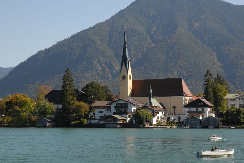
Тегернзе
- город в Баварии
Hiking in Тегернзе
Tegernsee, located in Bavaria, Germany, is a picturesque lake surrounded by the stunning Alps, making it a fantastic destination for hiking enthusiasts. Here are some highlights and information to consider when planning a hiking trip in the Tegernsee region:...
- Страна:
- Почтовый код: 83684
- Телефонный код: 08022
- Код автомобильного номера: MB
- Координаты: 47° 42' 31" N, 11° 45' 25" E
- GPS треки (wikiloc): [Ссылка]
- Высота над уровнем моря: 747 м m
- Площадь: 22.77 кв.км
- Население: 3880
- Веб сайт: [Ссылка]

Шлирзе
- община Германии
Hiking in Шлирзе
Schliersee is a charming destination in Bavaria, Germany, renowned for its stunning landscapes and numerous hiking opportunities. Nestled between the Schliersee lake and the surrounding mountains, it offers a variety of trails that cater to different skill levels, from leisurely strolls to more challenging hikes....
- Страна:
- Почтовый код: 83727
- Телефонный код: 08026
- Код автомобильного номера: MB
- Координаты: 47° 44' 0" N, 11° 52' 0" E
- GPS треки (wikiloc): [Ссылка]
- Высота над уровнем моря: 784 м m
- Площадь: 79.14 кв.км
- Население: 6799
- Веб сайт: [Ссылка]

Хольцкирхен
Hiking in Хольцкирхен
Holzkirchen, located in Upper Bavaria, is an excellent base for hiking enthusiasts due to its picturesque landscapes, proximity to the Alps, and variety of trails suitable for all levels of experience. Here are some highlights and tips for hiking in the area:...
- Страна:
- Почтовый код: 83607
- Телефонный код: 08024
- Код автомобильного номера: MB
- Координаты: 47° 53' 0" N, 11° 42' 0" E
- GPS треки (wikiloc): [Ссылка]
- Высота над уровнем моря: 691 м m
- Площадь: 48.33 кв.км
- Население: 10788
- Веб сайт: [Ссылка]

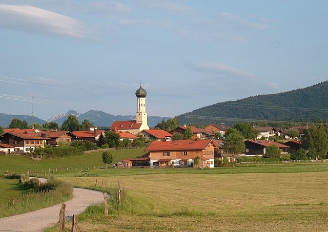
Мисбах
Hiking in Мисбах
Miesbach, located in Bavaria, Germany, offers a beautiful setting for hiking enthusiasts, surrounded by the stunning landscape of the Bavarian Alps. Here are some highlights of hiking in the Miesbach area:...
- Страна:
- Почтовый код: 83714
- Телефонный код: 08025
- Код автомобильного номера: MB
- Координаты: 47° 47' 21" N, 11° 50' 2" E
- GPS треки (wikiloc): [Ссылка]
- Высота над уровнем моря: 700 м m
- Площадь: 32.44 кв.км
- Население: 11477
- Веб сайт: [Ссылка]

Гмунд-ам-Тегернзе
Hiking in Гмунд-ам-Тегернзе
Gmund am Tegernsee is a picturesque village located at the northern end of Lake Tegernsee in Bavaria, Germany. It's a fantastic starting point for a variety of hiking trails that cater to different skill levels and preferences, making it popular with both locals and tourists....
- Страна:
- Почтовый код: 83703
- Телефонный код: 08025; 08022; 08021
- Код автомобильного номера: MB
- Координаты: 47° 45' 0" N, 11° 44' 0" E
- GPS треки (wikiloc): [Ссылка]
- Высота над уровнем моря: 740 м m
- Площадь: 34.40 кв.км
- Население: 6012
- Веб сайт: [Ссылка]

Оттерфинг
Hiking in Оттерфинг
Otterfing is a small town located in Bavaria, Germany, and while not as widely known as some of the larger tourist destinations in the region, it offers access to some beautiful hiking opportunities, particularly given its proximity to the scenic countryside and the foothills of the Alps....
- Страна:
- Почтовый код: 83624
- Телефонный код: 08024
- Код автомобильного номера: MB
- Координаты: 47° 55' 0" N, 11° 41' 0" E
- GPS треки (wikiloc): [Ссылка]
- Высота над уровнем моря: 675 м m
- Площадь: 18.40 кв.км
- Население: 3189
- Веб сайт: [Ссылка]

Бад-Висзе
Hiking in Бад-Висзе
Bad Wiessee, located in Bavaria, Germany, is a beautiful destination for hiking enthusiasts. Nestled along the shores of Tegernsee Lake and surrounded by the picturesque Bavarian Alps, it offers a variety of trails suitable for different skill levels. Here are some highlights of hiking in Bad Wiessee:...
- Страна:
- Почтовый код: 83707
- Телефонный код: 08022
- Код автомобильного номера: MB
- Координаты: 47° 43' 0" N, 11° 43' 0" E
- GPS треки (wikiloc): [Ссылка]
- Высота над уровнем моря: 740 м m
- Площадь: 32.79 кв.км
- Население: 4913
- Веб сайт: [Ссылка]

Кройт
- город в Германии
Hiking in Кройт
Kreuth is a charming village located in Bavaria, Germany, nestled in the foothills of the Alps near the shores of Tegernsee Lake. It's an excellent destination for hiking enthusiasts due to its beautiful landscapes, diverse trails, and stunning mountain views....
- Страна:
- Почтовый код: 83708
- Телефонный код: 08029
- Код автомобильного номера: MB
- Координаты: 47° 39' 0" N, 11° 45' 0" E
- GPS треки (wikiloc): [Ссылка]
- Высота над уровнем моря: 787 м m
- Площадь: 122.26 кв.км
- Население: 3637
- Веб сайт: [Ссылка]
Роттах-Эгерн
- населённый пункт в Баварии
Hiking in Роттах-Эгерн
Rottach-Egern, located in Bavaria, Germany, is a fantastic destination for hiking enthusiasts. Nestled at the foot of the majestic Tegernsee mountains, this picturesque village offers a variety of trails that cater to all levels of hikers, from beginners to experienced adventurers....
- Страна:
- Почтовый код: 83700
- Телефонный код: 08022
- Код автомобильного номера: MB
- Координаты: 47° 41' 23" N, 11° 46' 14" E
- GPS треки (wikiloc): [Ссылка]
- Высота над уровнем моря: 736 м m
- Площадь: 59.1 кв.км
- Население: 5733
- Веб сайт: [Ссылка]

Байришцелль
Hiking in Байришцелль
Bayrischzell is a scenic village located at the edge of the Bavarian Alps in Germany, making it a fantastic destination for hiking enthusiasts. Its stunning landscape combines lush valleys, alpine meadows, and impressive mountain peaks, providing various trails suitable for all levels of hikers....
- Страна:
- Почтовый код: 83735
- Телефонный код: 08023
- Код автомобильного номера: MB
- Координаты: 47° 40' 0" N, 12° 1' 0" E
- GPS треки (wikiloc): [Ссылка]
- Высота над уровнем моря: 800 м m
- Площадь: 79.46 кв.км
- Население: 1605
- Веб сайт: [Ссылка]

Хаусхам
Hiking in Хаусхам
Hausham, located in Bavaria, Germany, is a charming town surrounded by stunning natural landscapes, making it an excellent base for hiking enthusiasts. Here are some aspects to consider when hiking in and around Hausham:...
- Страна:
- Почтовый код: 83734
- Телефонный код: 08026
- Код автомобильного номера: MB
- Координаты: 47° 45' 0" N, 11° 51' 0" E
- GPS треки (wikiloc): [Ссылка]
- Высота над уровнем моря: 765 м m
- Площадь: 22.28 кв.км
- Население: 10289
- Веб сайт: [Ссылка]
Вакирхен
Hiking in Вакирхен
Waakirchen is a picturesque municipality located in Bavaria, Germany, near the beautiful Tegernsee and Schliersee lakes. It offers a variety of hiking trails suitable for all levels of hikers, making it a fantastic destination for outdoor enthusiasts....
- Страна:
- Почтовый код: 83666
- Телефонный код: 08021
- Код автомобильного номера: MB
- Координаты: 47° 46' 0" N, 11° 40' 0" E
- GPS треки (wikiloc): [Ссылка]
- Высота над уровнем моря: 759 м m
- Площадь: 42.31 кв.км
- Население: 4705
- Веб сайт: [Ссылка]

Вейарн
Hiking in Вейарн
Weyarn, located in Bavaria, Germany, offers beautiful landscapes and scenic trails for hiking enthusiasts. Nestled near the foothills of the Alps and alongside the picturesque Mangfall River, this area provides a range of hiking opportunities suitable for various experience levels....
- Страна:
- Почтовый код: 83629
- Телефонный код: 08020
- Код автомобильного номера: MB
- Координаты: 47° 51' 30" N, 11° 47' 57" E
- GPS треки (wikiloc): [Ссылка]
- Высота над уровнем моря: 671 м m
- Площадь: 46.68 кв.км
- Население: 3660
- Веб сайт: [Ссылка]

Варнгау
Hiking in Варнгау
Warngau is a charming municipality located in Bavaria, Germany, near the foothills of the Alps. It offers beautiful landscapes and a variety of hiking opportunities that cater to different skill levels, making it an appealing destination for outdoor enthusiasts....
- Страна:
- Почтовый код: 83627
- Телефонный код: 08021
- Код автомобильного номера: MB
- Координаты: 47° 50' 0" N, 11° 44' 0" E
- GPS треки (wikiloc): [Ссылка]
- Высота над уровнем моря: 744 м m
- Площадь: 51.28 кв.км
- Население: 2784
- Веб сайт: [Ссылка]

Фишбахау
Hiking in Фишбахау
Fischbachau is a picturesque village located in Bavaria, Germany, nestled in the foothills of the Alps. The region offers a variety of hiking opportunities, ranging from gentle trails suitable for families to more challenging hikes for seasoned adventurers. Here’s an overview of what you can expect when hiking in Fischbachau:...
- Страна:
- Почтовый код: 83730
- Телефонный код: 08028; 08025
- Код автомобильного номера: MB
- Координаты: 47° 43' 0" N, 11° 57' 0" E
- GPS треки (wikiloc): [Ссылка]
- Высота над уровнем моря: 771 м m
- Площадь: 75.91 кв.км
- Население: 4823
- Веб сайт: [Ссылка]

Фаллей
Hiking in Фаллей
Hiking in the Valley of Bavaria offers a diverse and stunning landscape that attracts outdoor enthusiasts from all over. The region is known for its picturesque valleys, rolling hills, dense forests, and the majestic backdrop of the Bavarian Alps. Here are some highlights and tips for your hiking experience in this beautiful area:...
- Страна:
- Почтовый код: 83626
- Телефонный код: 08024
- Код автомобильного номера: MB
- Координаты: 47° 54' 0" N, 11° 47' 0" E
- GPS треки (wikiloc): [Ссылка]
- Высота над уровнем моря: 650 м m
- Площадь: 42.09 кв.км
- Население: 2199
- Веб сайт: [Ссылка]
Граничит с регионами:

Бад-Тёльц-Вольфратсхаузен
- район Баварии
Hiking in Бад-Тёльц-Вольфратсхаузен
Bad Tölz-Wolfratshausen is a picturesque region in Bavaria, Germany, known for its stunning landscapes and excellent hiking opportunities. Nestled in the foothills of the Alps, this area offers a variety of trails that cater to different skill levels, from gentle walks suitable for families to more challenging hikes for experienced adventurers....
- Страна:
- Столица: Бад-Тёльц
- Код автомобильного номера: WOR; TÖL
- Координаты: 47° 45' 0" N, 11° 34' 48" E
- GPS треки (wikiloc): [Ссылка]
- Высота над уровнем моря: 848 м m
- Площадь: 1111.00 кв.км
- Население: 126572
- Веб сайт: [Ссылка]

Розенхайм
- район Баварии
Hiking in Розенхайм
Rosenheim district, located in Bavaria, Germany, offers a diverse range of hiking opportunities amidst beautiful landscapes, charming villages, and stunning natural scenery. Here are some highlights for hiking in the region:...
- Страна:
- Столица: Розенхайм
- Код автомобильного номера: WS; RO; AIB
- Координаты: 47° 55' 12" N, 12° 10' 12" E
- GPS треки (wikiloc): [Ссылка]
- Высота над уровнем моря: 512 м m
- Площадь: 1439.40 кв.км
- Население: 190104
- Веб сайт: [Ссылка]

Мюнхен
- район Баварии
Hiking in Мюнхен
Hiking in and around Munich, the capital of Bavaria, offers a wonderful blend of urban landscapes and stunning natural scenery. While Munich itself is a vibrant city with parks and green spaces, many hiking opportunities are just a short distance away in the surrounding region....
- Страна:
- Столица: Мюнхен
- Телефонный код: 089
- Код автомобильного номера: WOR; M; AIB
- Координаты: 48° 0' 0" N, 11° 40' 12" E
- GPS треки (wikiloc): [Ссылка]
- Высота над уровнем моря: 513 м m
- Площадь: 52020.58 кв.км
- Население: 343405
- Веб сайт: [Ссылка]

Куфштайн
Hiking in Куфштайн
The Kufstein District, located in the federal state of Tyrol, Austria, is a fantastic area for hiking enthusiasts. It features stunning alpine landscapes, charming villages, and well-established trails that cater to various skill levels....
- Страна:

- Столица: Куфштайн
- Код автомобильного номера: KU
- Координаты: 47° 30' 0" N, 12° 6' 0" E
- GPS треки (wikiloc): [Ссылка]
- Высота над уровнем моря: 646 м m
- Площадь: 969.90 кв.км
- Население: 105466
- Веб сайт: [Ссылка]


Швац
Hiking in Швац
Hiking in the Schwaz District, located in Tyrol, Austria, offers stunning landscapes, varied terrain, and a rich cultural experience. The area is surrounded by the impressive mountain ranges of the Alps, making it a fantastic location for both casual hikers and experienced trekkers....
- Страна:
- Столица: Швац
- Код автомобильного номера: SZ
- Координаты: 47° 24' 0" N, 11° 48' 0" E
- GPS треки (wikiloc): [Ссылка]
- Высота над уровнем моря: 1676 м m
- Площадь: 1843 кв.км
- Население: 81841
- Веб сайт: [Ссылка]