Пеноль (Penol, Penol)

- коммуна во Франции
 Hiking in Пеноль
Penol is a scenic destination in Colombia, particularly known for its stunning landscape dominated by the iconic El Peñol Rock (La Piedra del Peñol), which offers incredible views and challenging hikes. Here are some key points about hiking in the Penol area:
El Peñol Rock
- The Climb: The hike up El Peñol consists of about 740 steps leading to the summit. It’s not a technical climb, but it can be strenuous for some due to the elevation and the stairway's steepness.
- Views from the Top: Once you reach the top, you are rewarded with panoramic views of the Guatapé Reservoir and the surrounding lush green hills. It’s a popular spot for photography and enjoying the natural beauty of the area.
Surrounding Areas
- Guatapé: Nearby Guatapé is known for its colorful streets and vibrant waterfront. It’s a great place to explore after your hike, offering local shops, restaurants, and opportunities for water activities.
- Other Trails: There are various trails in the area that can be explored, ranging from easy walks around the lake to more challenging hikes in the surrounding hills. Always check local maps and signage for other hiking opportunities.
Best Time to Hike
- The best time to hike in Penol is typically during the dry seasons, which are from December to February and July to August. The weather is more stable, and the views are usually clearer.
Preparation Tips
- Gear: Wear sturdy hiking shoes, bring water, and consider sun protection like hats and sunscreen.
- Weather: Be prepared for changes in weather, as it can shift quickly in the mountains. Layers are advisable.
- Safety: Ensure that you are physically prepared for the climb, especially since the stairs can be taxing.
Access
- Transportation: Most visitors access El Peñol and Guatapé from Medellín, which is about two hours away by bus.
Overall, hiking in Penol is an exquisite experience, offering both adventure and breathtaking scenery. Remember to respect the nature and the trails, and enjoy your hike!
- Страна:

- Почтовый код: 38260
- Координаты: 45° 23' 25" N, 5° 11' 27" E


- GPS треки (wikiloc): [Ссылка]
- Площадь: 12.16 кв.км
- Население: 340
- Википедия русская: wiki(ru)
- Википедия английская: wiki(en)
- Википедия национальная: wiki(fr)
- Хранилище Wikidata: Wikidata: Q1068843
- Катеория в википедии: [Ссылка]
- код Freebase: [/m/03nvl0m]
- код GeoNames: Альт: [6433283]
- номер SIREN: [213803000]
- код BNF: [15258112f]
- код муниципалитета INSEE: 38300
Граничит с регионами:

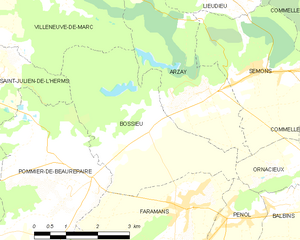
Босье
- коммуна во Франции
Hiking in Босье
Bossieu, a small commune in the Isère department of southeastern France, offers some charming opportunities for hiking enthusiasts. The region is characterized by its picturesque landscapes, which include rolling hills, forests, and views of the surrounding mountains....
- Страна:
- Почтовый код: 38260
- Координаты: 45° 25' 1" N, 5° 8' 53" E
- GPS треки (wikiloc): [Ссылка]
- Площадь: 13.48 кв.км
- Население: 281
- Веб сайт: [Ссылка]

Бальбен
- коммуна во Франции
Hiking in Бальбен
It seems like you might be referring to a specific location, but "Balbins" isn't widely recognized as a hiking destination. If you meant a different place, please clarify the name or provide more details....
- Страна:
- Почтовый код: 38260
- Координаты: 45° 23' 54" N, 5° 12' 51" E
- GPS треки (wikiloc): [Ссылка]
- Площадь: 7.26 кв.км
- Население: 432
- Веб сайт: [Ссылка]


Тодюр
- коммуна во Франции
Hiking in Тодюр
Thodure is a picturesque village located in the southern part of India, specifically in the state of Tamil Nadu. It is known for its serene landscapes, lush greenery, and accessible trails that attract both amateur and seasoned hikers. Here are some key points to consider for hiking in Thodure:...
- Страна:
- Почтовый код: 38260
- Координаты: 45° 19' 0" N, 5° 10' 7" E
- GPS треки (wikiloc): [Ссылка]
- Площадь: 14.43 кв.км
- Население: 745


Паже
- коммуна во Франции
Hiking in Паже
Pajay, likely referring to a less commonly known hiking area, might not have extensive resources or documented trails like more popular hiking destinations. However, if Pajay is situated in a mountainous or nature-rich region, I can guide you on typical hiking experiences that such areas might offer....
- Страна:
- Почтовый код: 38260
- Координаты: 45° 21' 50" N, 5° 8' 22" E
- GPS треки (wikiloc): [Ссылка]
- Площадь: 14.32 кв.км
- Население: 1126
- Веб сайт: [Ссылка]


Орнасьё
- коммуна во Франции
Hiking in Орнасьё
Ornacieux is a charming village located in the Rhône-Alpes region of France, surrounded by beautiful natural landscapes, making it a great destination for hiking enthusiasts. The area offers a variety of trails that cater to different skill levels, from leisurely walks to more challenging hikes....
- Страна:
- Почтовый код: 38260
- Координаты: 45° 24' 2" N, 5° 12' 40" E
- GPS треки (wikiloc): [Ссылка]
- Площадь: 4.89 кв.км
- Население: 416


Марсийоль
- коммуна во Франции
Hiking in Марсийоль
Marcilloles is a charming village located in the scenic region of Auvergne-Rhône-Alpes in France. It's well-known for its stunning natural surroundings, making it an excellent destination for hiking enthusiasts. Here’s what you can expect when hiking in this area:...
- Страна:
- Почтовый код: 38260
- Координаты: 45° 20' 24" N, 5° 11' 2" E
- GPS треки (wikiloc): [Ссылка]
- Площадь: 9.5 кв.км
- Население: 1056
- Веб сайт: [Ссылка]
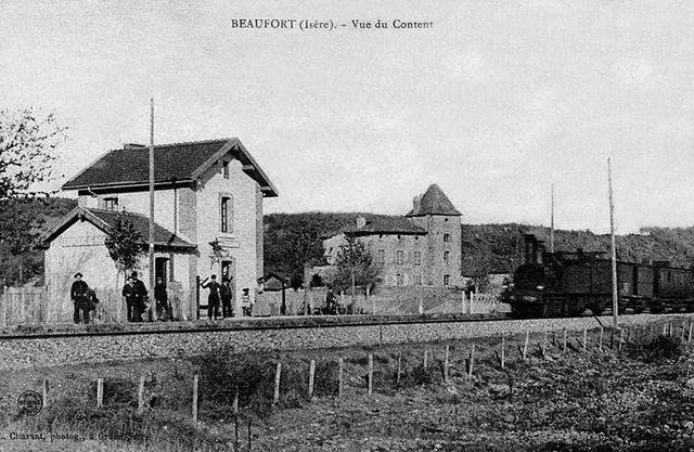

Бофор
- коммуна - Рона — Альпы, Изер, Гренобль
Hiking in Бофор
Beaufort, located in the Isère department of the Auvergne-Rhône-Alpes region in southeastern France, is a charming area known for its stunning alpine scenery and diverse hiking opportunities. Here are some highlights about hiking in this region:...
- Страна:
- Почтовый код: 38270
- Координаты: 45° 19' 35" N, 5° 7' 19" E
- GPS треки (wikiloc): [Ссылка]
- Высота над уровнем моря: 280 м m
- Площадь: 8.69 кв.км
- Население: 564
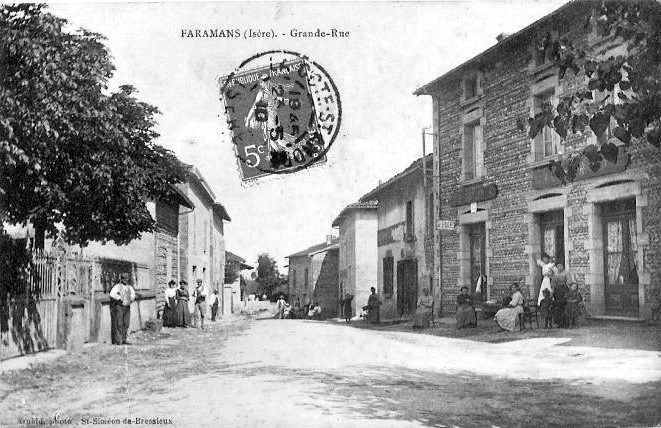

Фараман
Hiking in Фараман
Faramans is a small commune located in the Isère department in the Auvergne-Rhône-Alpes region of southeastern France. While it may not be as well-known as some of the larger hiking destinations in the area, it offers beautiful landscapes and a chance to enjoy nature in a quieter setting....
- Страна:
- Почтовый код: 38260
- Координаты: 45° 23' 36" N, 5° 9' 49" E
- GPS треки (wikiloc): [Ссылка]
- Площадь: 10.79 кв.км
- Население: 1017
- Веб сайт: [Ссылка]


Сардьё
- коммуна во Франции
Hiking in Сардьё
Sardieu is a beautiful destination for hiking, located in the Isère department of France, near the foothills of the Alps. This region is known for its scenic landscapes, diverse terrain, and beautiful views, making it a great spot for outdoor enthusiasts....
- Страна:
- Почтовый код: 38260
- Координаты: 45° 22' 9" N, 5° 12' 43" E
- GPS треки (wikiloc): [Ссылка]
- Высота над уровнем моря: 358 м m
- Площадь: 11.2 кв.км
- Население: 1097
- Веб сайт: [Ссылка]