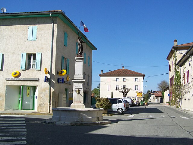
Сен-Бонне-де-Шавань (Saint-Bonnet-de-Chavagne, Saint-Bonnet-de-Chavagne)

- коммуна во Франции
 Hiking in Сен-Бонне-де-Шавань
Saint-Bonnet-de-Chavagne is a charming village located in the Isère department of the Auvergne-Rhône-Alpes region in France. It is surrounded by the natural beauty of the Vercors and Chartreuse mountain ranges, making it a great destination for hiking enthusiasts.
Hiking Trails:
-
Local Trails: There are several local hiking paths that take you through forests, meadows, and offer stunning views of the surrounding mountains. The trails vary in difficulty, catering to both beginners and experienced hikers.
-
Vercors Regional Natural Park: Just a short drive away, this park features a vast network of trails with diverse landscapes, including limestone cliffs, deep gorges, and rich flora and fauna. Popular trails include the Gorges de la Bourne and the path to the Col de Rousset.
-
Chartreuse Mountains: On the opposite side, the Chartreuse range provides another hiking playground. The trails here often lead to picturesque viewpoints and places of historical significance, such as the Grande Chartreuse monastery.
Recommendations:
- Season: The best time for hiking in this area is typically from spring to early autumn (April to October) when the weather is milder, and the landscapes are lush and vibrant.
- Maps and Guides: Carry a local hiking map or guidebook, as some trails may not be well marked. The tourist office in nearby towns can be a good resource for trail information.
- Safety: Ensure you have appropriate hiking gear, sufficient water, and snacks. Always inform someone of your planned route and estimated return time.
Accessibility:
Saint-Bonnet-de-Chavagne can be accessed by car, and there are public transport options available from larger nearby towns. The area is not overly touristy, which allows for a more peaceful hiking experience.
Overall, hiking around Saint-Bonnet-de-Chavagne offers a wonderful opportunity to enjoy the tranquility and beauty of French nature while providing options for all skill levels.
- Страна:

- Почтовый код: 38840
- Координаты: 45° 7' 33" N, 5° 13' 55" E


- GPS треки (wikiloc): [Ссылка]
- Площадь: 15.18 кв.км
- Население: 631
- Веб сайт: http://www.saint-bonnet-de-chavagne.fr
- Википедия русская: wiki(ru)
- Википедия английская: wiki(en)
- Википедия национальная: wiki(fr)
- Хранилище Wikidata: Wikidata: Q1067981
- Катеория в википедии: [Ссылка]
- код Freebase: [/m/03g_5y3]
- код GeoNames: Альт: [6433328]
- номер SIREN: [213803703]
- код BNF: [152581818]
- код VIAF: Альт: [146923449]
- код LCNAF: Альт: [no2003063190]
- код муниципалитета INSEE: 38370
Граничит с регионами:


Сен-Латье
- коммуна во Франции
Hiking in Сен-Латье
Saint-Lattier is a charming town located in the Isère department of the Auvergne-Rhône-Alpes region in southeastern France. It's surrounded by beautiful natural landscapes, which makes it an excellent destination for hiking enthusiasts....
- Страна:
- Почтовый код: 38840
- Координаты: 45° 5' 16" N, 5° 12' 4" E
- GPS треки (wikiloc): [Ссылка]
- Площадь: 18.17 кв.км
- Население: 1280
- Веб сайт: [Ссылка]


Монтань
Hiking in Монтань
Montagne, located in the Isère department of the Auvergne-Rhône-Alpes region in France, offers a variety of beautiful hiking opportunities suitable for different skill levels. This area is characterized by its stunning mountain landscapes, lush valleys, and diverse flora and fauna....
- Страна:
- Почтовый код: 38160
- Координаты: 45° 8' 28" N, 5° 11' 32" E
- GPS треки (wikiloc): [Ссылка]
- Площадь: 8.78 кв.км
- Население: 265


Сент-Илер-дю-Розье
- коммуна во Франции
Hiking in Сент-Илер-дю-Розье
Saint-Hilaire-du-Rosier is a small commune located in the Drôme department of southeastern France. It is situated in a picturesque region that features a mix of natural beauty, charming rural landscapes, and proximity to various hiking opportunities....
- Страна:
- Почтовый код: 38840
- Координаты: 45° 6' 3" N, 5° 14' 53" E
- GPS треки (wikiloc): [Ссылка]
- Площадь: 16.42 кв.км
- Население: 1921
- Веб сайт: [Ссылка]

Шат
- коммуна во Франции
Hiking in Шат
It seems like you might be referring to a location that could be spelled differently or may not be widely recognized as a hiking destination. If you meant "Chattahoochee" or other known areas, please clarify. However, if you are referring to a lesser-known area, here's a general guide on how to approach hiking in any location:...
- Страна:
- Почтовый код: 38160
- Координаты: 45° 8' 37" N, 5° 16' 59" E
- GPS треки (wikiloc): [Ссылка]
- Площадь: 22.81 кв.км
- Население: 2496
- Веб сайт: [Ссылка]

Сент-Антуан-л'Аббеи
- коммуна во Франции
Hiking in Сент-Антуан-л'Аббеи
Saint-Antoine-l'Abbaye, located in the Isère department of France, offers some wonderful hiking opportunities set against a backdrop of historical architecture and picturesque landscapes. The region is known for its medieval abbey, which adds cultural significance to your outdoor adventures....
- Страна:
- Почтовый код: 38160
- Координаты: 45° 10' 30" N, 5° 13' 0" E
- GPS треки (wikiloc): [Ссылка]
- Площадь: 22.21 кв.км
- Население: 1053
- Веб сайт: [Ссылка]