Шат (Chatte, Chatte)

- коммуна во Франции
 Hiking in Шат
It seems like you might be referring to a location that could be spelled differently or may not be widely recognized as a hiking destination. If you meant "Chattahoochee" or other known areas, please clarify. However, if you are referring to a lesser-known area, here's a general guide on how to approach hiking in any location:
-
Research the Area: Look into local trails, parks, and natural reserves. Websites such as AllTrails can provide you with trail maps, reviews, and photos from other hikers.
-
Check Trail Difficulty: Trails vary in difficulty from easy strolls to challenging hikes. Ensure you choose one that matches your fitness level and experience.
-
Know the Weather: Before heading out, check the weather forecast. Conditions can change rapidly, especially in mountainous areas.
-
Prepare Proper Gear:
- Footwear: Invest in sturdy, comfortable hiking boots.
- Clothing: Dress in layers to adjust to changing temperatures.
- Essentials: Pack a map, compass, first aid kit, water, snacks, and a multi-tool.
-
Safety First:
- Inform someone of your plans and expected return time.
- Stay on marked trails and adhere to any park regulations.
- Bring a phone or GPS device, but be aware of possible dead spots in remote areas.
-
Leave No Trace: Follow the principles of Leave No Trace by packing out what you pack in, staying on trails, and respecting wildlife.
-
Enjoy: Take time to soak in the views, the sounds of nature, and whatever unique features the area has to offer.
If you have a specific destination in mind, please provide more details, and I'll be happy to help you with targeted information!
- Страна:

- Почтовый код: 38160
- Координаты: 45° 8' 37" N, 5° 16' 59" E


- GPS треки (wikiloc): [Ссылка]
- Площадь: 22.81 кв.км
- Население: 2496
- Веб сайт: http://www.commune-chatte.fr
- Википедия русская: wiki(ru)
- Википедия английская: wiki(en)
- Википедия национальная: wiki(fr)
- Хранилище Wikidata: Wikidata: Q574139
- Катеория в википедии: [Ссылка]
- код Freebase: [/m/03m3ymr]
- код GeoNames: Альт: [6448758]
- номер SIREN: [213800956]
- код BNF: [15257922q]
- код муниципалитета INSEE: 38095
Граничит с регионами:


Шевриер
- коммуна во Франции
Hiking in Шевриер
Chevrières is a small village in the Isère department of the Auvergne-Rhône-Alpes region in southeastern France. While it may not be as well-known as some larger hiking destinations, it is surrounded by beautiful landscapes and offers opportunities for outdoor activities, including hiking....
- Страна:
- Почтовый код: 38160
- Координаты: 45° 11' 15" N, 5° 17' 25" E
- GPS треки (wikiloc): [Ссылка]
- Площадь: 16.62 кв.км
- Население: 710
- Веб сайт: [Ссылка]


Ла-Сон
Hiking in Ла-Сон
La Sône is a charming commune located in the Auvergne-Rhône-Alpes region of France, surrounded by beautiful natural landscapes. While it may not be as widely known as some of the larger hiking destinations in the Alps, it offers a variety of scenic trails that cater to different skill levels....
- Страна:
- Почтовый код: 38840
- Координаты: 45° 6' 41" N, 5° 16' 41" E
- GPS треки (wikiloc): [Ссылка]
- Площадь: 2.95 кв.км
- Население: 579
- Веб сайт: [Ссылка]


Сен-Бонне-де-Шавань
- коммуна во Франции
Hiking in Сен-Бонне-де-Шавань
Saint-Bonnet-de-Chavagne is a charming village located in the Isère department of the Auvergne-Rhône-Alpes region in France. It is surrounded by the natural beauty of the Vercors and Chartreuse mountain ranges, making it a great destination for hiking enthusiasts....
- Страна:
- Почтовый код: 38840
- Координаты: 45° 7' 33" N, 5° 13' 55" E
- GPS треки (wikiloc): [Ссылка]
- Площадь: 15.18 кв.км
- Население: 631
- Веб сайт: [Ссылка]
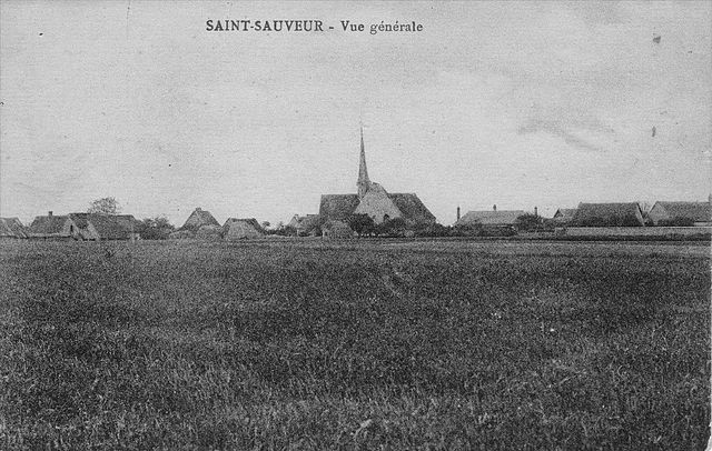
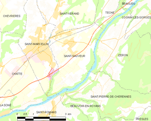
Сен-Совёр
Hiking in Сен-Совёр
Saint-Sauveur is a charming village located in the Isère department of the Auvergne-Rhône-Alpes region in southeastern France. It's known for its beautiful natural landscapes, making it a great destination for hiking enthusiasts....
- Страна:
- Почтовый код: 38160
- Координаты: 45° 9' 9" N, 5° 20' 31" E
- GPS треки (wikiloc): [Ссылка]
- Площадь: 9.42 кв.км
- Население: 2100
- Веб сайт: [Ссылка]

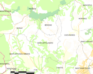
Сент-Апполинар
- коммуна во Франции
Hiking in Сент-Апполинар
Saint-Appolinard is a charming commune located in the Isère department in the Auvergne-Rhône-Alpes region of southeastern France. Known for its picturesque landscapes, it offers a variety of hiking opportunities suitable for different skill levels. Here are some highlights and tips for hiking in the area:...
- Страна:
- Почтовый код: 38160
- Координаты: 45° 11' 20" N, 5° 15' 45" E
- GPS треки (wikiloc): [Ссылка]
- Высота над уровнем моря: 380 м m
- Площадь: 10.76 кв.км
- Население: 400
- Веб сайт: [Ссылка]


Сент-Илер-дю-Розье
- коммуна во Франции
Hiking in Сент-Илер-дю-Розье
Saint-Hilaire-du-Rosier is a small commune located in the Drôme department of southeastern France. It is situated in a picturesque region that features a mix of natural beauty, charming rural landscapes, and proximity to various hiking opportunities....
- Страна:
- Почтовый код: 38840
- Координаты: 45° 6' 3" N, 5° 14' 53" E
- GPS треки (wikiloc): [Ссылка]
- Площадь: 16.42 кв.км
- Население: 1921
- Веб сайт: [Ссылка]


Сен-Марселлен
- коммуна во Франции
Hiking in Сен-Марселлен
Saint-Marcellin, located in the Isère department of the Auvergne-Rhône-Alpes region in southeastern France, is surrounded by beautiful natural landscapes, making it an excellent destination for hiking enthusiasts. The area features a mix of rolling hills, lush forests, and stunning views of the Vercors and Chartreuse mountains....
- Страна:
- Почтовый код: 38160
- Координаты: 45° 9' 6" N, 5° 19' 11" E
- GPS треки (wikiloc): [Ссылка]
- Высота над уровнем моря: 300 м m
- Площадь: 7.81 кв.км
- Население: 8133
- Веб сайт: [Ссылка]

Сент-Антуан-л'Аббеи
- коммуна во Франции
Hiking in Сент-Антуан-л'Аббеи
Saint-Antoine-l'Abbaye, located in the Isère department of France, offers some wonderful hiking opportunities set against a backdrop of historical architecture and picturesque landscapes. The region is known for its medieval abbey, which adds cultural significance to your outdoor adventures....
- Страна:
- Почтовый код: 38160
- Координаты: 45° 10' 30" N, 5° 13' 0" E
- GPS треки (wikiloc): [Ссылка]
- Площадь: 22.21 кв.км
- Население: 1053
- Веб сайт: [Ссылка]


Сен-Роман
- коммуна во Франции
Hiking in Сен-Роман
Saint-Romans is a picturesque village located in the Isère department of the Auvergne-Rhône-Alpes region in southeastern France. This location offers various hiking opportunities for both novice and experienced hikers. Here are some highlights to consider when hiking in and around Saint-Romans:...
- Страна:
- Почтовый код: 38160
- Координаты: 45° 6' 57" N, 5° 19' 37" E
- GPS треки (wikiloc): [Ссылка]
- Площадь: 17.04 кв.км
- Население: 1786
- Веб сайт: [Ссылка]