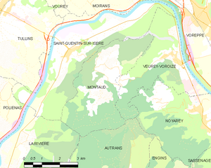
Сен-Кантен-сюр-Изер (Saint-Quentin-sur-Isère, Saint-Quentin-sur-Isère)

- коммуна во Франции
 Hiking in Сен-Кантен-сюр-Изер
Saint-Quentin-sur-Isère, located in the Isère department of France, is surrounded by beautiful landscapes that are perfect for hiking enthusiasts. The region features a mix of rolling hills, forests, and views of the nearby Alps, making it a great destination for hiking.
Hiking Opportunities
-
Trails and Routes: There are various marked trails in and around Saint-Quentin-sur-Isère, ranging from easy walks to more challenging hikes. Popular routes often include paths that lead to picturesque viewpoints, rivers, and local flora and fauna.
-
Nearby Natural Parks: The Trièves region and Vercors Regional Natural Park are not far away, offering extensive hiking trails and breathtaking scenery. These parks provide a range of hikes, from leisurely walks to rigorous mountain treks.
-
Scenic Views: Many trails in this area offer stunning panoramic views of the surrounding mountains, valleys, and the Isère river, making them ideal for both casual hikers and photographers.
Tips for Hiking in Saint-Quentin-sur-Isère
- Check Trail Conditions: Before heading out, it's wise to check the conditions of the trails, especially after rain or during the winter months when trails may be snow-covered.
- Maps and Guides: Make use of local maps and guides to explore the area safely. Some trails may not be well-marked.
- Gear: Wear appropriate hiking gear, including sturdy boots, and bring plenty of water and snacks. Weather can change quickly in mountainous areas, so layers are advisable.
- Respect Nature: Follow the "Leave No Trace" principles to ensure the preservation of the natural environment.
Best Times to Hike
- Spring and Fall: These seasons typically offer mild weather and beautiful scenery with blooming flowers in spring and colorful foliage in fall.
- Summer: Though it can get hot, summer is a great time to enjoy longer daylight hours and fully experience the natural beauty of the region.
Hiking in and around Saint-Quentin-sur-Isère can be a rewarding way to explore the natural beauty of the French Alps while enjoying physical activity in a stunning environment.
- Страна:

- Почтовый код: 38210
- Координаты: 45° 16' 45" N, 5° 32' 32" E


- GPS треки (wikiloc): [Ссылка]
- Площадь: 19.45 кв.км
- Население: 1396
- Веб сайт: http://www.saint-quentin-sur-isere.fr
- Википедия русская: wiki(ru)
- Википедия английская: wiki(en)
- Википедия национальная: wiki(fr)
- Хранилище Wikidata: Wikidata: Q1068468
- Катеория в википедии: [Ссылка]
- код Freebase: [/m/03nvhgt]
- номер SIREN: [213804503]
- код BNF: [15258257p]
- код VIAF: Альт: [132264434]
- код муниципалитета INSEE: 38450
Граничит с регионами:


Вуре
- коммуна во Франции
Hiking in Вуре
Vourey is a charming village located in the Auvergne-Rhône-Alpes region of France, surrounded by picturesque landscapes ideal for hiking enthusiasts. The area offers a variety of trails that cater to different skill levels, from easy walks through scenic meadows to more challenging hikes that lead into the nearby hills and forests....
- Страна:
- Почтовый код: 38210
- Координаты: 45° 19' 15" N, 5° 31' 12" E
- GPS треки (wikiloc): [Ссылка]
- Площадь: 6.88 кв.км
- Население: 1711
- Веб сайт: [Ссылка]


Ла-Ривьер
Hiking in Ла-Ривьер
La Rivière is a beautiful commune located in the Isère department of the Auvergne-Rhône-Alpes region in southeastern France. The area is characterized by stunning natural landscapes, mountains, and rivers, making it an excellent destination for hiking enthusiasts....
- Страна:
- Почтовый код: 38210
- Координаты: 45° 14' 13" N, 5° 30' 29" E
- GPS треки (wikiloc): [Ссылка]
- Площадь: 18.45 кв.км
- Население: 770

Монто
Hiking in Монто
Montaud, located in the Isère department in the Auvergne-Rhône-Alpes region of France, is a lesser-known gem for hiking enthusiasts. Nestled in the beautiful French Alps, it offers a combination of stunning landscapes, varied terrains, and a rich variety of flora and fauna....
- Страна:
- Почтовый код: 38210
- Координаты: 45° 15' 46" N, 5° 33' 40" E
- GPS треки (wikiloc): [Ссылка]
- Площадь: 14.59 кв.км
- Население: 537
- Веб сайт: [Ссылка]


Вёре-Воруаз
- коммуна во Франции
Hiking in Вёре-Воруаз
Veurey-Voroize is a charming commune located near Grenoble in the Auvergne-Rhône-Alpes region of France. It is surrounded by scenic landscapes and mountains, making it an attractive destination for hiking enthusiasts....
- Страна:
- Почтовый код: 38113
- Координаты: 45° 16' 20" N, 5° 36' 52" E
- GPS треки (wikiloc): [Ссылка]
- Площадь: 12.21 кв.км
- Население: 1444
- Веб сайт: [Ссылка]


Муаран
- коммуна во Франции
Hiking in Муаран
Moirans, located in the Auvergne-Rhône-Alpes region of France, is surrounded by beautiful landscapes that are perfect for hiking enthusiasts. Here are some key points to consider if you're planning a hiking trip in this area:...
- Страна:
- Почтовый код: 38430
- Координаты: 45° 19' 30" N, 5° 33' 52" E
- GPS треки (wikiloc): [Ссылка]
- Площадь: 20.06 кв.км
- Население: 8022
- Веб сайт: [Ссылка]


Тюллен
- коммуна во Франции
Hiking in Тюллен
Tullins is a charming town located in the Isère department of the Auvergne-Rhône-Alpes region in southeastern France. It's ideally situated near the French Alps, offering access to a range of hiking opportunities that cater to various skill levels....
- Страна:
- Почтовый код: 38210
- Координаты: 45° 17' 51" N, 5° 29' 0" E
- GPS треки (wikiloc): [Ссылка]
- Площадь: 28.79 кв.км
- Население: 7655
- Веб сайт: [Ссылка]


Вореп
- коммуна во Франции
Hiking in Вореп
Voreppe, located in the Isère department of southeastern France, is a picturesque area that offers various hiking opportunities amid stunning natural landscapes. The proximity to the Chartreuse and Vercors mountain ranges makes it an ideal base for outdoor enthusiasts....
- Страна:
- Почтовый код: 38340
- Координаты: 45° 17' 52" N, 5° 38' 13" E
- GPS треки (wikiloc): [Ссылка]
- Площадь: 28.65 кв.км
- Население: 9441
- Веб сайт: [Ссылка]

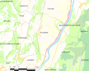
Польенас
- коммуна во Франции
Hiking in Польенас
Poliénas, a charming commune in the Isère department of southeastern France, is well situated for outdoor activities, including hiking. Nestled near the foothills of the Alps, the area offers stunning natural landscapes, diverse terrain, and numerous trails suitable for various skill levels....
- Страна:
- Почтовый код: 38210
- Координаты: 45° 14' 56" N, 5° 28' 17" E
- GPS треки (wikiloc): [Ссылка]
- Площадь: 14.03 кв.км
- Население: 1150
- Веб сайт: [Ссылка]