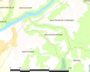
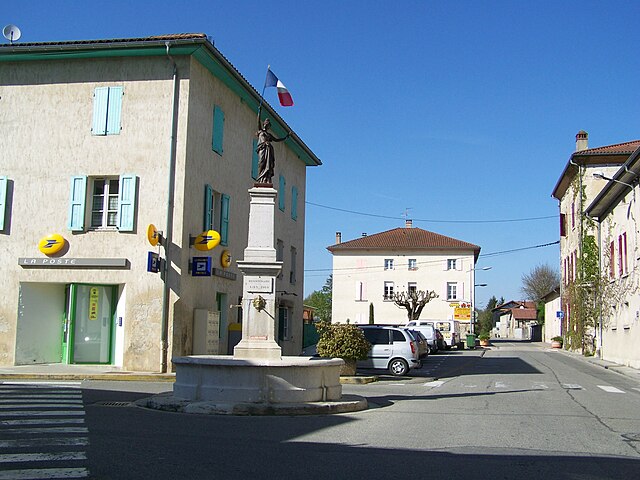
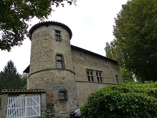
Сен-Совёр (Saint-Sauveur, Saint-Sauveur)

 Hiking in Сен-Совёр
Saint-Sauveur is a charming village located in the Isère department of the Auvergne-Rhône-Alpes region in southeastern France. It's known for its beautiful natural landscapes, making it a great destination for hiking enthusiasts.
Hiking Trails
-
Le Mont Aiguille: This iconic mountain offers stunning views and is the centerpiece of the Vercors Regional Natural Park. The hike to Mont Aiguille requires a good fitness level and some technical climbing skills, but the panoramic views from the top are rewarding.
-
Les Gorges de la Bourne: This trail takes you along the dramatic gorges of the Bourne River, with options for different levels of hikers. The path is generally well-marked and allows you to enjoy the cliffs, waterfalls, and lush vegetation.
-
La Résurgence de la Bourne: A relatively easy hike that leads to the resurgence of the Bourne River. It features beautiful scenery and is suitable for families and beginners.
-
Vercors Plateau: The plains and plateau areas provide less strenuous hiking options, with panoramic views and opportunities for wildlife spotting. The trails here are typically well-maintained.
Best Time to Hike
The best times for hiking around Saint-Sauveur are during spring (April to June) and autumn (September to October) when the weather is generally mild, and the landscape is vibrant with seasonal flora. Summer can also be great, although it can get quite hot, so starting hikes early in the day is advisable.
Tips for Hiking
- Gear Up: Wear sturdy hiking boots and dress in layers to adjust to changing weather conditions.
- Stay Hydrated: Carry enough water and some snacks, especially on longer trails.
- Maps and Navigation: While many trails are marked, having a map or a GPS application is helpful for navigation.
- Local Guidelines: Respect wildlife and stay on designated paths to preserve the natural environment.
Accessibility
Saint-Sauveur is accessible by car, and several nearby towns provide additional access points to hiking trails. Public transportation options may be limited, so planning ahead is recommended.
Whether you are looking for challenging hikes or family-friendly walks, Saint-Sauveur offers a lovely experience in the heart of the French Alps. Always check local conditions before heading out and enjoy your hiking adventure!
- Страна:

- Почтовый код: 38160
- Координаты: 45° 9' 9" N, 5° 20' 31" E


- GPS треки (wikiloc): [Ссылка]
- Площадь: 9.42 кв.км
- Население: 2100
- Веб сайт: http://www.saintsauveur38.fr
- Википедия русская: wiki(ru)
- Википедия английская: wiki(en)
- Википедия национальная: wiki(fr)
- Хранилище Wikidata: Wikidata: Q1068123
- Катеория в википедии: [Ссылка]
- код Freebase: [/m/03nw7tc]
- номер SIREN: [213804545]
- код BNF: [15258261x]
- код муниципалитета INSEE: 38454
Граничит с регионами:


Теш
- коммуна во Франции
Hiking in Теш
Têche is a beautiful region that is often celebrated for its picturesque landscapes, diverse ecosystems, and extensive trail networks, making it an excellent destination for hiking enthusiasts. Although specific details may vary, here are general aspects to consider when hiking in Têche:...
- Страна:
- Почтовый код: 38470
- Координаты: 45° 10' 58" N, 5° 22' 53" E
- GPS треки (wikiloc): [Ссылка]
- Площадь: 5.03 кв.км
- Население: 578
- Веб сайт: [Ссылка]

Бовуар-ан-Руаян
- коммуна во Франции
Hiking in Бовуар-ан-Руаян
Beauvoir-en-Royans is a charming village located in the Drôme department in southeastern France, nestled in the picturesque landscapes of the Vercors Regional Natural Park. This area is known for its stunning natural beauty, making it an excellent destination for hiking enthusiasts....
- Страна:
- Почтовый код: 38160
- Координаты: 45° 7' 15" N, 5° 20' 17" E
- GPS треки (wikiloc): [Ссылка]
- Высота над уровнем моря: 281 м m
- Площадь: 2.1 кв.км
- Население: 89


Сен-Марселлен
- коммуна во Франции
Hiking in Сен-Марселлен
Saint-Marcellin, located in the Isère department of the Auvergne-Rhône-Alpes region in southeastern France, is surrounded by beautiful natural landscapes, making it an excellent destination for hiking enthusiasts. The area features a mix of rolling hills, lush forests, and stunning views of the Vercors and Chartreuse mountains....
- Страна:
- Почтовый код: 38160
- Координаты: 45° 9' 6" N, 5° 19' 11" E
- GPS треки (wikiloc): [Ссылка]
- Высота над уровнем моря: 300 м m
- Площадь: 7.81 кв.км
- Население: 8133
- Веб сайт: [Ссылка]

Шат
- коммуна во Франции
Hiking in Шат
It seems like you might be referring to a location that could be spelled differently or may not be widely recognized as a hiking destination. If you meant "Chattahoochee" or other known areas, please clarify. However, if you are referring to a lesser-known area, here's a general guide on how to approach hiking in any location:...
- Страна:
- Почтовый код: 38160
- Координаты: 45° 8' 37" N, 5° 16' 59" E
- GPS треки (wikiloc): [Ссылка]
- Площадь: 22.81 кв.км
- Население: 2496
- Веб сайт: [Ссылка]
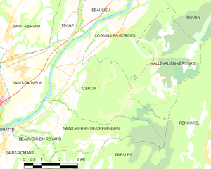
Изрон
- коммуна во Франции
Hiking in Изрон
Izeron is a charming village located in the Isère department of southeastern France, not far from the Vercors National Park. The surrounding area is characterized by its beautiful landscapes, diverse flora and fauna, and a variety of hiking trails that cater to different skill levels....
- Страна:
- Почтовый код: 38160
- Координаты: 45° 8' 48" N, 5° 22' 33" E
- GPS треки (wikiloc): [Ссылка]
- Площадь: 17.19 кв.км
- Население: 701
- Веб сайт: [Ссылка]

Сен-Веран
Hiking in Сен-Веран
Saint-Vérand is a charming village located in the Isère department of the Auvergne-Rhône-Alpes region in southeastern France. It is nestled in the foothills of the Alps and offers a variety of hiking opportunities that showcase the stunning natural landscapes of the area....
- Страна:
- Почтовый код: 38160
- Координаты: 45° 10' 23" N, 5° 19' 54" E
- GPS треки (wikiloc): [Ссылка]
- Высота над уровнем моря: 290 м m
- Площадь: 17.83 кв.км
- Население: 1727
- Веб сайт: [Ссылка]


Сен-Роман
- коммуна во Франции
Hiking in Сен-Роман
Saint-Romans is a picturesque village located in the Isère department of the Auvergne-Rhône-Alpes region in southeastern France. This location offers various hiking opportunities for both novice and experienced hikers. Here are some highlights to consider when hiking in and around Saint-Romans:...
- Страна:
- Почтовый код: 38160
- Координаты: 45° 6' 57" N, 5° 19' 37" E
- GPS треки (wikiloc): [Ссылка]
- Площадь: 17.04 кв.км
- Население: 1786
- Веб сайт: [Ссылка]

Сен-Пьер-де-Шерен
- коммуна во Франции
Hiking in Сен-Пьер-де-Шерен
Saint-Pierre-de-Chérennes, located in the Isère department of the Auvergne-Rhône-Alpes region in southeastern France, offers a picturesque setting for hiking enthusiasts. The surrounding landscapes are characterized by rolling hills, lush forests, and stunning views of the nearby mountains, making it an ideal location for outdoor activities....
- Страна:
- Почтовый код: 38160
- Координаты: 45° 7' 15" N, 5° 21' 44" E
- GPS треки (wikiloc): [Ссылка]
- Площадь: 12.03 кв.км
- Население: 477
- Веб сайт: [Ссылка]