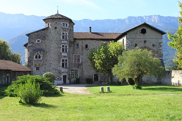
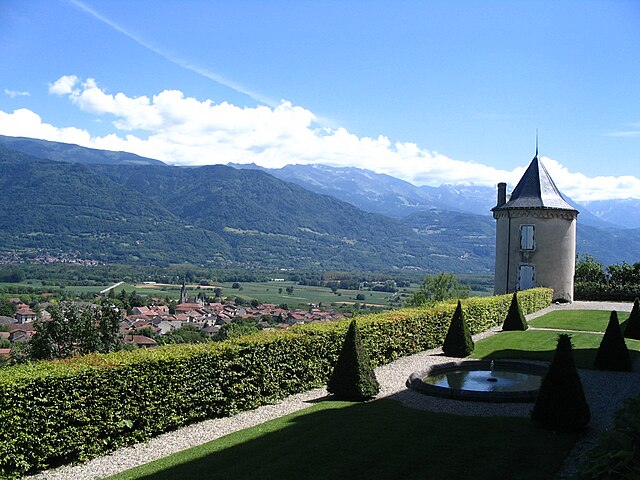
Сен-Венсан-де-Меркюз (Saint-Vincent-de-Mercuze, Saint-Vincent-de-Mercuze)

- коммуна во Франции
 Hiking in Сен-Венсан-де-Меркюз
Saint-Vincent-de-Mercuze, located in the Isère department of the Auvergne-Rhône-Alpes region in southeastern France, offers a variety of hiking opportunities amidst beautiful natural landscapes. Here are some highlights of hiking in this area:
Scenic Trails
-
Variety of Trails: The region has a network of trails that cater to different skill levels, from easier family-friendly walks to more challenging hikes suitable for experienced trekkers.
-
Stunning Views: Many trails provide breathtaking views of the surrounding mountains, valleys, and, on clear days, you can see the peaks of the Alps in the distance.
-
Natural Features: Hikers can enjoy a mix of forested areas, rocky terrain, and meadows. Look for unique flora and fauna that inhabit the region.
Key Hiking Routes
-
Les Crêtes de Saint-Vincent: A popular trail that leads you along the ridges and offers panoramic views of the surrounding landscape.
-
Col de la Placette: This route offers a moderate hike with scenic views and a chance to explore local wildlife and plant species.
-
Local Nature Reserves: Some trails may take you through protected natural areas, where you can observe local ecosystems and possibly spot some wildlife.
Practical Tips
- Maps and Guides: It’s advisable to carry a map or a hiking app to navigate the trails effectively.
- Weather Considerations: Weather can change rapidly, especially in mountainous areas, so check the forecast and dress in layers.
- Safety First: Make sure to inform someone about your hiking plans, carry enough water and snacks, and be prepared for varying terrain.
- Leave No Trace: Respect the environment by following the principles of Leave No Trace—pack out what you bring in and stay on marked trails.
Local Facilities
- Visitor Centers: Check for local tourist information centers that may offer maps, trail suggestions, and information on local wildlife and plants.
- Restaurants and Lodging: Many visitors enjoy local cuisine after a hike, so look for restaurants or cafes in the nearby towns.
Hiking in Saint-Vincent-de-Mercuze can be a rewarding experience, offering a blend of adventure, natural beauty, and peace. Whether you're planning a day hike or looking to explore the terrain more extensively, it’s a wonderful area to connect with nature.
- Страна:

- Почтовый код: 38660
- Координаты: 45° 22' 27" N, 5° 56' 59" E


- GPS треки (wikiloc): [Ссылка]
- Площадь: 7.85 кв.км
- Население: 1481
- Веб сайт: http://www.saint-vincent-de-mercuze.com
- Википедия русская: wiki(ru)
- Википедия английская: wiki(en)
- Википедия национальная: wiki(fr)
- Хранилище Wikidata: Wikidata: Q521219
- Катеория в википедии: [Ссылка]
- код Freebase: [/m/03nvhvv]
- код GeoNames: Альт: [6433404]
- номер SIREN: [213804669]
- код BNF: [15258272k]
- код VIAF: Альт: [310684420]
- код тезауруса PACTOLS: [pcrt9f73ZZnfnn]
- код муниципалитета INSEE: 38466
Граничит с регионами:


Гонселен
- коммуна во Франции
Hiking in Гонселен
Goncelin is a small commune located in the Isère department in the Auvergne-Rhône-Alpes region of southeastern France. Nestled in the picturesque Belledonne mountain range, it offers various hiking opportunities that combine beautiful scenery, diverse landscapes, and the chance to explore the local flora and fauna....
- Страна:
- Почтовый код: 38570
- Координаты: 45° 20' 34" N, 5° 58' 45" E
- GPS треки (wikiloc): [Ссылка]
- Площадь: 14.36 кв.км
- Население: 2334
- Веб сайт: [Ссылка]

Ле-Шелас
- коммуна во Франции
Hiking in Ле-Шелас
Le Cheylas, located in the French Alps near the Isère River, is an excellent destination for hiking enthusiasts. The area offers stunning landscapes, picturesque valleys, and a variety of trails suitable for different skill levels. Here are some highlights you might consider if you're planning a hike in Le Cheylas:...
- Страна:
- Почтовый код: 38570
- Координаты: 45° 22' 17" N, 5° 59' 33" E
- GPS треки (wikiloc): [Ссылка]
- Площадь: 8.44 кв.км
- Население: 2612
- Веб сайт: [Ссылка]


Ла-Флашер
- коммуна во Франции
Hiking in Ла-Флашер
La Flachère is a beautiful area located in the French Alps, specifically within the Savoie region. This region is renowned for its stunning landscapes, mountainous terrain, and diverse trails suitable for hikers of all skill levels....
- Страна:
- Почтовый код: 38530
- Координаты: 45° 23' 55" N, 5° 57' 47" E
- GPS треки (wikiloc): [Ссылка]
- Площадь: 2.85 кв.км
- Население: 479
- Веб сайт: [Ссылка]


Сент-Мари-д'Аллуа
- коммуна во Франции
Hiking in Сент-Мари-д'Аллуа
Sainte-Marie-d'Alloix is a charming village located in the French Alps, particularly well-known for its stunning natural landscapes and hiking opportunities. Here are some key aspects to consider when hiking in and around this area:...
- Страна:
- Почтовый код: 38660
- Координаты: 45° 22' 45" N, 5° 57' 59" E
- GPS треки (wikiloc): [Ссылка]
- Площадь: 3.04 кв.км
- Население: 482

Ле-Туве
- коммуна во Франции
Hiking in Ле-Туве
Le Touvet is a charming village located in the French Alps, near the Belledonne mountain range, making it an excellent destination for hiking enthusiasts. The area offers a variety of trails that cater to different skill levels, from easy walks suitable for families to more challenging treks for experienced hikers....
- Страна:
- Почтовый код: 38660
- Координаты: 45° 21' 27" N, 5° 56' 53" E
- GPS треки (wikiloc): [Ссылка]
- Площадь: 11.56 кв.км
- Население: 3231
- Веб сайт: [Ссылка]


Сент-Мари-дю-Мон
Hiking in Сент-Мари-дю-Мон
Sainte-Marie-du-Mont is a charming village located in the Isère department of the Auvergne-Rhône-Alpes region in southeastern France. This area is known for its stunning natural landscapes and variety of outdoor activities, making it a great destination for hiking enthusiasts....
- Страна:
- Почтовый код: 38660
- Координаты: 45° 24' 22" N, 5° 56' 44" E
- GPS треки (wikiloc): [Ссылка]
- Площадь: 23.87 кв.км
- Население: 237
- Веб сайт: [Ссылка]