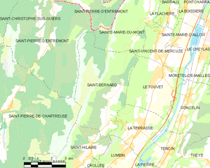
Ле-Туве (Le Touvet, Le Touvet)

- коммуна во Франции
 Hiking in Ле-Туве
Le Touvet is a charming village located in the French Alps, near the Belledonne mountain range, making it an excellent destination for hiking enthusiasts. The area offers a variety of trails that cater to different skill levels, from easy walks suitable for families to more challenging treks for experienced hikers.
Notable Hiking Trails:
-
Col de Vence: A popular hike that rewards you with stunning panoramic views of the surrounding mountains and valleys. The trail is well-marked and offers a good workout with some elevation gain.
-
Cascade de la Pisse: This trail leads to a beautiful waterfall and is often chosen for its scenic beauty and relatively easy terrain. It’s perfect for a short family hike or for those looking to enjoy nature without a strenuous effort.
-
Les Crêtes de Belledonne: For those seeking a more challenging adventure, this high-altitude trail involves more demanding terrain but provides breathtaking views. You might encounter alpine wildlife and diverse flora along the way.
-
Le Touvet to Lumbin: This hike is often recommended for its mix of forested areas and open spaces, providing hikers with varied landscapes. It’s a moderate trek and well-suited for those looking to enjoy a full day's hike.
Preparing for Your Hike:
-
Gear: Ensure you have appropriate hiking boots, weatherproof clothing, and plenty of water. Trekking poles can be useful for more challenging terrain.
-
Map and Navigation: Make sure to have a map of the area or a reliable hiking app. Cell signal can be spotty in remote areas, so offline maps can be helpful.
-
Weather Considerations: The weather in the Alps can change rapidly, so check forecasts and be prepared for cold winds or rain, even in the summer months.
-
Local Wildlife: Be aware that you may encounter wildlife. It's essential to respect their space and follow guidelines for interacting with wild animals.
Best Seasons to Hike:
- Spring and Fall: These seasons offer mild weather and beautiful landscapes with blooming flowers or colorful autumn foliage.
- Summer: Ideal for longer hikes, though it can be busy and hot on lower trails.
- Winter: Offers opportunities for snowshoeing or winter hiking for those equipped for cold conditions.
Le Touvet and its surroundings provide an incredible opportunity to experience the natural beauty of the French Alps, making it a must-visit for hikers!
- Страна:

- Почтовый код: 38660
- Координаты: 45° 21' 27" N, 5° 56' 53" E


- GPS треки (wikiloc): [Ссылка]
- Площадь: 11.56 кв.км
- Население: 3231
- Веб сайт: http://www.letouvet.com
- Википедия русская: wiki(ru)
- Википедия английская: wiki(en)
- Википедия национальная: wiki(fr)
- Хранилище Wikidata: Wikidata: Q592837
- Катеория в википедии: [Ссылка]
- код Freebase: [/m/03nvkrp]
- код GeoNames: Альт: [2999131]
- номер SIREN: [213805112]
- код BNF: [15258311n]
- код VIAF: Альт: [243888855]
- WOEID: [604722]
- код места в Foursquare: [4cbf66d0985aa35db0c24612]
- код муниципалитета INSEE: 38511
Граничит с регионами:


Гонселен
- коммуна во Франции
Hiking in Гонселен
Goncelin is a small commune located in the Isère department in the Auvergne-Rhône-Alpes region of southeastern France. Nestled in the picturesque Belledonne mountain range, it offers various hiking opportunities that combine beautiful scenery, diverse landscapes, and the chance to explore the local flora and fauna....
- Страна:
- Почтовый код: 38570
- Координаты: 45° 20' 34" N, 5° 58' 45" E
- GPS треки (wikiloc): [Ссылка]
- Площадь: 14.36 кв.км
- Население: 2334
- Веб сайт: [Ссылка]


Сен-Венсан-де-Меркюз
- коммуна во Франции
Hiking in Сен-Венсан-де-Меркюз
Saint-Vincent-de-Mercuze, located in the Isère department of the Auvergne-Rhône-Alpes region in southeastern France, offers a variety of hiking opportunities amidst beautiful natural landscapes. Here are some highlights of hiking in this area:...
- Страна:
- Почтовый код: 38660
- Координаты: 45° 22' 27" N, 5° 56' 59" E
- GPS треки (wikiloc): [Ссылка]
- Площадь: 7.85 кв.км
- Население: 1481
- Веб сайт: [Ссылка]

Сен-Бернар
Hiking in Сен-Бернар
Hiking in Saint-Bernard, Isère, offers numerous trails and breathtaking views that showcase the stunning landscape of the French Alps. The region is characterized by its diverse terrain, which includes mountains, forests, and valleys that provide a variety of hiking experiences for all skill levels....
- Страна:
- Почтовый код: 38660
- Координаты: 45° 19' 46" N, 5° 54' 12" E
- GPS треки (wikiloc): [Ссылка]
- Площадь: 21.59 кв.км
- Население: 623
- Веб сайт: [Ссылка]


Сент-Мари-дю-Мон
Hiking in Сент-Мари-дю-Мон
Sainte-Marie-du-Mont is a charming village located in the Isère department of the Auvergne-Rhône-Alpes region in southeastern France. This area is known for its stunning natural landscapes and variety of outdoor activities, making it a great destination for hiking enthusiasts....
- Страна:
- Почтовый код: 38660
- Координаты: 45° 24' 22" N, 5° 56' 44" E
- GPS треки (wikiloc): [Ссылка]
- Площадь: 23.87 кв.км
- Население: 237
- Веб сайт: [Ссылка]


Ла-Террас
- коммуна во Франции
Hiking in Ла-Террас
La Terrasse is a charming town in the Auvergne-Rhône-Alpes region of France, known for its picturesque landscapes and access to various hiking trails. Here are some aspects to consider if you're planning to hike in La Terrasse:...
- Страна:
- Почтовый код: 38660
- Координаты: 45° 19' 25" N, 5° 55' 52" E
- GPS треки (wikiloc): [Ссылка]
- Площадь: 9.47 кв.км
- Население: 2567
- Веб сайт: [Ссылка]