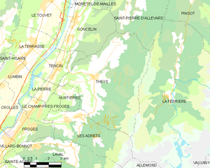
Тансен (Tencin, Tencin)

- коммуна во Франции
 Hiking in Тансен
Tencin, located in the Auvergne-Rhône-Alpes region of France near Grenoble, offers beautiful hiking opportunities amidst stunning natural landscapes. The area features diverse terrain, including hills, forests, and views of the Chartreuse Mountains, making it ideal for hikers of all skill levels.
Hiking Trails:
-
Les Sentiers de Tencin: There are several well-marked trails around Tencin suitable for various levels of experience. You can find loop trails that range from easy walks to more challenging hikes.
-
Chartreuse Mountains: The trails that lead from Tencin into the nearby Chartreuse Mountain range provide breathtaking panoramic views and the chance to explore diverse flora and fauna.
-
Local Nature Reserves: The nearby nature reserves might have dedicated trails that allow you to appreciate the local biodiversity while hiking.
Tips for Hiking in Tencin:
- Preparation: Always check the weather forecast and prepare accordingly. Proper footwear and hydration are essential.
- Maps: Consider carrying a map or using a hiking app to ensure you're on the right path.
- Stay Safe: Familiarize yourself with any signs or markers to avoid getting lost. Always inform someone about your hiking plans.
Best Time to Hike:
The ideal hiking seasons are typically spring and fall when the weather is mild, and the landscapes are particularly beautiful. Summer can be hot, while winter hikes may require snow gear and technique.
Whether you're looking for a leisurely stroll or a vigorous hike, Tencin's surroundings offer a delightful experience for nature lovers. Enjoy your adventure!
- Страна:

- Почтовый код: 38570
- Координаты: 45° 18' 34" N, 5° 57' 37" E


- GPS треки (wikiloc): [Ссылка]
- Площадь: 6.75 кв.км
- Население: 1984
- Веб сайт: http://www.tencin.net
- Википедия русская: wiki(ru)
- Википедия английская: wiki(en)
- Википедия национальная: wiki(fr)
- Хранилище Wikidata: Wikidata: Q1153213
- Катеория в википедии: [Ссылка]
- код Freebase: [/m/03nvjk5]
- код GeoNames: Альт: [6433427]
- номер SIREN: [213805013]
- код BNF: [152583031]
- код муниципалитета INSEE: 38501
Граничит с регионами:


Гонселен
- коммуна во Франции
Hiking in Гонселен
Goncelin is a small commune located in the Isère department in the Auvergne-Rhône-Alpes region of southeastern France. Nestled in the picturesque Belledonne mountain range, it offers various hiking opportunities that combine beautiful scenery, diverse landscapes, and the chance to explore the local flora and fauna....
- Страна:
- Почтовый код: 38570
- Координаты: 45° 20' 34" N, 5° 58' 45" E
- GPS треки (wikiloc): [Ссылка]
- Площадь: 14.36 кв.км
- Население: 2334
- Веб сайт: [Ссылка]

Те
- коммуна во Франции
Hiking in Те
Theys is a charming commune in the French Alps, situated in the Isère department. It's a fantastic location for hiking enthusiasts, offering a variety of trails that cater to different skill levels. Here are some key points about hiking in Theys:...
- Страна:
- Почтовый код: 38570
- Координаты: 45° 18' 1" N, 5° 59' 49" E
- GPS треки (wikiloc): [Ссылка]
- Площадь: 35.77 кв.км
- Население: 1943
- Веб сайт: [Ссылка]


Лембен
- коммуна во Франции
Hiking in Лембен
Lumbini, located in Nepal, is primarily known as the birthplace of Siddhartha Gautama, who became the Buddha. While it is mainly a pilgrimage site, it also offers a serene environment for hiking and exploring the natural beauty surrounding the area....
- Страна:
- Почтовый код: 38660
- Координаты: 45° 18' 24" N, 5° 54' 45" E
- GPS треки (wikiloc): [Ссылка]
- Площадь: 6.77 кв.км
- Население: 2143
- Веб сайт: [Ссылка]


Ла-Пьер
- коммуна во Франции
Hiking in Ла-Пьер
La Pierre, which could refer to various locations depending on the region, features stunning landscapes and diverse hiking opportunities. If you're specifically referring to a popular hiking region called La Pierre, please provide more details such as the country or specific park name, and I can give you tailored information....
- Страна:
- Почтовый код: 38570
- Координаты: 45° 17' 37" N, 5° 56' 54" E
- GPS треки (wikiloc): [Ссылка]
- Площадь: 3.31 кв.км
- Население: 570
- Веб сайт: [Ссылка]


Ла-Террас
- коммуна во Франции
Hiking in Ла-Террас
La Terrasse is a charming town in the Auvergne-Rhône-Alpes region of France, known for its picturesque landscapes and access to various hiking trails. Here are some aspects to consider if you're planning to hike in La Terrasse:...
- Страна:
- Почтовый код: 38660
- Координаты: 45° 19' 25" N, 5° 55' 52" E
- GPS треки (wikiloc): [Ссылка]
- Площадь: 9.47 кв.км
- Население: 2567
- Веб сайт: [Ссылка]