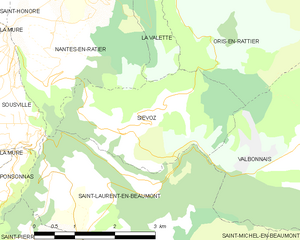
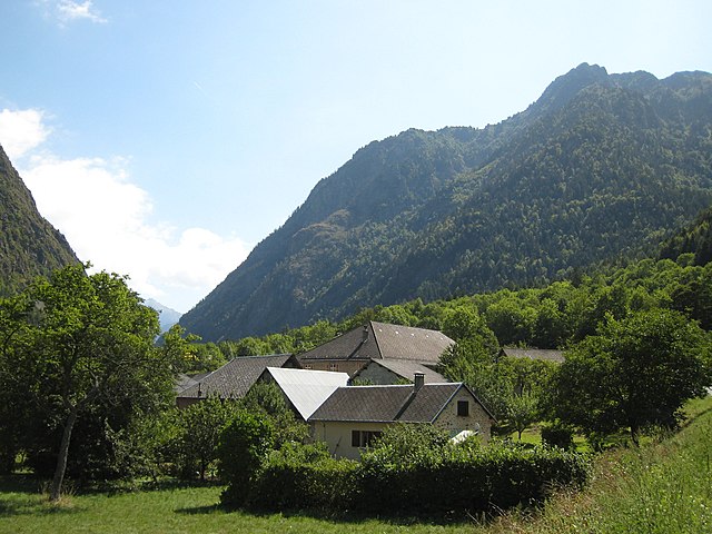
Вальбонне (Valbonnais, Valbonnais)

- коммуна во Франции
 Hiking in Вальбонне
Valbonnais is a beautiful area located in the French Alps, specifically in the Isère department. It’s known for its stunning natural landscapes, diversity of hiking trails, and rich cultural heritage. Here’s what you need to know about hiking in Valbonnais:
Trails
-
Variety of Difficulty Levels: Valbonnais offers a range of hiking trails suitable for different skill levels, from easy walks suitable for families to challenging treks for experienced hikers.
-
Scenic Routes: The region boasts breathtaking views of the surrounding mountains, lush valleys, and pristine lakes. Some popular trails take you to high peaks with panoramic views.
-
Local Routes:
- Col de la Montagne: A popular route that provides access to scenic mountain passes.
- Lac du Grand Doménon: A lovely hike that leads to a beautiful alpine lake.
Best Seasons
- Summer: From June to September, the weather is typically warm and the trails are fully accessible. Wildflowers are in bloom, making for a picturesque hiking experience.
- Autumn: Late September to October offers beautiful fall foliage, perfect for scenic hikes.
Preparation and Safety
- Gear: Ensure you have appropriate hiking gear, including sturdy boots, weather-appropriate clothing, and a good backpack. Don’t forget plenty of water and snacks.
- Maps and Navigation: Familiarize yourself with the trails through maps or apps and consider downloading a map before heading out, as some areas may not have reliable cell service.
- Guided Hikes: If you’re unsure about navigating the trails, consider joining a guided hiking tour to learn more about the local environment and history.
Wildlife and Nature
Valbonnais is home to a variety of wildlife, including chamois, marmots, and various bird species. Keep an eye out for different flora and fauna while hiking, and remember to respect local wildlife by keeping a safe distance.
Accessibility
- Transportation: Depending on where you’re coming from, public transportation and local trails can make it easier to access starting points for hikes. Make sure to check local schedules.
Local Culture
Exploring the small villages in the Valbonnais area can enhance your hiking experience. You might find local markets, traditional food, and cultural events that reflect the rich heritage of the region.
Conclusion
Hiking in Valbonnais is an enriching experience, combining physical activity with the beauty of the Alps. Whether you’re an experienced hiker or looking for a leisurely nature walk, Valbonnais has something to offer. Always check local guides for up-to-date trail conditions and information before you go.
- Страна:

- Почтовый код: 38740
- Координаты: 44° 54' 0" N, 5° 54' 15" E


- GPS треки (wikiloc): [Ссылка]
- Площадь: 23.95 кв.км
- Население: 499
- Веб сайт: http://www.ot-valbonnais.fr
- Википедия русская: wiki(ru)
- Википедия английская: wiki(en)
- Википедия национальная: wiki(fr)
- Хранилище Wikidata: Wikidata: Q475869
- Катеория в википедии: [Ссылка]
- код Freebase: [/m/03g_1l5]
- код GeoNames: Альт: [2971118]
- номер SIREN: [213805187]
- код BNF: [152583182]
- код VIAF: Альт: [242623177]
- WOEID: [629804]
- код муниципалитета INSEE: 38518
Граничит с регионами:

Сьево
- коммуна во Франции
Hiking in Сьево
Siévoz is a beautiful area in the French Alps, known for its scenic landscapes and hiking opportunities. If you're planning a hiking trip there, here are some key points to consider:...
- Страна:
- Почтовый код: 38350
- Координаты: 44° 54' 12" N, 5° 50' 15" E
- GPS треки (wikiloc): [Ссылка]
- Площадь: 7.37 кв.км
- Население: 136


Ле-Перье
- коммуна во Франции
Hiking in Ле-Перье
Le Périer is a charming village located in the Isère department of the Auvergne-Rhône-Alpes region in southeastern France. It's situated near the Vercors Regional Natural Park, which offers a variety of hiking opportunities for outdoor enthusiasts....
- Страна:
- Почтовый код: 38740
- Координаты: 44° 56' 13" N, 5° 58' 24" E
- GPS треки (wikiloc): [Ссылка]
- Площадь: 47.99 кв.км
- Население: 137


Ори-ан-Ратье
- коммуна во Франции
Hiking in Ори-ан-Ратье
Oris-en-Rattier is a charming little village in the Isère department in the Auvergne-Rhône-Alpes region of France. Nestled within the stunning landscapes of the French Alps, it offers a range of hiking opportunities for enthusiasts of all levels....
- Страна:
- Почтовый код: 38350
- Координаты: 44° 55' 16" N, 5° 52' 12" E
- GPS треки (wikiloc): [Ссылка]
- Площадь: 18.83 кв.км
- Население: 111

Антрег
- коммуна во Франции
Hiking in Антрег
Entraigues, located in the Isère department of the Auvergne-Rhône-Alpes region in southeastern France, is a charming village surrounded by beautiful natural landscapes, making it a great destination for hiking enthusiasts. Here are some key aspects to consider when planning your hike in this area:...
- Страна:
- Почтовый код: 38740
- Координаты: 44° 54' 6" N, 5° 56' 53" E
- GPS треки (wikiloc): [Ссылка]
- Высота над уровнем моря: 800 м m
- Площадь: 21.66 кв.км
- Население: 235


Сен-Лоран-ан-Бомон
- коммуна во Франции
Hiking in Сен-Лоран-ан-Бомон
Saint-Laurent-en-Beaumont is a charming commune located in the Isère department in the Auvergne-Rhône-Alpes region of southeastern France. It offers excellent opportunities for hiking and outdoor activities, set amidst stunning natural scenery, including mountains and forests....
- Страна:
- Почтовый код: 38350
- Координаты: 44° 52' 45" N, 5° 51' 1" E
- GPS треки (wikiloc): [Ссылка]
- Площадь: 13.15 кв.км
- Население: 462
- Веб сайт: [Ссылка]


Сен-Мишель-ан-Бомон
- коммуна во Франции
Hiking in Сен-Мишель-ан-Бомон
Saint-Michel-en-Beaumont is a picturesque village located in the Auvergne-Rhône-Alpes region of southeastern France. This area is known for its stunning natural landscapes, rolling hills, and diverse outdoor activities, making it a great destination for hiking enthusiasts....
- Страна:
- Почтовый код: 38350
- Координаты: 44° 52' 6" N, 5° 53' 59" E
- GPS треки (wikiloc): [Ссылка]
- Площадь: 8.04 кв.км
- Население: 31
- Веб сайт: [Ссылка]